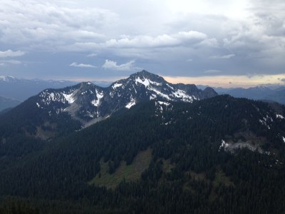
Mount Fernow (Wild Sky)
A moderate scramble to one of the crown jewels of the Wild Sky Wilderness. Not to be confused with Mount Fernow next to Mount Maude in the Entiat.
Despite a summit elevation of only 6190', Mount Fernow and its standard approach have the essence of sub-alpine and alpine areas found on much higher terrain elsewhere in the Cascade Mountains.
APPROACH AND ASCENT
Follow the ridgeline South the SE until you reach Pt 5403 where you will want to continue traversing East and a bit North East rather than following the southern ridge. Stay high as you traverse around the west side of Jake's Lake. Once you are on the opposite side of the lake head straight up to the summit.
Driving Directions
From Skykomish drive east along Highway 2. After ~0.6 miles, turn left (north) onto Beckler Road (a.k.a. Forest Road 65). After ~7.0 miles, make a hard-right turn (almost a u-turn) onto Forest Road 6520, which immediately heads uphill.
NOTE: There are two right-turn side roads at this intersection, Forest Road 6530 on the leftside that follows Rapid River, and Forest Road 6520 on the rightside that immediately heads uphill and leads towards Mount Johnson Ridge and Mount Fernow. Continue for 2.7 miles then veer right onto Forest Road 6524. Some maps and signs might show this road as Forest Road 6522. Stay on the main road (Forest Road 6522) as it bends left and uphill to the ridgetop where the road ends. This is about 2.5 to 3 miles. High-clearance vehicles are definitely recommended.
- Suitable Activities: Scrambling
- Seasons: June, July, August, September, October
- Weather: View weather forecast
- Difficulty: Strenuous 4, Technical 5
- Length: 8.0 mi
- Elevation Gain: 2,000 ft
- 6,190 ft
-
Land Manager:
Mount Baker-Snoqualmie National Forest
Wild Sky Wilderness
- Parking Permit Required: Northwest Forest Pass
- Recommended Party Size: 12
- Maximum Party Size: 12
- Maximum Route/Place Capacity: 12
- Green Trails Skykomish No. 175
There are no resources for this route/place. Log in and send us updates, images, or resources.
