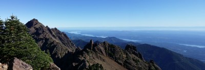
Mount Ellinor
Mount Ellinor is a strenuous, 6.2 mile round-trip day hike with 3,344 ft in elevation gain. The trail goes up forested slopes to fantastic views of the Olympics. The trail can also be approached via an upper trailhead which shaves off 1,300 feet of gain and 1.8 miles (3.6 round trip).
Getting there
From US-101 in Hoodsport, turn west onto SR-119 (North Lake Cushman Road) and drive 9.4 miles to a T intersection. Turn right on Forest Road 24 and in 1.5 miles, turn left on Forest Road 2419.
- Mount Ellinor Lower Trailhead: Continue on Forest Road 2419 for 4.4 miles to the small parking lot and the Mount Ellinor lower trailhead (2,800 ft).
- Mount Ellinor Upper Trailhead: Continue on Forest Road 2419 for 6.2 miles (1.8 miles past the lower trailhead), turn left onto Forest Road 2419-014, and continue 1 mile to the Mount Ellinor upper trailhead (3,500 ft).
TRIP Profile
| Trail Segment | Mileage | Elevation |
|---|---|---|
| Lower Trailhead | 0.0 mi | 2,600 ft |
| Junction with Upper Trail | 1.8 mi | 3,900 ft |
| Junction with winter climbing route | 2.5 mi | 4,500 ft |
| Summit | 3.1 mi | 5,944 ft |
Notes
- It is a non-stop workout with constantly rewarding views.
- It's the most accessible summit in the Olympics.
- Be on the lookout for goats.
Information for leaders
- If you are planning a scramble or climb, please use the Mount Ellinor & Mount Washington route/place.
- Suitable Activities: Day Hiking
- Seasons: July, August, September, October
- Weather: View weather forecast
- Difficulty: Strenuous
- Length: 6.6 mi
- Elevation Gain: 3,270 ft
- 5,944 ft
-
Land Manager:
Olympic National Forest
Mount Skokomish Wilderness, Hood Canal Ranger District (ONF)
- Parking Permit Required: Northwest Forest Pass
- Recommended Party Size: 12
- Maximum Party Size: 12
- Maximum Route/Place Capacity: 12
- Green Trails Olympic Mountains East No. 168S
- Green Trails Mt Steel No. 167
- Green Trails The Brothers No. 168
- Custom Correct Mount Skokomish - Lake Cushman
There are no resources for this route/place. Log in and send us updates, images, or resources.
