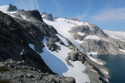
Mount Daniel/Lynch Glacier
A moderate glacier climb up the north side of Mount Daniel was the route of the first recorded ascent, made in 1925 by a Mountaineers Party. The peak is located in the heart of the Alpine Lakes Wilderness. In late season, crevasses that extend the full width of the glacier add to the challenge, along with route-finding and descending rotten, loose rock to access the glacier. Times: 2.5-4 hr trailhead to camp, 5-7 hr camp to summit.
getting there
Take I-90 about 27 mi east of Snoqualmie Pass to the Roslyn exit (about 1 mi west of Cle Elum exit). Follow the Cle Elum River Road (SR 903) to Salmon La Sac. A few yards past the Ranger Station, keep right on a rough dirt road (Forest Road 4330). Drive about 12 mi to the end of the road and the Cathedral Rock trailhead (3,350 ft).
APPROACH
Hike the Cathedral Rock Trail to Squaw Lake at 2.5 mi. Continue up trail to Cathedral Pass (5,550 ft).Turn left (west) onto the Pacific Crest Trail. In less than 0.5 mi, turn right (northwest) onto Trail No. 1375 (do not follow the Pacific Crest Trail down to Deep Lake). Follow Trail No. 1375 past Cathedral Rock to Peggy's Pond at 5,560 ft and camp nearby. This is the shorter approach (longer summit day) and avoids the brush of the alternate approach. It's also possible to begin the ascent and camp on snow at Pea Soup Lake.
Early Season alternative
From Deception Pass Trailhead, hike past the upper end of the Hyas Lakes ~0.25 mi (3+ miles from the trailhead, 3,500 ft). Here, cross the stream and watch for ribbon markers going up Lynch Draw. There are two routes between Hyas Lake and Pacific Crest Trail (PCT)—the left one is the better choice. Continue up until you cross the PCT at ~4,000 ft. Follow the PCT northwest about 150 yards and leave the trail at a stream bed. Follow the stream bed until reaching the basin. Stay to the left of the stream, working over to low ridge (a way trail on the crest of the ridge) to Lynch Gap at 6,250 ft (~2 mi from the PCT). The trails are faint and easily lost and regained.
ASCENT ROUTE
From camp at Peggy's Pond, climb to 6,300 ft on the east ridge. Traverse below the Daniel Glacier at 6,100-6,300 ft to the vicinity of Lynch draw. Walk across frozen Pea Soup Lake and get on the ice above low rocks. Ascend glacier to the gap between the two highest summits (in late season, expect detour around the crevasses about two-thirds of the way up the glacier). The west summit on the right of the notch is the highest. No credit is given for ascending either the Souteast Ridge or Hyas Creek Glacier to the upper Daniel Glacier from Peggy's Pond (both are scrambles).
Late Season alternative
Late in season, Lynch Draw may be flooded and Pea Soup Lake melted out. Lynch Glacier can be reached by ascending the ridge between the Daniel and Lynch Glaciers a couple hundred yards to first minor notch (~6,600 ft). Then descend ~100 feet to a snowfield hugging the ridge and snow slopes ascending climber's left via another snowfield and rock benches to the Lynch Glacier.
DESCENT ROUTE
Descend the scramble route to the camp at Peggy’s Pond or descend the climbing route.
TRIP PROFILE
| SEGMENT | TIME (HR) | ELEVATION GAIN (FT) |
|---|---|---|
| Trailhead to Camp | 2.5-4 | 3,000 |
| Camp to Summit | 5-7 | 1,800 |
| Summit to Camp | 2-3 | |
| Camp to Trailhead | 3-4 |
EQUIPMENT
Standard glacier equipment.
NOTES
- USGS topo maps mislabel the summit. The true summit is the west peak.
- The Pea Soup Lake approach becomes problematic in mid-July and later, once the ice melts.
- Expect bugs at Peggy's Pond.
- No credit is given for ascending either the Southeast Ridge or Hyas Creek Glacier to the upper Daniel Glacier from Peggy’s Pond (both are scrambles).
- Suitable Activities: Climbing
- Climbing Category: Basic Alpine
- Seasons: June, July, August
- Weather: View weather forecast
- Difficulty: Basic Glacier Climb, Strenuous 2, Technical 2, Basic Experience Climb
- Length: 16.0 mi
- Elevation Gain: 5,000 ft
- 7,986 ft
-
Land Manager:
Mount Baker-Snoqualmie National Forest
Alpine Lakes Wilderness, Skykomish Ranger District (MBSNF)
- Parking Permit Required: Northwest Forest Pass
- Recommended Party Size: 12
- Maximum Party Size: 12
- Maximum Route/Place Capacity: 12
- USGS Mt Daniel
- Green Trails Stevens Pass No. 176
- USGS The Cradle
There are no resources for this route/place. Log in and send us updates, images, or resources.
