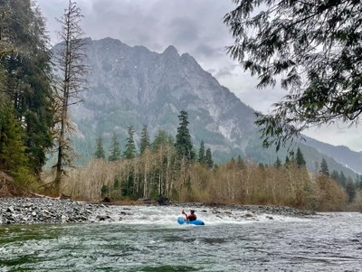
Snoqualmie River (Middle Fork - Upper): Dingford Creek to MF Trailhead
A hike-to-packraft day trip with options for both Class III boaters and Class II boaters alike. Stunning views of Mt. Garfield appear nearly continuously along the river route.
FLOW
- NOAA Gauge: MF SNOQUALMIE--NEAR TANNER (TANW1)
- <800 CFS: not recomended
- 800 - 1,200 CFS: low but runnable
- 1,200 - 2,000 CFS: prime runnable
- 2,000 - 3,000 CFS: pushy but runnable
TAKE-OUT
- Middle Fork Trailhead: Take Exit 34 off I-90 and drive north on 468th Ave past the truck stop. In 0.5 miles, turn right onto Middle Fork Road. Proceed to mile 11.5 and the signed entrance is on the right. There are several large parking lots and toilets. From the river, shortly after the Taylor River merges from the right, the wooden arch footbridge comes into view. The take out is on the downstream side of the footbridge on river left. There is a convenient use trail up to the bridge.
PUT-IN
- Cripple Creek: This is the put in for class II boaters. Strap your boat, paddle, and gear on to your pack and hike up the serene MF Trail for 4.5 miles. The trail is typically well-maintained and is a worthwhile hike in its own right, but of course much funner to float back than to hike back. Start your hike by crossing over the wooden arch pedestrian bridge. On the opposite side of the river, head left and upstream. About halfway along the hike, be sure to visit the 9 Hour Giant old growth cedar. The Giant is off the trail on the left just past 9 Hour Creek. Soon you will be astride of the river. Go up one more hill and back down near the riverside. There is a short use trail leading to the river and the put in at 47.5225, -121.4759.
- Backcountry Camp: This is the put in for class III boaters. Continue hiking past the Cripple Creek Put In for 1.25 miles. You will see a camping area on the left. Take the maintained trail down to camp, and head right to a cobble beach. The waypoint is 47.5181, -121.4615. This launch is in the middle of a 300 foot long continuous class III rapid. For those not ready for this abrupt action after your calm and peaceful hike, scramble down river left to the bottom of the rapid.
ON THE RIVER
The class III section from Backcountry Camp starts with read and run ledge drops with recovery sections for 1/4 mile. Beware of wood as it is common to portage in the middle of this section as the river flows through a braided section. After Cripple Creek enters from the left the river gets much calmer and becomes class II. After a couple miles, the river valley widens and the drops mellow out. For almost the entire reach there are stunning views of the massive granite walls of Mt. Garfield. Typical of Washington rivers, there are intermittent wood hazards that usually offer room to float past.
NOTES
- The reach from Cripple Creek to MF Trailhead is 4.5 miles of class II with a gradient of 35 feet/mile
- The reach from Backcountry Camp to Cripple Creek is 1 mile of class III+, with a gradient 50 fett/mile
- The section above Wildcat Creek, from Burnboot Creek to Wildcat Creek, is described as predominantly a flat portage hell after a short class III section at the start, as it drops 70 feet/mile.
- This route can be combined with Upper Middle Fork Snoqualmie River for a longer run.
- Learn more on American Whitewater's Snoqualmie, Snoqualmie, Middle Fork 2 Burnboot Creek to Taylor River web page.
- Suitable Activities: Packrafting
- Seasons: Year-round
- Weather: View weather forecast
- Difficulty: Class III River, Class II River
- Length: 5.7 mi
-
Land Manager:
Land Manager Varies
Middle Fork Snoqualmie National Wild and Scenic River, Snoqualmie Ranger District (MBSNF)
- Parking Permit Required: see Land Manager
- Recommended Party Size: 7
- Maximum Party Size: 12
- Maximum Route/Place Capacity: 12
This is a list of titles that represent the variations of trips you can take at this route/place. This includes side trips, extensions and peak combinations. Not seeing a title that fits your trip? Log in and send us updates, images, or resources.
- Upper Upper Middle Fork Snoqualmie River
There are no resources for this route/place. Log in and send us updates, images, or resources.
