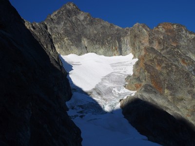
Meashchie Peak/Mesahchie Icefall Couloir
A Grade III alpine ice climb in the heart of the North Cascades.
getting there
Take Exit 232 (Cook Road) off of I-5 at Burlington, turning east to Sedro Wooley and SR-20. Turn left and continue 47 miles to the Marblemount Ranger Station for climb registration and trip permits. Continue on SR-20 east for 32 miles past Newhalem to the Easy Pass trailhead, 5 miles before Rainy Pass.
Approach
Follow trail 3 miles to Easy Pass, 6,600 feet. A good bivy site is about 1 mile WNW at 7,000 ft on the south side of Ragged ridge just south of Mesahchie Col and east of the 7,985-foot subpeak. There are two ways to get there. The first option is to traverse WNW at roughly 6,800 feet on heather and tiresome scree. The second option (reportedly with better footing) is to climb a grassy slope just past Easy Pass to the ridge crest (7,200 ft) and follow the ridge until it heads up towards the 7,690-foot point and the terrain becomes more technical. Traverse under this point on scree and regain the ridge crest as soon as possible once past it, follow the ridge until almost above the 7,000-foot camp, and then descend to camp on scree. The campsite may be dry in late season.
Ascent Route
From camp, scramble to Mesahchie Col, then descend to Mesahchie Glacier on north side of Ragged Ridge until able to contour below the north side of Point 7,985 – here the icefall comes into view. Keep traversing west across the glacier to below the icefall. The right side tends to be less broken up. Climb 2-4 pitches up the icefall. Negotiate crevasses to below the exit couloir on the left. Climb two additional pitches up the couloir. It is possible to move left onto easy rock after first pitch in couloir. From the top of the couloir (8,100 ft) descend about 100 feet on the south side of the ridge to enter a Class 3 gully with beige rock. Climb this gully to where it steepens and a notch becomes visible on the left side. Climb through the notch on a Class 4 deep cut and traverse into second gully. This Class 3 gully leads to the ridge crest. Follow the crest until you reach a steep technical step. Bypass this by traversing to the north side and a short Class 4 section back to the crest at the end of a ledge. From here exposed Class 3-4 climbing continues on or near the crest to the summit over several humps on the ridge.
TRIP PROFILE
| SEGMENT | TIME (HR) | ELEVATION GAIN (FT) | Distance (mi) |
|---|---|---|---|
| Trailhead to Camp | 4-5 | 3,600 | 4.5 |
| Camp to Summit | 6-7 | 1,800 | 2.0 |
| Summit to Camp | 3-5 | -1,800 | 1.5 |
| Camp to Trailhead | -3,600 | 4.5 |
Descent Route
Down climb the route to the top of couloir. From here, make a descending traverse southeast below the 7,985-foot subpeak. Stay around 7,400 ft during this traverse until a large scree field is reached. Cross this field is at its bottom where the slope transitions to heather. Once across continue on easier terrain to camp.
Equipment
Ice tools, ice screws, pickets, small rock rack (rock pro can be placed in the couloir and if desired on the summit scramble).
Notes
- While the ice climbing portion is suitable for less experienced students the whole climb is more suitable to climbers who can move efficiently over exposed terrain on the approach, summit scramble and hike back to camp. Expect 10+ hours long round trip from camp.
- This long climb is probably best scheduled for three days.
- Suitable Activities: Climbing
- Climbing Category: Intermediate Alpine
- Seasons: July, August, September
- Weather: View weather forecast
- Difficulty: Intermediate Ice Climb
- Length: 12.0 mi
- Elevation Gain: 5,400 ft
- 8,975 ft
-
Land Manager:
North Cascades National Park
Stephen Mather Wilderness
- Parking Permit Required: None
- Recommended Party Size: 12
- Maximum Party Size: 12
- Maximum Route/Place Capacity: 12
- USGS Mt Arriva
- USGS Mt Logan
- Trails Illustrated North Cascades National Park
There are no resources for this route/place. Log in and send us updates, images, or resources.
