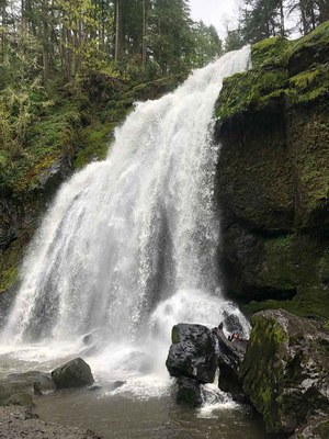
Little Mashel Falls
A short, year-round 5-mile round trip hike with 500 feet of elevation gain in the University of Washington's Charles L. Pack Experimental Forest. This hike visits three spectacular waterfalls!
getting there
Pack Forest Trailhead
The Charles L. Pack Experimental Forest Trailhead is on SR-7 just east of the intersection with SR-161, south of Eatonville.
Bud Blancher Trailhead
The Bud Blancher Trailhead is in Eatonville on Center Street E, 0.2 miles east of the stoplight at the intersection of SR-161 and Center Street E.
on the trail
The 5-mile round trip and 500 feet of elevation gain is the same from either trailhead.
notes
- For more hikes i the area, visit our Pack Forest route/place.
- A map is available at the gate house and at packforest.org.
- There are a variety of trails and roads. Horses and mountain bikes may use some of the trails and roads. Motorcycles and vehicles can use the main gravel roads.
- Hunting is allowed away from the campus.
- Suitable Activities: Day Hiking
- Seasons: Year-round
- Weather: View weather forecast
- Difficulty: Easy
- Length: 5.0 mi
- Elevation Gain: 500 ft
- 1,100 ft
- Land Manager: Pack Forest
- Parking Permit Required: None
- Recommended Party Size: 8
- Maximum Party Size: 12
- Maximum Route/Place Capacity: 12
- see Land Manager
This is a list of titles that represent the variations of trips you can take at this route/place. This includes side trips, extensions and peak combinations. Not seeing a title that fits your trip? Log in and send us updates, images, or resources.
- Little Mashel Falls, Pack Forest Trailhead
- Little Mashel Falls, Bud Blancher Trailhead
- Little Mashel Falls, Pack Forest Trail
- Little Mashel Falls, Bud Blancher Trail
There are no resources for this route/place. Log in and send us updates, images, or resources.
