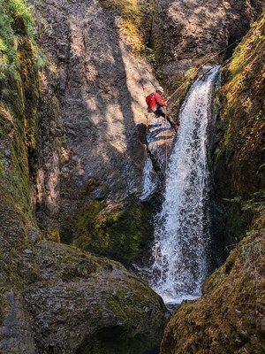
Lewis River (Mt. Adams)
A unique technical intermediate canyon located in the upper headwaters of the Lewis River on the northwestern flanks of Mt. Adams. The softer volcanic substrate yields narrows, potholes, waterfalls, and a committing lower section making this a classic northwest canyon. It's one of the prettier canyons in the area with striking orange/yellow rocks in the lower canyon.
Be aware: the Lewis River is glacial-fed from the snowfields high on Mt. Adams. It may be running considerably higher than other creeks in the area on hot summer days when a lot of melt is taking place high on the mountain. The water is often colder and siltier than others in the area. When the water is running high, you may expect to encounter serious hydraulics in the technical section, including the dangerous crux of the descent
Please see Ropewiki for the most current Route / Beta:
https://ropewiki.com/Lewis_River
Taken from Ropewiki:
This page describes a unique technical canyon located in the upper headwaters of the Lewis River on the northwestern flanks of Mt. Adams. The softer volcanic substrate yields narrows, potholes, waterfalls, and a committing lower section making this a classic northwest canyon. It's one of the prettier canyons in the area with striking orange/yellow rocks in the lower canyon.
- The Lewis River valley is quite extensive, draining a significant area of Mt. Adams, the Dark Divide, and Indian Heaven plateau. This page describes the technical section of the river way up in the headwaters, but there are many other technical canyons in the same watershed (ex: Big Creek, Cussed Hollow, Pin, Chickoon, etc). Most of these, however, are lesser tributaries of the Lewis River.
- Suitable Activities: Canyoning
- Seasons: July, August, September, October
- Weather: View weather forecast
- Length: 1.5 mi
- Land Manager: Gifford Pinchot National Forest
- Parking Permit Required: Northwest Forest Pass
- Recommended Party Size: 8
- Maximum Party Size: 12
- Maximum Route/Place Capacity: 12
There are no resources for this route/place. Log in and send us updates, images, or resources.
