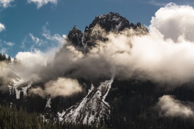
Lane Peak: Zipper & Lovers Lane
Two Grade II, intermediate-level winter climbs in the Tatoosh Range in Mount Rainier National Park. The Zipper is up to 45° snow and/or ice and Lovers Lane is up to 60° snow and/or ice.
getting there
From SR-7 in Elbe, turn east onto SR-706, both known as the National Park Highway. Continue through the Nisqually Entrance of Mount Rainier National Park. Be prepared to pay the fee just after entering the park. Drive 15 miles to Narada Falls.
- Winter drivers in the park are required to have snow chains, and may be required to install them at Longmire. \
- The gate at Longmire usually opens between 8am and 9am.
APPROACH
Follow around the side of the parking lot past a maintenance building and bathrooms, and proceed up the steep hillside to the road above which leads to Reflection Lakes in the summer. Follow snowshoe/ski tracks on the road away from Lane Peak until the first major hairpin turn. Turn off the road and down hill here. Drop through the forest until a flat, open clearing, then turn right (east) under Denman Peak and towards Lane. Traverse steep hillsides, gaining elevation.
At the first steep avalanche funnel turn sharply uphill to approach the base of Lovers Lane.
Traverse past Lover's Lane and proceed to the much larger, wider funnel and turn sharply uphill to approach the base of the Zipper.
Note the descent track is to the left of the rock nose below Lover's Lane. You may stash skis or snowshoes here if desired.
ASCENT ROUTE
Zipper
Rope up and climb placing pickets, and maybe 1-2 screws. Depending on conditions a rope may be overkill, and in other conditions a running belay may be appropriate. Reaching the top of the gully is sufficient for credit.To obtain the summit, traverse to climbers left until the slopes to the summit come into view. Ascend to the summit. Sometimes a belay up the last 200-300 feet is advisable.
Lover's Lane
Rope up below the first obvious constriction/steep section. Climb placing pickets, screws, and possibly rock pro on the wall on the left. The route steepens in two or three areas. A running belay may be appropriate based on conditions. At the top of the route, downclimb exposed terrain to a tree with rappel slings.
Rappel into the Zipper. The rappel is usually more than 100 ft, so a double rope rappel is recommended. With high snow, a 70 m rope may suffice, with some downclimbing on moderate snow. Evaluate the snow conditions and either rope-up or solo the next section up to the top of the Zipper. This is sufficient for credit.To obtain the summit, traverse to climbers left until the slopes to the summit come into view. Ascend to the summit. Sometimes a belay up the last 200-300 feet is advisable.
DESCENT ROUTE
Downclimb from a large tree a few feet below the summit. Rappel from this tree unless snow conditions are good enough to warrant a simple downclimb. Unrope and plunge step down moderate slopes to skiers left towards the saddle between Denman and Lane. At the saddle, go to the far left side and find a steep gully to descend. Retrieve packs and retraces steps to the car.
TRIP PROFILE
| SEGMENT | TIME (HR) | ELEVATION GAIN (FT) |
|---|---|---|
| Trailhead to Summit | 3 | 1,500 |
| Summit to Trailhead | 2 |
EQUIPMENT
Zipper
Ice ax, crampons, 2nd tool, pickets, 1-2 ice screws (early season).
Lover's Lane
Ice ax, crampons, second tool, pickets, ice screws, small rack for pro along rock side (nuts, small cams, Tricams, pitons).
Information for LEADERS
Intermediate Alpine Climbing Course Credit
Trip leaders are asked to use judgement in awarding Intermediate credit in conditions where it is unwarranted. Students should understand that achieving the summit does not guarantee credit. Steep snow and picket placements are characteristic of many Basic Alpine climbs. Intermediate climbs are obviously intended to carry a higher level of difficulty. Characterizing a route on a given day as "challenging enough" is obviously subjective.
- Suitable Activities: Climbing
- Climbing Category: Intermediate Alpine
- Seasons: January, February, December
- Weather: View weather forecast
- View avalanche forecast.
- Difficulty: Intermediate Mountaineering Climb
- Length: 5.0 mi
- Elevation Gain: 1,500 ft
- 6,012 ft
-
Land Manager:
Mount Rainier National Park
Mount Rainier Wilderness
- Parking Permit Required: National Park Entrance Fee
- Recommended Party Size: 12
- Maximum Party Size: 12
- Maximum Route/Place Capacity: 12
- USGS Mt Rainier East
- USGS Mt Rainier West
- Green Trails Mount Rainier Wonderland No. 269SX
This is a list of titles that represent the variations of trips you can take at this route/place. This includes side trips, extensions and peak combinations. Not seeing a title that fits your trip? Log in and send us updates, images, or resources.
- Lane Peak/Zipper
- Lane Peak/Lovers Lane
There are no resources for this route/place. Log in and send us updates, images, or resources.
