Klickitat Trail
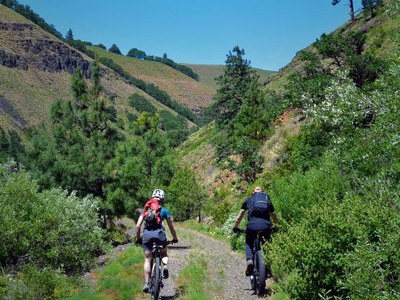
A spectacular rail trail in south central Washington that starts in Lyle where the Klickitat River meets the Columbia River. It is a unique opportunity to hike, bike, or run ride along the most scenic section the Klickitat River and Swale Canyon. The trail is 31 miles one-way to the Centerville Highway. It can be done as a 62-mile round trip out-and-back or 43-mile loop trip.
Getting There
The trail is served by five trailheads: Lyle, Pitt, Klickitat, Wahkiacus, and Harms Road. The trailhead in Lyle is the most often used. Te reach it, drive SR-14 to the town of Lyle, ~70 miles east of Vancouver, WA. The trailhead and parking is just east of the Klickitat River Bridge on the north side of SR-14.
On the Trail
The trail’s spectacular scenery includes carved gorges, interesting geologic formations, abundant wildflowers, rolling hills, oak and Ponderosa Pine woodlands. There are great birding opportunities, including winter habitat for bald eagles near the Lyle trailhead.
Klickitat Trail Conservancy
Travel north and east on the trail from Lyle 31 miles to the trail's end at Centerville Highway. Turn around here and head back, or turn onto Centerville Highway and travel west back to Lyle.
Camping
Then nearest camping options are limited to Mineral Springs Campground, a Washington Department of Fish & Wildlife primitive campsite outside of Klickitat, 15.5 miles from the Lyle Trailhead. A vault toilet and river water available there.
Notes
- Some sections of the route are very rough and wide bike tires and front suspension are recommended.
- Suitable Activities: Backpacking, Bikepacking, Day Hiking, Trail Running
- Seasons: March, April, May, September, October, November
- Weather: View weather forecast
- Difficulty: Moderate, Bikepacking Gravel II, Bikepacking Gravel III
- Length: 43.0 mi
- Elevation Gain: 2,356 ft
- 1,948 ft
- Land Manager: Klickitat State Park Trail
- Parking Permit Required: Discover Pass
- Recommended Party Size: 12
- Maximum Party Size: 12
- Maximum Route/Place Capacity: 12
This is a list of titles that represent the variations of trips you can take at this route/place. This includes side trips, extensions and peak combinations. Not seeing a title that fits your trip? Log in and send us updates, images, or resources.
- Klickitat Rail Trail
- Klickitat Trail Loop
- Klickitat Trail–Centerville Highway Loop
| Name/Description |
|---|
| Ride with GPS Map A Ride with GPS map of the bikepack loop route from Lyle posted on Oct 14, 2014 and updated Jun 10, 2017. |
| Klickitat Trail Gaia GPS TRack A link the Klickitat Trail Route on Gaia GPS by Emma Agosta May 13, 2022. |
