Japanese Gulch
An easy year-round four-mile urban hike with 174 feet of elevation gain through 147 acres owned by the City of Mukilteo. This hike takes you through a former WW II defensive barrier and over a stream into a wildlife habitat filled with flowering currants, bleeding hearts, black-tailed deer, birds, with open spaces and water views. The hiking trails are shared and intersect with a series of mountain bike trails.
getting there
The trails on both sides of the gulch in Mukilteo can be accessed on the north from the Tails and Trails Dog Park on 5th St.or from the Muliteo Community Garden at the intersection of 76th St SW and 44th Ave W.
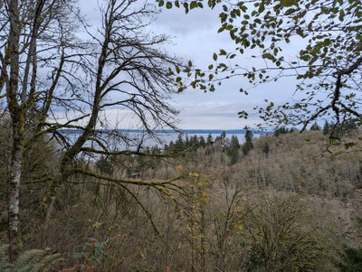
View of Puget Sound from a ridge on the north end of Japanese Gulch. Photo taken by Joshua Stein.
- Suitable Activities: Day Hiking, Urban Walking, Urban Adventure
- Seasons: Year-round
- Weather: View weather forecast
- Length: 4.0 mi
- Elevation Gain: 174 ft
- 363 ft
- Land Manager: City of Mukilteo Parks and Trails
- Parking Permit Required: None
- Recommended Party Size: 12
- Maximum Party Size: 12
- Maximum Route/Place Capacity: 12
- see Land Manager
This is a list of titles that represent the variations of trips you can take at this route/place. This includes side trips, extensions and peak combinations. Not seeing a title that fits your trip? Log in and send us updates, images, or resources.
- Japanese Gulch; Japanese Gulch Loop Trails;
There are no resources for this route/place. Log in and send us updates, images, or resources.
