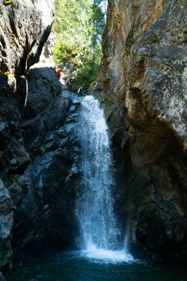
Incognito Canyon
An easy-access scenic Basic Canyon located along Kachess Lake. It's rated v3a3III at moderate-low water levels, and v3a4III in early to mid-season.
GETTING THERE
Take Exit 80 (Roslyn) off of I-90 and follow Bullfrog Road into Roslyn. Continue on SR-903 north until it becomes Salmon la Sac road. Turn left onto Forest Road 46 and follow that towards Cooper Lake. Just before Cooper Lake, continue straight onto Forest Road 4600. Follow Forest Road 4600 over Cooper Pass to the Mineral Creek Trailhead and leave a car here. To drive to the drop-in, return to the the top of Cooper Pass and turn south onto Forest Road 4617. At the junction with Forest Road 4617-120, take the hairpin turn to the right and follow this road ~0.25 mile and park.
APPROACH
Follow Forest Road 4617-120 which is overgrown but still hikeable until it disappears. Continue through the relatively open woods, staying high on the top of the knoll. If you stay too close to the creek, you will get cliffed out. Find a path down from the top of the knoll, descending down the hillside and eventually traversing left to the drop-in. Portions of this downhill section are quite steep with loose dirt and rock, so step carefully. Drop into the creek at 3000 ft. A rope may be needed as a handline to drop into the creek.
DESCENT
Incognito has 10-12 rapid-fire rappels that are all fairly straight forward. The rock in this canyon is very sharp. Abrasion management recommended.
EXIT
After the final rappel, scramble down to the lake. You will exit through a campsite accessible mainly to boaters. You may see people here. Be friendly but respect their privacy as you pass through. Swim about 100 yards along the shore until you can walk around the nose of the lake. A short scramble uphill leads to the Little Kachess Trail. Follow it about a mile back to your car at the Mineral Creek trailhead.
EQUIPMENT
Standard canyoning gear including webbing, a wrench, and replacement quick links.
TRIP PROFILE
- Rappels: 10-12
- Longest Rappel: 140 feet
- Approach: ~ 1 mile
- Exit: ~1.5 mile
- Time: 7-9 hours total
NOTES
- This canyon is rated v3a3III at moderate-low water levels, and v3a4III in early to mid-season.
- Suitable Activities: Canyoning
- Seasons: June, July, August, September
- Weather: View weather forecast
- Difficulty: Basic Canyon
-
Land Manager:
Okanogan-Wenatchee National Forests
Cle Elum Ranger District (OWNF)
- Parking Permit Required: Northwest Forest Pass
- Recommended Party Size: 6
- Maximum Party Size: 12
- Maximum Route/Place Capacity: 12
- Green Trails Kachess Lake No. 208
- USGS Polallie Ridge
There are no resources for this route/place. Log in and send us updates, images, or resources.
