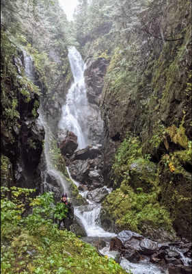
Hungry Bear Canyon
Hungry Bear is a fun intermediate canyon boasting an exciting 2-pitch 200' waterfall complete with a rooster tail. This canyon is v4a3 at moderate flows.
GETTING THERE
From Sultan, take the Sultan Basin Rd 13 miles north to Olney Pass. Register at the gated entrance to the Spada Lake area. Take South Shore Rd 4.5 miles to small turn out on the right hand side. An old over grown forest road is blocked by boulders. Park here.
APPROACH
Follow the gently rising overgrown road East for 1.2 miles, crossing multiple wash-outs. Before the road bends Southeast, leave the road and head South into the trees. Climb 600' following green flagging, until you reach an even more overgrown upper road. Follow this upper road Southeast for 700' until it brings you to a dismantled bridge crossing at Bear Creek. This is the drop-in point.
There's a small gear-up spot at the drop-in, but it may be more comfortable for larger groups to gear-in the forest before walking the upper road.
DESCENT
- R1 – 25' from single bolt DCR.
- R2 – 30' off bolts DCR. Some people may be comfortable down-climbing this rappel.
There is an exit just prior to the next obstacle, which is the headline two-stage rappel.
- R3 – 100' (approx.), bolts DCL. These bolts keeps rappellers DCL, which should be lower flow. An optional DCR redirect bolt keeps rappellers in the flow for more fun. Descend to the rebelay station (R4) at the base of the rooster tail, which can be seen from the top.
- R4 – 100' (approx.), rebelay bolts on canyon wall left, set back & high up from the lip (needs slight climb up to them).
In low & moderate conditions the rebelay should be out of the flow. In higher flows this station will be in the forceful spray of the rooster tail, so plan on moving your party through quickly.
It is possible for a proficient climber to scramble up the ramp canyon left just above R3. From there they can descend to a ledge above the rebelay station. There are sufficient natural anchors to set up a line from this location to the R4 anchor if a team member needs to ascend out of the flow from the R4 anchor.
- R5 - 20' (approx.) from single bolt DCL into slot. Bypass possible DCR.
- R6 - 6' was down-climbed in moderate flow. Rock pinch possible if needed in future. Bypass possible DCR.
- R7 - 60' (approx.) single bolt DCR.
Caution, the rock behind the water flow forms a narrow V-shaped crack. Stem across the flow to avoid putting your foot in the mouth of the shoe-eating bear who resides here.
Two further small down-climb drops follow. The first straightforward, the second may be protected from webbing around a log.
- R8 70' (approx.), single bolt DCR. The whole flow is channeled through a ledgey slot then down a series of ramps, forming rooster tails in places. Bridging is possible for the long-legged.
It is possible to exit the canyon after R8 by scrambling up hill canyon right, then descending on the ridge above the creek until intersecting with the old road. This is the only reasonable exit point (before the old road) after committing to R3.
- R9 - 30' from single bolt DCR.
- R10 - 30', down-climbed next to it, but could be rappelled if the flow seems appealing.
EXIT
Exit the creek where it intersects with the lower section of the old road. Follow the roadbed back to the parking location.
TRIP PROFILE
- Rappels: 10
- Longest Rappel: 100 feet
- Approach: 1.5 miles and 900 feet elevation gain
- Exit: 1 mile, losing 500 feet
- Time: 4 to 7 hours total
NOTES
- Hungry Bear Creek is rated v4a3 IV from mid-August through September.
- For the most updated information and recent trip reports from the community, visit Hungry Bear on ropewiki.com.
- Suitable Activities: Canyoning
- Seasons: Year-round, July, August, September, October
- Weather: View weather forecast
- Difficulty: Intermediate Canyon
- Length: 4.0 mi
- Land Manager: Morningstar NRCA
- Parking Permit Required: Discover Pass
- Recommended Party Size: 8
- Maximum Party Size: 12
- Maximum Route/Place Capacity: 12
There are no resources for this route/place. Log in and send us updates, images, or resources.
