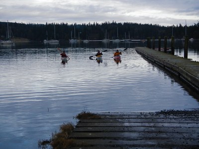
Mats Mats Bay
Sea kayak out through the harbor and scenic channel, watching for river otters on the right bank. Either paddle south past Colvos and Snake Rocks to Port Ludlow, or north for interesting rock formations to Oak Bay, brought to you by the incredible Puget Sound.
Launch Point
- Mats Mats Bay Boat Ramp. A porta potty is available at the boat ramp.
On the Water
Mats Mats Bay to Port Ludlow
8.0 nm round trip, Difficulty: Sea Kayak III
Paddle out through the harbor and scenic channel, watching for river otters on the right bank and then south past Colvos and Snake Rocks to Port Ludlow. There is no public restroom at Port Ludlow.
Mats Mats Bay to Oak Bay
up to 12 nm round trip, difficulty: sea kayak III
Paddle out through the harbor and scenic channel, watching for river otters on the right bank and then north for interesting rock formations to Oak Bay. There are also many nice beaches along the way to make for a good stop or turn around point. Many turn around before reaching Oak Bay.
notes
- An estimated tide level of +5 feet is required if launching from natural shore to avoid mud flats. A 0 ft tide is probably ok when launching from the boat ramp.
- Suitable Activities: Sea Kayaking
- Seasons: Year-round
- Weather: View weather forecast
- Difficulty: Sea Kayak III
- Length: 8.0 nm
- Land Manager: Port of Port Townsend
- Parking Permit Required: None
- Recommended Party Size: 12
- Maximum Party Size: 12
- Maximum Route/Place Capacity: 12
- MapTech Oak Bay to Commencement Bay No. 102
- Sea Trails North Hood Canal, Dosewallips to Port Ludlow WA105
This is a list of titles that represent the variations of trips you can take at this route/place. This includes side trips, extensions and peak combinations. Not seeing a title that fits your trip? Log in and send us updates, images, or resources.
- Mats Mats Bay to Port Ludlow
- Mats Mats Bay to Oak Bay
There are no resources for this route/place. Log in and send us updates, images, or resources.
