Harstine Island to McMicken Island
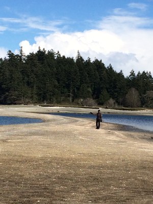
Hike an easy 1/2 mile through lush forest and wetlands to the rocky beach and bluffs of Harstine Island State Park in Mason County near Olympia. At low tide, proceed a little over a mile on the beach to the sand spit which will allow you to walk out to McMicken Island State Park. Although only 200 feet of elevation gain, the beach walk can be slow going.
GETTING THERE
Take Exit 104 off of I-5 onto US 101. Veer north at the intersection of US 101 and SR 8. Take the Olympic Highway (SR 3 exit) towards Shelton. Follow SR 3 east 11 miles, passing through downtown Shelton. Turn right onto E Pickering Rd. Follow E Pickering Rd for 3.3 miles then bear left onto Harstine Island Bridge Rd. Drive over the bridge and come to a "T" junction at 0.6 miles. Turn left on E North Island Dr and continue for 3 miles to a four-way junction at the island community hall. Turn right onto E Harstine Island Rd N and proceed for 1 mile, turning left on E Yates Rd. Follow the dirt road for 0.9 miles and turn right into Harstine Island State Park.
ON THE TRAIL
The trail system on Harstine Island consists of interconnected loops that pass through cedar swamps, through ravines and along the beach. The beach is exposed at low tide enabling hiking below the bluffs and a trip to McMicken Island. Observe tide pools and marine life.
notes
- Plan this hike during a low tide, so that you are hiking the beach at low tide and can walk the sandpit out to McMicken Island. Watch the tide closely, because the sand spit to McMicken Island will disappear at high tide.
- There's plenty to see starting from the beautiful trail through a lush ravine to the beach.
- At low tide it's possible to do more of the beach hiking on sand, rather than at high tide when it will be on the rocks.
- Both Harstine Island State Park and McMicken Island Marine State Park are managed by Jarrell Cove State Park.
Information for Leaders
The Mountaineers has a commercial use permit with Washington State Parks for all free and fee-based outings at state parks. Leaders should carry a print or digital copy of our commercial use permit to show rangers they may encounter.
- Suitable Activities: Day Hiking
- Seasons: Year-round
- Weather: View weather forecast
- Difficulty: Easy
- Length: 3.0 mi
- Elevation Gain: 200 ft
- 175 ft
- Land Manager: Jarrell Cove State Park
- Parking Permit Required: Discover Pass
- Recommended Party Size: 12
- Maximum Party Size: 12
- Maximum Route/Place Capacity: 12
- USGS Longbranch
This is a list of titles that represent the variations of trips you can take at this route/place. This includes side trips, extensions and peak combinations. Not seeing a title that fits your trip? Log in and send us updates, images, or resources.
- Hrastine Island
- Harstine Island State Park
- McMicken Island
- McMicken Island State Park
- McMicken Island Marine State Park
There are no resources for this route/place. Log in and send us updates, images, or resources.
