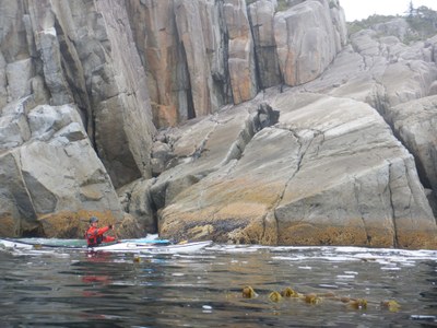
Hakai Protected Area
Formerly known as Hakai Recreational Area, this area spans the southern two thirds of Hunter Island south to the northern half of Calvert Island. It also includes Goose and Gosling Islands. It is an archipelago of awesome kayaking where you can choose to paddle inland or along the coast.
Launch points
- Klemtu: This is the Kitasoo/Xai'xais Nation territory. BC Ferries lands 2 km north of the village. Reach the village that has a store and lodge, take a taxi, walk, or kayak from the ferry landing. Launching from under the ferry dock is boulder strewn, but there is a ramp to the side that can be used once the ferry leaves (about an hour after its arrival). Questions about the village might be answered by calling 250-839-1096.
- Shearwater: The BC Ferry docks here. There is a marina, campground, laundry, and showers.
- Bella-Bella: The home of the Heiltsuk, and an unincorporated and Indian Reserve community located within Bella Bella Indian Reserve No. 1. The BC Ferry docks at McLaughlin Bay, 2 km south of the village. The landing at McLaughlin Bay is fine.
- Port Hardy: This is 54 nm from the southern boundary of the Hakai Protection Area, a journey all in itself.
Note that older guidebooks and previous travelers indicate an option for a "wet launch." BC Ferries no longer accommodate this.
on the water
The outer coast offers the most interesting, but challenging, conditions. Goose and Gosling Islands are a typical destination. Protection from weather can be achieved by staying in the inland waters. A classic trip is traversing the inland waterways between the ferry terminals, arriving at one and departing from another.
There are few current stations, but currents can be significant in the passages between islands.
Camping information is available from the BC Marine Trails website. Members can download detailed location information. This is an organization worth joining.
notes
- Guidebook: Kayak Routes of the Pacific Northwest Coast, 2nd ed. by Peter McGee (Greystone Books 2004).
- Guidebook: The Wild Coast, Volume 2: A Kayaking, Hiking and Recreational Guide for the North and Central B.C. Coast by John Kimantas (Whitecap Books Ltd, 2006).
- Magazine Article: "Navigating the Island Maze" Coast & Kayak Magazine (Spring 2014).
information for leaders
-
Considerations for travel to Canada
- Start by reviewing the latest regulations. Look for information on border crossing and travel to Canada on these websites:
- Everyone must have a passport or other valid ID like a NEXUS card.
- NEXUS cards can save a lot of time but only work if everyone in the car has one.
- Make sure your vehicle insurance is valid for Canada.
- Make sure your health insurance is valid for Canada.
- Border crossing regulations are strict in both directions. Know what you’re allowed to take and declare everything to avoid problems.
- You may be able to save time by checking alternate border crossings.
- See the Travel Industry Council of Ontario's 9 Travel Tips for Crossing the Canadian/U.S. Land Border blog post for some good tips on traveling to Canada.
- Start by reviewing the latest regulations. Look for information on border crossing and travel to Canada on these websites:
- Suitable Activities: Sea Kayaking
- Seasons: June, July, August, September
- Weather: View weather forecast
- Difficulty: Sea Kayak V
- Length: 100.0 nm
- Land Manager: Hakai Lúxvbálís Conservancy
- Parking Permit Required: None
- Recommended Party Size: 6
- Maximum Party Size: 8
- Maximum Route/Place Capacity: 12
- CHS No. 3784 - Kwakshua Channel to Spider Island and Namu Harbour
- CHS No. 3936 - Fitz Hugh Sound to Lama Passage
- CHS No. 3937 - Queens Sound
- CHS No. 3938 - Queens Sound to Seaforth Channel
There are no resources for this route/place. Log in and send us updates, images, or resources.
