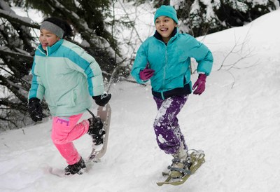
Gold Creek Basin
In winter, it's an easy to moderate snowshoe or ski tour through a wide, level valley in the shadow of Kendall Peak to the north and Rampart Ridge to the east near Snoqualmie Pass. In summer, enjoy a short walk around Gold Creek Pond, or a more adventurous journey up Gold Creek to as far as Alaska Lake.
getting there
Summer
Take Exit 54 off of I-90, turn left (north), and then turn right onto Forest Road 4832 that parallels the north side of I-90. Drive 1.0 mile, turn left on Gold Creek Road (Road 142), and turn left in 0.3 mile into the Gold Creek Pond parking lot (2,600 ft).
Winter
Take Exit 54 off of I-90 (2 miles east of Snoqualmie Pass), turn left, and cross under the interstate. A few hundred feet north of the interchange, turn right onto a narrow paved road and drive east paralleling I-90 one mile. Cars generally line both sides of this road, because the shoulder is the primary parking area for the long Gold Creek Sno-Park. Park at the end of the plowed road, near the small bridge over the stream connecting Mardee and Keechelus Lakes.
On the Trail
Gold Creek Pond Loop
1-mile loop, 100 feet of elevation gain, 2,700 ft high point,
DIFFCULTY: DAY HIKE, BEGINNER SNOWSHOE, U-XC1 BEGINNER UNGROOMED CROSS-COUNTRY SKi
Travel the loop around Golf Creek Pond in either direction on a combination of road, boardwalk, and trail. A short spur trail from the loop leads to the pond. A picnic area is near the end of the loop when hiked counterclockwise.
Gold Creek
10.2 MILES ROUND TRIP, 500 FEET OF ELEVATION GAIN, 3,100 FT HIGH POINT,
DIFFICULTY: DAY HIKE, BASIC SNOWSHOE, U-XC3 Intermediate ungroomed cross-country ski
Travel along Gold Creek Trail (No. 1314). The first 0.3 mile is on a gated driveway, the second 0.3 mile follows an abandoned road that dwindles to a rough trail. At 1.5 miles, enter the Alpine Lakes Wilderness and at 3 miles, cross Gold Creek and continue up the west side of the valley. Crossing Silver Creek at mile 3.5 and pass several dispersed campsites along the way. After crossing Alaska Creek at 4.5 miles, continue another half mile to a grassy meadow and a fork in the trail.
Alaska Lake
11.3 miles round trip, 1,600 feet of elevation gain, 4,213 ft high point
Hike the Gold Creek Trail 5.1 miles to is junction with the Alaska Lake Trail (H. 1314.1). Take the left fork and climb steeply for one mile through vine maple, slide alder, and finally a rock slide to Alaska Lake (4,200 ft). Take care in the spring and early summer when streams are running high or snow covers the route.
Joe Lake
13.3 miles round trip, 2,000 feet of elevation gain, 4,624 ft high point
Hike the Gold Creek Trail 5.1 miles to its junction with the Alaska Lake Trail. Continue straight, hiking along the creek for 2 miles ascending through avalanche debris and forest toward Alaska Mountain. From the southeast ridge of Alaska Mountain, a steep boot path on rocks and roots climbs to Joe Lake (4,624 ft).
Dungeon Knob
4.6 miles round trip, 2,100 feet of elevation gain
Dungeon Knob as a alternate destination leaving from the Gold Creek SnoPark. Dungeon Knob is a delightful winter snowshoe/scramble trip that leads to a knob at the end of forest service road 4832-141, underneath Dungeon Peak.
notes
- Snowshoe leaders, please limit elevation gain in order to keep this an Easy difficulty trip.
Information for Leaders
SCHEDULING & Permits
- Please note that Alaska Lake and Joe Lake are in the Alpine Likes Wilderness. Wilderness restrictions apply.
- If you are scheduling this as a non-course related activity, please limit your group size to the default party size. The maximum party size is for use by course field trips only, and includes both students and instructors. Group size maximums do not reflect how course field trips are run (in smaller groups of students and instructors), but allow for course leaders to register the course in our system.
-
Course Field trips
- Backpacking at Alaska and Joe Lakes is permitted up to a party size of 8.
- All our fee-based course field trips and seminars on U.S. Forest Service Land must be permitted through the Cle Elum Ranger District and listed on our Priority Use Permit.
.
- Suitable Activities: Backpacking, Cross-country Skiing, Day Hiking, Snowshoeing
- Snowshoeing Category: Beginner
- Seasons: Year-round
- Weather: View weather forecast
- View avalanche forecast.
- Difficulty: Easy/Moderate, U-XC 3 Intermediate Ungroomed
- Length: 10.0 mi
- Elevation Gain: 500 ft
- 3,100 ft
- Land Manager: Okanogan-Wenatchee National Forests
- Parking Permit Required: SnoPark Pass
- Recommended Party Size: 12
- Maximum Party Size: 60
- Maximum Route/Place Capacity: 60
- Green Trails Snoqualmie Pass Gateway No. 207S
- Green Trails Snoqualmie Pass No. 207
- USGS Chikamin Peak
- USGS Snoqualmie Pass
This is a list of titles that represent the variations of trips you can take at this route/place. This includes side trips, extensions and peak combinations. Not seeing a title that fits your trip? Log in and send us updates, images, or resources.
- Gold Creek
- Gold Creek Pond
- Gold Creek Pond Loop
- Lower Gold Creek Basin
- Upper Gold Creek Valley
- Alaska Lake
- Joe Lake
- Alaska & Joe Lakes
- Dungeon Knob
There are no resources for this route/place. Log in and send us updates, images, or resources.
