Backpack the Fjords of East Greenland
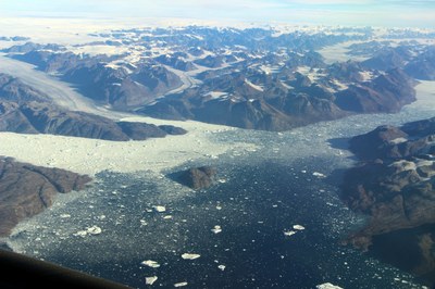
The fjords of East Greenland are some of the most vast, remote, and untouched landscapes on Earth. The area’s Karale, Tasiilaq, Qíngertivaq, Sermilik, and Johan Pedersen fjords challenge backpackers and hikers with no trails, few camps, and endless rugged terrain. But they reward with solitude, stunning granite peaks, massive calving glaciers, and waterways littered with icebergs.
Backpackers and hikers seeking challenge, solitude, and endless breathtaking landscapes will find plenty of opportunities in East Greenland.
One route starts at the Karale glacier, at the head of the Karale fjord. From here, backpackers and hikers can trek east along the southern coast of the Karale fjord to Nuuaartik Point, where they’ll be treated to views of Knud Rasmusen glacier across the sound to the north. Turning south and following the coast of Ikatek Straight, trekkers will then reach Bluie East Two, an abandoned WWII-era American airfield. From there, the route crosses a collection of streams at Suunigajik and then passes through the Tunup Kuua valley – surrounded on either side by mountains – to reach Tasiilaq fjord. The route then follows the eastern shores of the very deep Tasiilaq fjord, with the peaks of Fox’s Jaw towering over the head of the fjord to the north. Trekkers have the option to explore a plateau to the east, high above the fjord, before finishing the route at the head of the fjord. From there, trekkers can optionally head inland, ascending a glacier moraine to the remote Tasiilaq Mountain Hut.
Another route starts at the head of either Tasiilaq fjord or the very narrow Qíngertivaq fjord nearby. Heading inland, trekkers pass alongside the Caledonian Alps and Fox’s Jaw (if starting from Tasiilaq fjord) or tackle Sun Gate Pass (if starting from Qíngertivaq fjord). With either branch, trekkers eventually reach the immense Sermilik fjord. Helheim glacier at the head of the fjord advances approximately 60 meters per day, littering the fjord with thousands of icebergs. Heading south along the eastern shore of Sermilik fjord, with constant views of the fjord and its icebergs to the west, trekkers eventually head inland, passing south through a valley to reach the tiny village of Tinit.
The final route – Johan Pedersen fjord – offers just a single day hike. But that hike offers trekkers views of the Greenland Ice Sheet, the 2nd -largest ice mass on Earth. Covering 80% of Greenland, the ice sheet stretches across 656,000 square miles – approximately 3 times the size of Texas – and is 1.9 miles deep at its thickest point.
Getting there:
The main gateway to East Greenland is the town of Kulusuk, with regular flights to/from Reykjavik’s international airport (KEF). Charter boats or helicopters are used to travel from Kulusuk to the primary backpacking and hiking areas.
- Suitable Activities: Backpacking, Day Hiking, Global Adventures
- Seasons: June, July, August, September
- Weather: View weather forecast
- Difficulty: Very Strenuous
- Land Manager: Land Manager Varies
- Parking Permit Required: see Land Manager
- Recommended Party Size: 12
- Maximum Party Size: 12
- Maximum Route/Place Capacity: 12
There are no resources for this route/place. Log in and send us updates, images, or resources.
