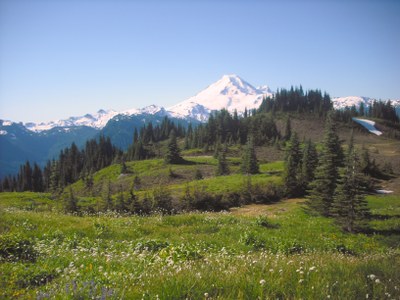
Excelsior Ridge (East High Divide Trail)
This roughly 10 mile hike with over 3,000 feet of elevation gain starts at the Welcome Pass trailhead. From the pass, you can hike out the ridge and back or continue on to complete the Grand Traverse. Either way, Excelsior Ridge delivers an incredible ridge walk through wildflowers with Mount Baker and Mount Shuksan seemingly close enough to touch.
Getting there
Drive to the Welcome Pass Trailhead (2,500 ft) at the end of Forest Road 3060, a short gravel spur just off of SR-542. If you're hiking the Grand Traverse, leave a car at the West High Divide Trailhead, Trail No. 630, just off of SR-542 on the way to the Welcome Pass Trailhead.
on the trail
Welcome Pass
Ascend 2,000 feet in seemingly endless switchbacks on through forest before breaking out suddenly into the meadows at Welcome Pass. Day Hiking North Cascades says "more than 60-count 'em!", one of our leaders counted 88! Turn left (east) on the East High Divide Trail (No. 630) and hike as farther along the ridge as you wish. Don't trip over your feet watching the views, which are just that good! Mount Baker and Mount Shuksan seem close enough to touch just across the valley, and flowers are everywhere in summer.
Grand Traverse
Ascend 2,000 feet in seemingly endless switchbacks on through forest before breaking out suddenly into the meadows at Welcome Pass. Day Hiking North Cascades says "more than 60-count 'em!", one of our leaders counted 88! For the Grand Traverse, turn left (east) on the East High Divide Trail (No. 630) and hike 5 mi farther along the ridge. Don't trip over your feet watching the views, which are just that good! Mount Baker and Mount Shuksan seem close enough to touch just across the valley, and flowers are everywhere in summer. Take a short walk up 5,699-foot Excelsior Mountain before heading down the West High Dived Trail.
The Grand Traverse could be made moderate by starting at Canyon Creek trailhead and hiking the other direction (east), still 10 mi, but only 1,240 feet of elevation gain. The Canyon Creek trailhead is at the end of Forest Road 31 off of State Route 542. This makes for a shorter hike with a less steep descent, but a much longer car shuttle.
- Suitable Activities: Day Hiking
- Seasons: July, August, September
- Weather: View weather forecast
- Difficulty: Moderate, Strenuous
- Length: 10.0 mi
- Elevation Gain: 3,070 ft
- 5,930 ft
-
Land Manager:
Mount Baker-Snoqualmie National Forest
Mount Baker Wilderness, Mount Baker Ranger District (MBSNF)
- Parking Permit Required: Northwest Forest Pass
- Recommended Party Size: 12
- Maximum Party Size: 12
- Maximum Route/Place Capacity: 12
- Green Trails Mt Baker No. 13
- Green Trails Mt Shuksan No. 14
- Green Trails Mount Baker Wilderness Climbing No. 13SX
- Trails Illustrated North Cascades National Park
This is a list of titles that represent the variations of trips you can take at this route/place. This includes side trips, extensions and peak combinations. Not seeing a title that fits your trip? Log in and send us updates, images, or resources.
- Excelsior Ridge
- Excelsior Ridge Traversse
- East High Divide Trail
- Welcome Pass
There are no resources for this route/place. Log in and send us updates, images, or resources.
