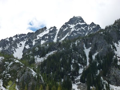
Sherpa Peak/Northeast Couloir
A moderate intermediate spring climb in the remote, alpine setting of the Alpine Lakes Wilderness. Expect snow and ice, and one short pitch of low Class 5.
Geting There
Drive US-2 east to Leavenworth. Just before entering town, turn right on Icicle Creek Road. Follow Road 8.5 miles to Bridge Creek Campground. Turn left and drive through campground, cross the river to Eightmile Creek Road (Forest Road 7601). Drive 4 miles to start of Lake Stuart Trailhead (3,600 ft).
APPROACH
Begin at the Lake Stuart-Colchuck Lake Trail (No. 1599). At about 2.2 mi (4,500 ft) there is a fork. The left goes to Colchuck Lake, right goes to Lake Stuart. Continue on the Stuart Lake trail through the beaver meadows. In another 1.5 mi, the first switchback (right) is reached. Depart the trail here to the left (south) finding an obscure climbers' trail.
Cross the Stuart Lake creek over logs. This trail has not been maintained in decade. It is riddled with blowdowns, re-routes, questionable cairns, and is hard to follow. Generally follow along Mountaineers Creek, with it on your left. Do not follow the cairns into the boulder field (4,675 ft at UTM NAD27 10 T 661036 5261934), but rather, stay low along the creek.
Follow Mountaineers Creek until it forks (both forks head up hill). Take the left fork and follow it to a flat area (~5,800 ft). Bivy on snow or rocks.
ASCENT ROUTE
Ascend moderate slopes to an obvious couloir. Ascend the couloir which may be snow or ice up to 50 degrees. Place pickets as needed. At the top of the couloir scramble up and right to the balanced rock at the summit, finishing with one, short 5.0 pitch.
DESCENT ROUTE
Descend the climbing route, or descend around to Sherpa Pass and downclimb from here to camp.
TRIP PROFILE
| SEGMENT | MILES | ELEVATION GAIN (FT) | TIME(HR) |
|---|---|---|---|
| Trailhead to Camp | 6.0 | 2,200 | 4 |
| Camp to Summit | 2.0 | 2,800 | 6 |
| Summit to Trailhead | 8.0 | 7-8 |
EQUIPMENT
Ice axe and 2nd tool. Pickets for running belay. Provisional ice screws. Small alpine rack up to 3 inches.
NOTES
- No Enchantments Permit is required to camp in this area.
- Depending on snowpack, the approach may be via climbers trail as described, or over snow.
- Suitable Activities: Climbing
- Climbing Category: Intermediate Alpine
- Seasons: April, May, June
- Weather: View weather forecast
- View avalanche forecast.
- Difficulty: Intermediate Mountaineering Climb
- Length: 16.0 mi
- Elevation Gain: 5,000 ft
- 8,605 ft
-
Land Manager:
Okanogan-Wenatchee National Forests
The Enchantments, Wenatchee River Ranger District (OWNF)
- Parking Permit Required: Northwest Forest Pass
- Recommended Party Size: 4
- Maximum Party Size: 8
- Maximum Route/Place Capacity: 8
- USGS Cashmere Mtn
- Green Trails Alpine Lakes East (Stuart Range) No. 208SX
- USGS Mount Stuart
- USGS Enchantment Lakes
There are no resources for this route/place. Log in and send us updates, images, or resources.
