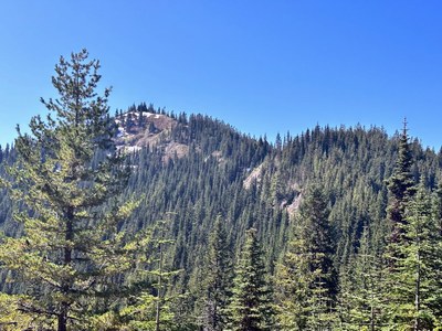
Dixon Mountain
A moderate scramble located just south of Mount Rainier National Park with three approach options.
Getting There
Drive toward the Mount Rainier National Park's Nisqually Entrance on SR-706, and ~3.5 miles past Ashford (0.2 miles past Milepost 10), turn right on Skate Creek Road (Forest Road 52, signed “Kernahan Road”). Travel ~14 miles and turn left on Forest Raod 5260. If you cross the bridge over Skate Creek, you have gone too far. From Forest Road 5260 there are three starting points and three routes.
Southwest Ridge
After turning off Forest Road 52, drive Forest Road 5260 for 0.75 mile (go past Johnson Creek), where the road curves before heading northeast up Johnson Creek. Park here (2,350 ft).
North Ridge
After turning off Forest Road 52, drive Forest Road 5260 3.1 miles and park at any convenient place along the road (3,150 ft).
Borrow Pit
After turning off Forest Road 52, drive Forest Road 5260 5.7 miles to near the pit (4,040 ft). Only attempt the final 2 miles of Forest Road 5260 with a very high-clearance vehicle. Erosion has not been kind to this "road." There are deep ruts in places, lots of very sharp rocks, and alders encroach when attempting to avoid the ruts and deep troughs. If the road becomes impassable park and walk the remainder of the road. If entire road is driveable, park in a wide-open area beneath the Borrow Pit (quarry).
approach & Ascent
Southwest Ridge
4.0 miles round trip, 3,100 feet of elevation gain, Difficulty: Strenuous 2, Technical 1
The route follows the west-southwest ridge of Dixon Mountain. From the parking spot at 2,350 ft, find the best route up the ridge. At ~4,500 ft, leave the ridge on the left and head into a basin (traveling easterly). Regain the summit ridge, heading slightly southeast, and follow the ridge northeast to the summit.
North Ridge
5.5 miles round trip, 2,300 feet of elevation gain, Difficulty: Strenuous 2, Technical 1
In the parking spot at 3,150 ft, set a GPS point so it's easy to find it on the return. Travel easterly following the best terrain to the borrow pit at 4,040 ft. There are many blowdowns on this slope above the suggested route, and it is best to stay in the heavy forest for easier travel. It may be easier to intersect the road at 3,850 ft and follow it to the borrow pit. From here, follow the route description for the Borrow Pit.
Borrow Pit
4.0 miles round trip, 1,200 feet of elevation gain, Difficulty: Strenuous 2, Technical 1
This is the easiest of the routes. From the borrow pit walk the road back a few yards and take obvious road to left (south). In about fifty yards take the right (west) fork, which ends shortly. There's no sign, but the trail takes off on an obvious tread, heading nearly south from the end of the short dead-end road. The trail can be followed to the summit. In places the trail is badly overgrown with huckleberries, azaleas, mountain ash, and some fir. Downfall is minimal and not difficult to negotiate.
- Suitable Activities: Scrambling
- Seasons: July, August, September
- Weather: View weather forecast
- Difficulty: Technical 3, Strenuous 3
- Length: 5.5 None
- Elevation Gain: 3,100 ft
- 5,134 ft
-
Land Manager:
Gifford Pinchot National Forest
Cowlitz Valley Ranger District (GPNF)
- Parking Permit Required: None
- Recommended Party Size: 12
- Maximum Party Size: 12
- Maximum Route/Place Capacity: 12
- USGS Tatoosh Lakes
- USGS Wahpenayo Peak
- Green Trails Randle No. 301
There are no resources for this route/place. Log in and send us updates, images, or resources.
