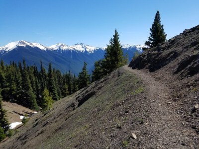
Deer Ridge
Hike the ridge from Slab Camp up to Deer Park on the north side of the Olympics. Consider visits to Blue Mountain and Maiden Peak or a loop trip with Three Forks, Gray Wolf, and Slab Camp Creek Trails.
getting there
Drive US-101 2.5 miles west of Sequim and turn left onto Taylor Cutoff Road. Turn right onto Lost Mountain Road in 2.6 miles and then left onto Forest Road 2870 in 2.6 miles. Drive 1 mile and take the right fork onto Forest Road 2875. Continue 3.5 miles to the Slab Camp Trailhead (2,550 ft).
on the trail
Deer Ridge to Deer Park
10.0 miles round trip, 2,800 feet of elevation gain
Trail No. 846 starts out in the Olympic National Forest on an old road bed. At 1.5 miles the elevation gain begins in earnest. Weather permitting, views to the south begin about 2.7 miles in. At 3.3 miles (4,800 ft) enter Olympic National Park. At 4.9 miles reach the Deer Park campground at 5,350 ft and the end of the trail.
Deer Ridge, Three Forks, Gray Wolf Loop
16.5-mile loop, 5,262 feet of elevation gain
Hike west on the Deer Ridge Trail, south on the Three Forks Trail, east on the Gary Wolf Trail, and north on the Slab Camp Creek Trail to make the loop. Here's a suggested two-day itinerary:
Day 1: Starting at Deer Ridge/Slab Creek Trailhead, hike west along Deer Ridge with a climb of 3,000 feet over 4.5 miles to the edge of Deer Park. Deer Park is a campground accessible by car (via a long, narrow, winding dirt road with few turnouts) so we will have company. This is a great place to have a snack or lunch and contemplate the views. According to most sources, there is no water at Deer Park but some trip reports state there is a small creek near the ranger station. Be safe and bring plenty of water or confirm with a ranger the status of a water source. After enjoying views, hike down Three Forks Trail for 4 miles and 3,200 feet of elevation loss to camp to Three Forks camp. The beginning of this trail is the most steep so hiking polls are recommended. Nearby Grey Wolf camp is across the river ~0.3 miles. Both camps have lovely sites along the Grey Wolf River with the constant of rushing river that can be quite vigorous in early summer. Total stats for the day: 8.4 miles with 3,040 feet of elevation gain, and 3,360 feet of elevation loss.
Day 2: Cross a sturdy bridge and hike west along the Grey Wolf River Trail 5 miles on an up and down route with total elevation gain of 2,100 feet and elevation loss of 2,700 feet. Along the way pass Camp Tony, another great spot for a snack. At the junction with Slab Camp Creek Trail, turn left (northwest) and hike uphill 1,200 feet of elevation gain over 2.7 miles to complete the loop. Total stats for the day: 7.75 miles with 2,220 feet of elevation gain, and 1,800 feet of elevation loss.
notes
- The Deer Ridge Trail is dry in late summer so bring plenty of water.
- Consider adding a trip up Blue Mountain. It's a steep ½ mile up the road from Deer Park. There are 360° views of the surrounding Olympics on a clear day!
- Consider adding a trip from Deer Park to Maiden Peak. It's 9 miles round trip with 2,100 feet of elevation gain.
- Suitable Activities: Backpacking, Day Hiking
- Seasons: May, June, July, August, September, October
- Weather: View weather forecast
- Difficulty: Strenuous
- Length: 10.0 mi
- Elevation Gain: 2,800 ft
- 5,350 ft
-
Land Manager:
Olympic National Forest
Hood Canal Ranger District (ONF)
- Parking Permit Required: Northwest Forest Pass
- Recommended Party Size: 12
- Maximum Party Size: 12
- Maximum Route/Place Capacity: 12
- Green Trails Olympic Mountains East No. 168S
- Custom Correct Gray Wolf - Dosewallips
This is a list of titles that represent the variations of trips you can take at this route/place. This includes side trips, extensions and peak combinations. Not seeing a title that fits your trip? Log in and send us updates, images, or resources.
- Deer Park via Deer Ridge
- Deer Ridge & Deer Park
- Deer Ridge to Deer Park
- Deer Ridge & Blue Mountain
- Deer Park to Maiden Peak
- Deer Ridge, Three Forks, Gray Wolf Loop
There are no resources for this route/place. Log in and send us updates, images, or resources.
