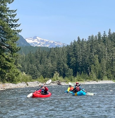
Cowlitz River: La Wis Wis to Cowlitz Falls
A low stakes float through beautiful moss-covered mountain canyons with forest above and views of Mt. Rainier. Most white water is within first couple miles of the put in and predominantly class II-.
FLOW
- USGS Gauge: Cowlitz River at Packwood, WA - 14226500
- 600-900 CFS: low but runnable
- 900-2,000 CFS: runnable, may have class III rapid at higher flows
PUT-INS & TAKE-OUTS
- La Wis Wis Campground: A Northwest Forest Pass is required. Heading east on Highway 12 from Randle, the turn-off for La Wis Wis Campground is at mile 138, just before the junction with Highway 123. Follow the campground road 0.5 miles down the hill, but instead of entering the campground turn right and then take an immediate left to the day-use picnic area. In the off season the campground may be closed and you will have to walk from the gate.
- Packwood Bridge: At the Skate Creek Road bridge in Packwood on river left. Park at Packwood Cowlitz River Public Access Point. From La Wis Wis Campground this makes for a 7.7 mile float.
- Cora Bridge: Take out on river right at the Highway 12 bridge in Cora. To park, turn north on E Carr Road, then an immediate right onto a dirt road. From Packwood this reach is 10 miles, making for an 18 mile reach from La Wis Wis Campground.
- Cowlitz Falls Campground: State Parks Pass required and can be purchased at the kiosk. Take out on river right onto the wide boat ramp. This reach adds 15 miles from Cora of lazy braided glacial river through some idyllic pastoral scenes. From La Wis Wis Campground this makes for about 33 river miles and could be done as a 1 or 2 night overnight.
ON THE RIVER
Most of the fun riffles come in the first couple of miles from La Wis Wis Campground. They are usually class II- but there is one that could become class III at higher flows. For day trips, the reach from La Wis Wis to Packwood or La Wis Wis to Cora is recommended.
For an extended trip with camping along the way, continue all the way to Cowlitz Falls Campground. Don't let the name mislead you. The falls have long been inundated when the dam was built. The river flattens out and meanders from Packwood down. From Cora to Cowlitz Falls it flattens out some more and is a gentle float most of the way, affording a relaxing float through the wide river valley with nice views and passing some farmland.
NOTES
- Learn more on American Whitewater's web page: Cowlitz River: La Wis Wis Campground to Packwood
- Suitable Activities: Packrafting
- Seasons: Year-round, March, April, May, June, July
- Weather: View weather forecast
- Difficulty: Class II River
- Length: 35.0 mi
- Land Manager: Land Manager Varies
- Parking Permit Required: Northwest Forest Pass
- Recommended Party Size: 8
- Maximum Party Size: 12
- Maximum Route/Place Capacity: 12
This is a list of titles that represent the variations of trips you can take at this route/place. This includes side trips, extensions and peak combinations. Not seeing a title that fits your trip? Log in and send us updates, images, or resources.
- Cowlitz River: La Wis Wis to Packwood
- Cowlitz River: La Wis Wis to Cora
- Cowlitz River: Packwood to Cowlitz Falls
There are no resources for this route/place. Log in and send us updates, images, or resources.
