Cispus River: FR28 Bridge to Copper Canyon Creek
A nice excursion through the Gifford Pinchot National Forest abounding with wildlife. The reach can be divided into two sections, an 8 mile Class II stretch and an 8.5 mile class III run that brings you to Lake Scanewa.
FLOW
- USGS Gauge: Cispus River AB Yellowjacket Creek Near Randle
- 800 - 2,000 CFS: runnable
- 2,000 - 4,000 CFS: high runnable
TAKE-OUT
- Copper Canyon Creek: Starting from the town of Randle at Highway 12 mile marker 115, take Cispus Road south across the Cowltiz River and continue for one mile to the fork of FR 25 and FR 23. Take the right fork on FR 25 and head 7.8 miles to Huffaker Bridge which crosses the Cispus River. Continue across the bridge and immediately take a right turn down the forest road that parallels river left. After 1.6 miles, take the left fork and continuing parallel the river on river left. Head 4.7 miles down the forest road on river left to a pull-out just past a small creek (this is Copper Canyon Creek). Here you will find a spur road (the 340 road) that leads to the river providing boater access to the reservoir.
PUT-INS
- Crystal Creek Bridge: This is the put in for a shorter class III section. From Huffaker Bridge continue across the bridge and immediately take a right turn down the forest road that parallels river left. Head 1.6 miles down this road and then take the right fork to the Crystal Creek Bridge. The access is steep but okay for packrafts.
- Twin Cedars: From Huffaker Bridge, head continue upstream along river left. Take the left turn onto FR 76 to stay along the river following it for 0.8 mile to a site just past Iron Creek where the river comes close to the road; this site is known as Twin Cedars. There is a small pull-out with a twin pair of majestic cedar trees along the river bank and a couple larger pull-outs immediately upstream.
- NF28 Bridge: For more class II floating you can continue up FR 76 to the FR 23 bridge which crosses the river and is considered the traditional dividing point between the upper and lower run. Access is on river right. There is a large pull out on the north side of the bridge.
ON THE RIVER
FR28 BRIDGE TO TWIN CEDARS
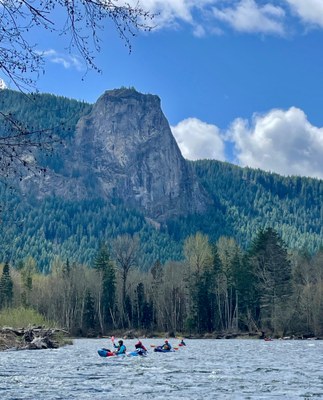
Starting from the FR 28 bridge (river mile 17.5), the first 4 river miles are characterized by braided channels and shifting gravel bars as the river cuts through a wide river valley with sweeping views of Tower Rock. The character changes dramatically once Tower Rock is behind you as the river becomes a narrower channel hemmed in by tall 2nd growth forest on both sides. There are fewer eddies and more whitewater rapids in this lower stretch. Wood hazards abound both midstream and along the banks. You will encounter some private property along this first half which passes under the shadow of Tower Rock. This is a 7.9 mile class II run.
TWIN CEDARS TO COPPER CANYON CREEK
This reach starts about a mile upstream of the Iron Creek Campground and features several class III rapids and ledge drops, and . The put-in is at Twin Cedars access (river mile 9.2). This reach has a lot of engaging rapids and a handful of holes that could easily capsize a packrafter. One of the nice things about this section is all the rapids have relatively easy lines that make it a great training stretch for those just getting into intermediate whitewater. The take out is on river left and is private land owned and managed by Port Blakely, at river mile 1.0. This is a class III reach of 8.5 river miles.
NOTES
- Avg. Gradient: 24 feet/mile
- There are many primitive camp sites in the area and developed campgrounds such as Cowlitz Falls Campground.
- Makes for a nice weekend running class II one day and class III the next. Many waterfalls in the area.
- Suitable Activities: Packrafting
- Seasons: Year-round
- Weather: View weather forecast
- Difficulty: Class III River, Class II River
- Length: 16.5 mi
- Land Manager: Land Manager Varies
- Parking Permit Required: see Land Manager
- Recommended Party Size: 7
- Maximum Party Size: 12
- Maximum Route/Place Capacity: 12
This is a list of titles that represent the variations of trips you can take at this route/place. This includes side trips, extensions and peak combinations. Not seeing a title that fits your trip? Log in and send us updates, images, or resources.
- Cispus River: Twin Cedars to Copper Canyon Creek
- Cispus River: FR23 to Twin Cedars
There are no resources for this route/place. Log in and send us updates, images, or resources.
