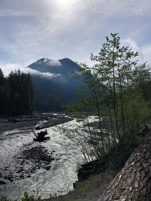
Carbon River Road
After repeated washouts, Mount Rainier National Park turned the Carbon River Road into a trail. This is a great opportunity to hike in low-elevation old growth forest. The hike to Ipsut Creek Camp is moderate at 10 miles round trip and 600 feet of elevation gain.
Emergency closure
As of April 14, 2025, the Fairfax bridge at milepost 11.5 has been closed until further notice. This closes access to Mount Rainier National Park's Mowich Lake and Carbon River entrances. Check WSDOT.com for status.
This hike is in Mount Rainier National Park. The National Park Service preserves unimpaired the natural and cultural resources and values of the National Park System for the enjoyment, education, and inspiration of this and future generations. The National Park Service cooperates with partners to extend the benefits of natural and cultural resource conservation and outdoor recreation throughout this country and the world.
All participants should orient themselves to the unique geologic hazards at Mt. Rainier, an active volcano.
getting there
From SR-410 in Buckley, head south on SR-165. After crossing the Carbon River Gorge Bridge, bear left and proceed to the Mount Rainier National Park boundary (1,900 ft).
on the trail
After repeated washouts, Mount Rainier National Park turned the Carbon River Road into a trail. This is a great opportunity to hike in low-elevation old growth forest.There are several hikes possible along the Carbon River Road from the National Park Boundary. Bikes are permitted on the Carbon River Road, so mountain biking the portion of any hike makes for a quicker trip.
Old Mine Trail
3 miles round trip, 270 feet of elevation gain, 2,140 ft high point
Hike or bike the Carbon River Road 1.2 miles to a river view point. Turn right and hike the Old Mine Trail 0.8 mile to an old mine.
Green Lake & Ranger Falls
10.4 miles round trip, 1,720 feet of elevation gain, 3,215 ft high point
Hike or bike 3.1 miles on the Carbon River Road and turn right on the Green Lake Trail. Hike 0.9 miles to a short side trip to Ranger Falls and then 0.8 miles further to Green Lake.
Chenuis Falls
8.4 miles round trip, 400 feet of elevation gain, 2,200 ft high point
Hike or bike 3.6 miles on the Carbon River Road to a picnic area. Bear left, cross the Carbon River on a footbridge and hike 0.2 miles to Chenuis Falls.
Ipsut Creek Camp
10.2 miles round trip, 600 feet of elevation gain, 2,400 ft high point
Hike or bike 5.1 miles on the Carbon River Road to Ipsut Creek Camp. Hike the short side trip to see Ipsut Falls.
Carbon Glacier
18 miles round trip, 1,640 feet of elevation gain, 3,200 ft high point
Hike or bike 5.1 miles on the Carbon River Road to Ipsut Creek Camp. Hike east on the Wonderland Trail to the Carbon River Camp and views of the Caron Glacier.
Information for Leaders
SCHEDULING & PERMIT INFORMATION
- If you are scheduling this as a non-course related activity, please limit your group size to the default party size. The maximum party size is for use by course field trips only, and includes both students and instructors. Group size maximums do not reflect how course field trips are run (in smaller groups of students and instructors), but allow for course leaders to register the course in our system.
- If you are scheduling a course field trip, please contact our Member Services Team to confirm the field trip and any permitting regulations.
- Suitable Activities: Backpacking, Bikepacking, Day Hiking
- Seasons: May, June, July, August, September, October, November
- Weather: View weather forecast
- Difficulty: Moderate, Easy, Bikepacking Gravel II
- Length: 10.0 mi
- Elevation Gain: 600 ft
- 2,400 ft
- Land Manager: Mount Rainier National Park
- Parking Permit Required: National Park Entrance Fee
- Recommended Party Size: 12
- Maximum Party Size: 24
- Maximum Route/Place Capacity: 12
- Green Trails Mt Rainier West No. 269
- Green Trails Mount Rainier Wonderland No. 269SX
This is a list of titles that represent the variations of trips you can take at this route/place. This includes side trips, extensions and peak combinations. Not seeing a title that fits your trip? Log in and send us updates, images, or resources.
- Old Mine Trail
- Carbon River Road & Old Mine Trail
- Green Lake & Ranger Falls
- Carbon River Road, Green Lake & Ranger Falls
- Chenuis Falls
- Carbon River Road & Chenuis Falls
- Ipsut Creek Camp
- Carbon River Road to Ipsut Creek Camp
- Carbon Glacier
- Carbon River Road to Carbon Glacier
There are no resources for this route/place. Log in and send us updates, images, or resources.
