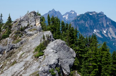
Beckler Peak
A moderate, 8 mile round-trip hike with 2,263 feet of elevation gain. This hike takes you through old-growth forest and features views of surrounding peaks - Glacier Peak, the Monte Cristo Range, and many more.
driving directions
Take Highway 2 to Skykomish. Approximately 2 miles after the ranger station, turn left onto Forest Road 6066 follow it (stay right) to the Beckler Peak trailhead at 2,800 ft.
on the trail
The hike begins on an old road and continues through a beautiful forest. A shimmering white granite ridge leads to the non-technical East summit, and technical scrambling/climbing paths to the Middle and West summits. All three summits provide grand 360 degree views of the vast expanse of the Wild Sky Wilderness, Mount Baring, Merchant Peak and Eagle Rock to the west, the Monte Cristo Peaks to the north and Glacier Peak to the northeast. Mount Fernow keeps close company to the east. To the south, the Tye River winds its way to its confluence with the Beckler River, and in the distance the peaks of the central Alpine Lakes, Mount Daniel and Chimney Rock are visible. On clear days Mount Rainier may show itself 65 miles to the south.
notes
- Despite significant elevation gain, the summit is easily attained and provides an incredible effort-to-reward ratio because of the remarkably even gradient. The East summit can hold only half a dozen people at a time, so an early start is advised.
- Be careful of the steep drop off to the north edge of the summit.
- Suitable Activities: Day Hiking
- Seasons: July, August, September, October
- Weather: View weather forecast
- Difficulty: Moderate
- Length: 8.0 mi
- Elevation Gain: 2,263 ft
- 5,063 ft
-
Land Manager:
Mount Baker-Snoqualmie National Forest
Wild Sky Wilderness, Skykomish Ranger District (MBSNF)
- Parking Permit Required: Northwest Forest Pass
- Recommended Party Size: 12
- Maximum Party Size: 12
- Maximum Route/Place Capacity: 12
- Green Trails Skykomish No. 175
- USGS Skykomish
- Green Trails Alpine Lakes West (Stevens Pass) No. 176S
There are no resources for this route/place. Log in and send us updates, images, or resources.
