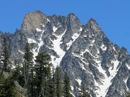
Argonaut Peak/South Route
A long, hard scramble in the Alpine Lakes Wilderness with 4th class crux near the summit that is often protected. It's 19 miles, over 4,800 feet of elevation gain, and at 8,453 ft, 66th on the Bulger List.
getting there
From SR 970 turn onto Teanaway River Road bearing right as it becomes North Fork Teanaway River Road. Just past 29 Pines Campground, it becomes a dirt road, Forest Road 9737. Just before the bridge over Beverly Creek, turn right on Forest Road 9737-112, and drive 1.4 mi to the Beverly Creek trailhead at the road's end (3,600 ft).
Approach & Ascent
From the Beverly Creek Turnpike trailhead, hike the Beverly Creek and Fourth Creek trails 6 miles to Ingalls Creek which must be forded. There is good camping here. From Ingalls Creek Trail, ascend straight uphill, find game trails, take path of least resistance, avoiding brush at the right. At 5,200 ft cross brush to reach open slopes, ascend left side of large drainage gully to 6,600 ft and then climb the gully. At 7,100 ft, the gully splits into two large gullies; the standard route is the left gully, but right gully goes too. Ascend to right side of summit face, and climb the final crux section, a 50-foot gully with chockstone at its top (Class 4), to gain the east ridge. Follow this ridge west to the summit.
Descent
Rappel the 50-foot gully and descend route.
- Suitable Activities: Climbing
- Climbing Category: Basic Alpine
- Seasons: April, May, June, July, August, September, October
- Weather: View weather forecast
- Difficulty: Basic Alpine Climb
- Length: 19.0 mi
- Elevation Gain: 7,600 ft
- 8,453 ft
-
Land Manager:
Okanogan-Wenatchee National Forests
Alpine Lakes Wilderness, Wenatchee River Ranger District (OWNF)
- Parking Permit Required: Northwest Forest Pass
- Recommended Party Size: 12
- Maximum Party Size: 12
- Maximum Route/Place Capacity: 12
- Alpine Lakes Wilderness (ALPS)
- USGS Mount Stuart
- Green Trails Mt Stuart No. 209
- Green Trails Alpine Lakes East (Stuart Range) No. 208SX
- USGS Enchantment Lakes
- Trails Illustrated Alpine Lakes Wilderness
There are no resources for this route/place. Log in and send us updates, images, or resources.
