Trip
Day Hike - Leslie Gulch & Juniper Gulch Trail
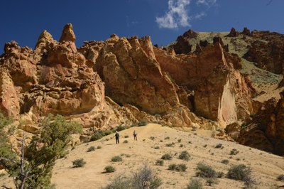
Explore nature and photograph spectacular high desert scenery, spring wildflowers, wildlife, dramatic unique eroded rock formations in Leslie Gulch within an ancient volcanic caldera and night sky viewing in SE Oregon's Owyhee Canyonlands (remniscent of NV Red Rock SP and UT canyonlands).
- Wed, May 19, 2021 — Sat, May 22, 2021
- Seattle Photography Committee
- Day Hiking, Exploring Nature, Photography
- Adults
- Moderate
- Mileage: 15.0 mi
- Elevation Gain: 1,500 ft
- 2 (6 capacity)
- Cancellation & Refund Policy
Updated 5/13:
Meet at Slocum Creek campground: 8:30am for Wed-Fri hikes, and optional Friday hike TBD. Tuesday afternnon (betw 2-4pm): for optional hike, on your own or with group
Best local road access is from Rockville T-shaped junction at the Rockville School, where you will head left toward Succor Creek for another 1.8 miles. Then turn left on the gravel for Leslie Gulch. It descends through stunning rock formations to the Owyhee River roughly 14.5 miles in. Medium clearance or higher vehicle recommended.
Do not drive road south from Succor Creek State Park, which may be difficult driving or impassible when wet conditions; OK if dry road
Updated 5/13:
For members only. Minimum 3 participants.
SUBMIT LEADER PERMISSION REQUESTS VIA LINK FOR REVIEW, WHEN REGISTRATION OPENS, Email leader with recent moderate hiking experience and interests in this trip (photo, naturalist, hiking only). Leader is unable to respond to permission requests while traveling remotely 4/23-27.
Leader will email pre-trip details to participants at least a week prior to trip.
Covid-19: We will follow all Mountaineers Protocol--each participant is to bring a cloth facemask and hand sanitizer. The mask must to worn when within 6' of others.
Leisurely pace group hikes for short to extended photo opp stops and nature enjoyment of dramatic scenery, unique eroded rock formations (spires and honeycombed welded volcanic tuff), rare and abundant spring wildflowers, and wildlife (birds, bighorn sheep, snakes, lizards, insects) in the ancient Mahogany Mountain caldera created by the "Yellowstone Hotspot." Options for early and late light photography near camp. If you're looking for a faster paced hike or solo hiking, please consider joining a trip that better matches your expectations.
Primitive camping at Slocum Creek CG (Leslie Gulch) or at Succor Creek State Park. Pack in vehicle 1 gal water per person for each day for trail and camp use.
Be aware of approx travel times to Leslie Gulch: from Boise 2 hours; from Seattle 8-9 hours (via I82, I84, ID95); from Portland approx 7-8 hours (via I84, ID95).
Day hikes approx 5-7 miles/day (partial to full day): Juniper Gulch / Yellow Jacket, Upper Leslie Gulch, Timber Gulch, Dago Gulch trails (or routes),Slocum Creek Gulch and more. If time and interest on Friday or Saturday, options for half-to full day hikes at other nearby trails/routes (in/near Leslie Gulch or S of Jordan Valley): Sage Creek, Succor Crk SP, Steamboat Ridge, Chalk Baain, North Fork Owyhee River Wilderness (S of Jordan Valley).
Option for Saturday (or Friday): Chalk Basin (or alternative hike in Leslie Gulch / Succor Creek SP area) http://wildowyhee.org/photos/chalk-basin 5-mi 600' gain loop (near Rome, OR) in Owyhee River Canyon, if interest and bone-dry roads/weather with AWD hi-clearance vehicles. Explore and photograph Chalk Basin's multi-colored badlands in fantastically eroded shapes (pinnacles, hoodoos, domes, goblins, painted cliffs), colorful spring wildflowers (red paintbrush, yellow balsamroot, purple sage and vetch) amid sagebrush. Driving distance from Rome (south of Leslie Gulch and Jordan Valley via hwy 95) and 25-30 miles via gravel and dirt road. NOTE: Chalk Basin not likely due to lack of bone-dry local roads during trip dates.
Succor Creek State Park / State Natural Area info: https://stateparks.oregon.gov/index.cfm?do=main.loadFile&load=_siteFiles%2Fpublications%2F%2FLake_Owyhee_Brochure_2020%28web%29110649.pdf
Link to Chalk Basin hike description: https://www.statesmanjournal.com/story/travel/outdoors/hikes/2014/06/11/hidden-desert-treasure-dazzles/10313139/
Please review desert safety tips (for Leslie Gulch & Owyhee area): https://onda.org/discover-oregons-desert/important-advice-safe-exploration/
Leader will have trail descriptions from recommended guidebooks: The Owyhee Canyonlands - An Outdoor Adventure Guide (Stuebner & Lisk); The Hiker's Guide to Greater Boise (Marchand); 100 Hikes / Travel Guide Eastern Oregon (Sullivan).
Leslie Gulch brochures (overview & map): https://www.blm.gov/or/resources/recreation/files/brochures/Leslie%20Gulch.pdf ; https://www.blm.gov/sites/blm.gov/files/documents/files/val_lesliegulchacec_brochure.pdf
Oregon Natural Desert Assoc links (Leslie Gulch & Owyhee Canyonlands):: https://onda.org/hike/leslie-gulch/ https://onda.org/recommendations/visitors-guide-owyhee-canyonlands/
Juniper Gulch trip report (from Idaho Alpine Zone): http://idahoalpinezone.com/index.php?p=4_77
Upper Leslie Gulch hike description (from Hiker's Guide to Greater Boise): http://hikingidaho.com/wp-content/uploads/HikingIdaho-Greater-Boise-Hike48-Upper-Leslie-Gulch.pdf
Hiking Oregon Geology (Elliott & Bishop) book recommended for geology hike information on Leslie Gulch.
Required Equipment
- Navigation
- Headlamp
- Sun protection
- First aid
- Knife
- Fire
- Shelter
- Extra food
- Extra water
- Extra clothes
