Golden Lakes Loop
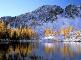
This 24-mile classic loop backpack with 4,200 feet of gain affords immense vistas, beautiful lakes, and glorious larches in the fall! It can be done in three days but endless extensions and side trips beckon.
getting there
From Pateros on the Columbia River, drive 17 miles north on SR-153. Turn left onto Gold Creek Loop Road, drive 1 mile and trun l;eft onto Country Road 1034. Drive 1 mile to a junction and continue straight onto Forest Road 4340. Drive 5.4 and trun left onto Forest Road 4340-300 (signed "Road 300"). Drive 4.6 miles to the a large parking area and the Crater Creek Trailhead (4,700 ft).
From Twisp, drive east 2 miles on SR-20 and the south on SR-153 for 12 miles to Milepost 19. Turn right onto Gold Creek Road, drive 1.5 miles, and turn left onto Country Road 1034 (signed "Foggy Dew Campground"). Drive 1 mile to a junction and continue straight onto Forest Road 4340. Drive 5.4 and trun left onto Forest Road 4340-300 (signed "Road 300"). Drive 4.6 miles to the a large parking area and the Crater Creek Trailhead (4,700 ft).
on the trail
Hike the Crater Creek for ~0.7 mile, turn left onto the Eagle Lake Trail, and take the right fork at 2.2 miles to continue on the Eagle Creek Trail. At 5.8 miles, turn right to hike to upper Eagle Lake (it's 0.5 miles to the lake) or at 7 miles, left to Eagle Lake (it's 0.9 miles to the lake)—neither access trail is well signed. There are established campsites at both lakes, and the upper lake is in a beautiful cirque. A mile beyond the Eagle Lake junction is Horsehead Pass, and the descent to Boiling Lake (8.7 miles from the trailhead). There are several established camp sites and a toilet at the lake.
From Boiling Lake, hike west, following a sign for Cub Lake. In 1.0 mile reach a junction with Cub Lake Trail and Summit Trail, both to the right (west). The Summit Trail provides days of gorgeous wandering on the ridges above Lake Chelan before it descends steeply on the Purple Pass Trail to the lakeshore and Stehekin. From the junction the loop heads south through meadows for 2.0 miles to another fork. Turn left onto the Angels Staircase Trail. This narrow, steep shelf of a trail winds ~0.5 mile to a pass with incredible views. From the pass, continue to traverse the steep bowl for ~0.5 mile until reaching the Merchant Basin Trail junction (may not be marked). Descend northeast and steeply down ~0.6 miles to Cooney lake (snow may make this descent treacherous before July). Campsites and a toilet are at the north end of the lake.
From Cooney Lake, continue ~0.2 miles to a junction with Martin Creek Trail to the right. Turn left (north) onto the Martin Creek Trail and hike for 1.8 miles to Martin Lakes Trail (it's 0.6 mile to Martin Lakes). Continue straight 3.8 miles to the Eagle Lakes Trail, turn right and hike 1.6 mile, then right again and hike 1.5 miles to return to the Crater Lake Trailhead.
Information for Leaders
Scheduling & Permits
- This route allows multiple bookings. Please check scheduled trips listed below in the "Activities" tab to see if there is another group already booked on the same day. Leaders are expected to contact the leader(s) of existing trips to ensure there are no concerns or conflicts, according to The Mountaineers Outdoor Ethics Policy. Please review our Group Size & Multiple Bookings page for guidance.
- Suitable Activities: Backpacking
- Seasons: July, August, September, October
- Weather: View weather forecast
- View avalanche forecast.
- Difficulty: Moderate/Strenuous
- Length: 24.0 mi
- Elevation Gain: 4,200 ft
- 8,100 ft
-
Land Manager:
Okanogan-Wenatchee National Forests
Lake Chelan-Sawtooth Wilderness, Methow Valley Ranger District (OWNF)
- Parking Permit Required: Northwest Forest Pass
- Recommended Party Size: 12
- Maximum Party Size: 12
- Maximum Route/Place Capacity: 12
- Green Trails Prince Creek No. 115
There are no resources for this route/place. Log in and send us updates, images, or resources.
