Trip Report
Stewardship - Three Fingers/South Peak
14hr, 33 mile c2c trip with nighttime gravel biking, glacier viewing, glissading, stemming, meadow sitting, bush-hacking, and berry picking.
- Mon, Sep 6, 2021
- Stewardship - Three Fingers/South Peak
- Three Fingers/South Peak
- Scrambling & Stewardship
- Successful
-

- Road suitable for all vehicles
-
Gear: climbing helmets (also used for biking), poles, trail runners, water filter, ice axe, bike, headlamps and bike lights
Forest road (drivable portion): takes about 40 minutes +/- 20 minutes, depending on your tolerance for potholes. Some potholes, but many are avoidable.
- Bike ride: 8.5 miles & 1400ft one way, going up. Mountain bikes advised, but my gravel bike with 32c tires was ok. Pot holes and ruts are not too much of a problem. Walked bikes a couple times, but an intermediate MTBer could stay in the saddle the entire time. Watch out for 2 cliffy washouts on the left side going up in the first 2 miles (right side going down in the last two miles) -- these have orange flagging. Heading back down was harrowing at night with a gravel road bike, but the folks with mountain bikes enjoyed the ride. Having a headlamp seemed sufficient for night riding, but a bike light is even better.
- Brush: not as bad as advertised, and only thick in the first couple miles. We never lost the trail. Some slippery spots and short stubby root trip hazards.
- Berries: perfect season. The ones past Spade Lake and through Goat Flats were the best.
- Bugs: a couple biters here and there.
- Blowdowns: many in the first couple miles, but all easily navegable.
- Snow: one small snowfield and and a larger glissadable field near the top. The larger snowfield had a couple scattered rocks in the middle, but otherwise the runout was not dangerous. Poles helpful, ice axe and spikes unnecessary for the time of day (3pm) and season.
- Water: Stagnant ponds starting at Spade Lake (2.3 miles in), stream at 3 mi, streams at Goat Flat (4.6+ mi), spring at 7 mi, and snowmelt around the snowfields at the top.
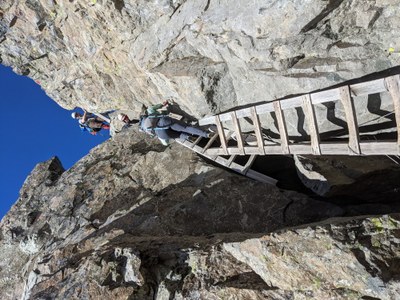
- Dry scrambling: some steep ladders and fun stemming to get up and down from the summit block. One bowling alley with loose rock and a 20+ year old yellow rope.
Hike portion fun details and gpx: https://www.strava.com/activities/5922560986/overview
- 6:30am - met at the junction of NF #41 and Mountain Loop highway in order to caravan by car to end of driveable forest road
- 7:15am - arrive at the washed out bridge where NF #41 crosses South Fork Canyon Creek. Met Don, who had an e-bike and carried the supplies for the lookout maintenance crew up to the trailhead.
- 7:30am - hopped on bikes to ride NF #41 to the Three Fingers (Tin Cap) TH. Navigation very straightforward.
- 9:20am (1hr 50 min bike) - arrived at TH. Locked up bikes in the woods to the right. Picked up the lookout maintenance crew's supplies (food, cleaning supplies, climbing gear) that Don dropped off, and added 10 lb +/- 5lb to our packs.
- 5 hr 20 min hike to the summit of the South Finger, with lunch/snack/water breaks in between.
- 30 min lookout hangout with maintenance crew and 2 other hikers.
- 4 hr 30 min hike down. Beautiful and uneventful.
- 8pm (10 hours of hiking): returned to TH. Unlocked bikes. Set up lights for night riding.
- 9:15pm (1hr 15 min bike) - returned to cars.
 Andrea Lin