
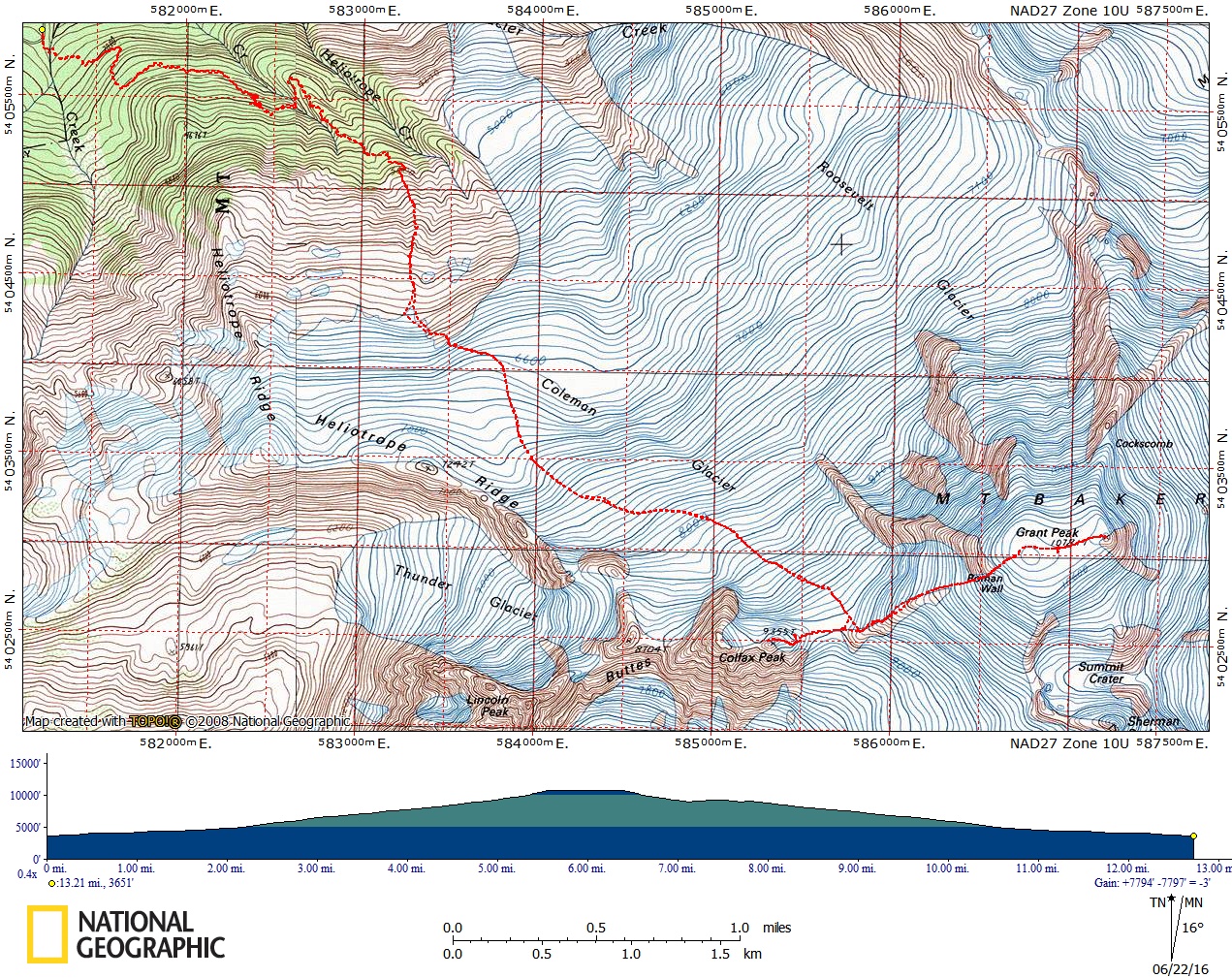
Mount Baker/Coleman Glacier
This route gains 7,000 feet in a distance of 5.5 miles, climbing the moderate Coleman Glacier, the top part of the Deming Glacier, and Roman Wall before reaching the flat summit plateau. Views from camp and the summit are spectacular. Times: 3-4 hr trailhead to camp, 6-9 hr camp to summit.
getting there
From I-5 just north of Bellingham, drive east on SR-542 (Sunset Highway) to 1 mile east of Glacier. Turn right (south) on Forest Road 39 (Glacier Creek Road) and continue 9 miles to head of Mount Baker Trailhead (3,700 ft).
APPROACH
Hike up Heliotrope Ridge Trail to the site of the old cabin and follow climbers' trail beyond (trail is covered with snow early in season) and up steep ridge to moraine at the edge of the glacier. Base camp may be made here (~6,000 ft). Many climbers continue, proceeding south and ascending to ~7,000 ft where base camp can be made along the ridge or at the base of the Black Buttes.
ASCENT ROUTE
Grant Peak (10,778 ft)
Ascend from the base camp, proceed south and climb gradually southeast toward the Black Buttes. Skirt along the Black Buttes, keeping far enough away to avoid avalanches or rockfall, then go easterly to the saddle between the base of the Roman Wall (on the main mountain) and the Black Buttes (~9,200 ft at the saddle). From the saddle, ascend the rocky ridge northeast keeping right of the Roman Wall. Ascend steep snow past the Roman Wall to the large summit plateau. The summit is at the far east-northeast side.
colfax peak (9,355 ft)
From base camp proceed south and climb gradually southeast toward the Black Buttes. Skirt along the Black Buttes, keeping far enough away to avoid avalanches or rockfall, climbing to the saddle between Mount Baker and Colfax Peak. From the saddle climb snow slopes to the summit.
DESCENT ROUTE
Descend the climbing route.
TRIP PROFILE
Grant Peak
| SEGMENT | TIME (HR) | ELEVATION GAIN (FT) |
|---|---|---|
| Trailhead to Camp | 3-4 | 2,300 |
| Camp to Summit | 6-9 | 4,800 |
| Summit to Camp | 2-3 | |
| Camp to Trailhead | 2-3 |
Colfax peak
| SEGMENT | TIME (HR) | ELEVATION GAIN (FT) |
|---|---|---|
| Trailhead to Camp | 3-4 | 2,300 |
| Camp to Summit | 4-6 | 4,400 |
| Summit to Camp | 2-3 | |
| Camp to Trailhead | 2-3 |
EQUIPMENT
Standard glacier equipment including wands.
noteS
- There are many crevasses on this climb.
- The start of the Coleman Glacier can be tricky to discern, so rope up when the slope steepens at ~6,000 ft.
- In good weather views from camp on ridge near Buttes and from summit are spectacular.
- Climb can be done in a single day, if you start very early.
- Forest Road 39 (Glacier Creek road) is susceptible to washouts.
Information for LEADERS
Priority Climbs List
This is a very popular climbing route. Please check the PRIORITY CLIMBS LIST before listing trip to be sure your branch has priority for this route for the dates you plan to schedule it.
Field trips
Use the Heliotrope Ridge and Lower Coleman Glacier & Seracs route/place for glacier travel, crevasse rescue and ice climbing field trips on the lower section of the Coleman Glacier.
- Suitable Activities: Backcountry Skiing, Climbing
- Climbing Category: Basic Alpine
- Seasons: June, July, August
- Weather: View weather forecast
- Difficulty: Technical 3, Strenuous 3, Basic Glacier Climb, M2G Advanced Glacier Ski, Basic Experience Climb
- Length: 11.0 mi
- Elevation Gain: 8,100 ft
- 10,778 ft
-
Land Manager:
Mount Baker-Snoqualmie National Forest
Mount Baker Wilderness, Mount Baker Ranger District (MBSNF)
- Parking Permit Required: Northwest Forest Pass
- Recommended Party Size: 12
- Maximum Party Size: 12
- Maximum Route/Place Capacity: 12
- USGS Mt Baker
- Green Trails Mount Baker Wilderness Climbing No. 13SX
- Green Trails Mt Baker No. 13
This is a list of titles that represent the variations of trips you can take at this route/place. This includes side trips, extensions and peak combinations. Not seeing a title that fits your trip? Log in and send us updates, images, or resources.
- Colfax Peak
| Name/Description |
|---|
| Baker Colfax East Summit Route 6-22-2016 baker+colfax east summit route 6-22-2016 |