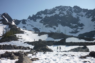
Royal Basin
A strenuous, 14 mile round trip day hike with 2,650 ft in elevation gain and options to climb and scramble. The trail cuts through the Royal Creek vale to a lake beneath snow capped mountains. From the lake head up to Upper Royal Basin and access to scrambles of Mount Deception, Mount Mystery, Mount Fricaba and Hal Foss Peak.
Getting There
From US-101 near Sequim Bay State Park, turn west onto Luella Road and then left onto Palo Alto Road. In 6 miles, turn right onto Forest Road 2880 and then turn left onto Forest Road 2870 in 1.7 miles. In 9 miles, reach the large parking area just past the Dungeness River Bridge (2,500 ft).
on the trail
Royal Lake (5,100 ft) & Upper Royal Basin (5,600 ft)
Hike 7 miles and 2,500 feet of elevation gain to Royal Lake (5,100 ft). It's another mile and 500 feet of elevation gain into the Upper Basin (5,600 ft) where you can explore a network of idyllic meadows, waterfalls, snowfields, and tarns.
scramble routes
Mount Deception (7,788 ft) and Mount Mystery (7,639 ft), Mount Fricaba (7,139 ft) and Hal Foss Peak (7,179 ft) are good scrambling objectives from Upper Royal Basin (5,600 ft). Consider a traverse that includes some or all of them too!
mount deception (7,788 ft)
From Shelter Rock in Royal Basin, climb south then southwest to the small tarn in Upper Royal Basin (camp could be placed here). Climb southwest over a glacial moraine for ~1 mi to the base of a large snow (or mud) slope on the west edge of the northeast face. Climb the steep slope to its head, then directly up to the summit (watch for rock fall!). Time: 5 hr up from Shelter Rock.
Alternative Route: From the flat in Deception Basin, ascend scree and talus northwest and then ascend the left (west) of two gullies just fight of a large rock buttress. Follow the gully system to the east ridge 150 yards southeast of the summit and follow the ridge to the top. Time: 3 hr up from Deception Basin.
The Needles
A series of summits and rock spires on the ridge north of Mount Deception. Depending on the objective, routes range from Class 3 scrambling to 5.8 rock climbing. Spires along The Needles are:
- Martin Peak (7,638 ft)
- The Arrowhead (7,000 ft)
- The Incisor (7,350 ft)
- Mount Johnson (7,650 ft)
- Sweat Spire (7,580 ft)
- Gasp Pinnacle (7,540 ft)
- Devil's Fang (7,600 ft)
- Sundial (7,150 ft)
- Mount Clark (7,528 ft)
- Adelaide Peak (7,300 ft)
- Mount Walkinshaw (7,378 ft)
- Suitable Activities: Backpacking, Day Hiking, Scrambling
- Seasons: June, July, August, September, October
- Weather: View weather forecast
- Difficulty: Strenuous
- Length: 14.0 mi
- Elevation Gain: 2,650 ft
- 5,100 ft
-
Land Manager:
Olympic National Park
Buckhorn Wilderness
- Parking Permit Required: Northwest Forest Pass
- Recommended Party Size: 12
- Maximum Party Size: 12
- Maximum Route/Place Capacity: 12
- Green Trails Olympic Mountains East No. 168S
- Custom Correct Buckhorn Wilderness
- Custom Correct Gray Wolf - Dosewallips
- USGS Mt Deception
This is a list of titles that represent the variations of trips you can take at this route/place. This includes side trips, extensions and peak combinations. Not seeing a title that fits your trip? Log in and send us updates, images, or resources.
- Royal Lake
- Upper Royal Basin
- Royal Lake & Upper Royal Basin
- Mount Fricaba
- Royal Basin & Mount Fricaba
- Hal Foss Peak
- Royal Basin & Hal Foss Peak
- Mount Fricaba & Hal Foss Peak
- Mount Mystery
- Royal Basin & Mount Mystery
- Mystery-Fricaba-Hal Foss Traverse
- Mount Deception
- Royal Basin & Mount Deception
- Mount Fricaba-Mount Deception Traverse
- Fricaba-Deception Traverse
- The Needles
- Martin Peak
- The Arrowhead
- The Incisor
- Mount Johnson
- Sweat Spire
- Gasp Pinnacle
- Devil's Fang
- Sundial
- Mount Clark
- Adelaide Peak
- Mount Walkinshaw
There are no resources for this route/place. Log in and send us updates, images, or resources.
