 Miriel McFarland

Editors note: During the summer of 2016, six current and former Mountaineers Adventure Club (MAC) members hiked the Washington section of the Pacific Crest Trail. This blog is Part 2 of a 4 part recap series. To find out what happened next, read Part 3 b y Stephanie Houston, or to see what happened before with Part 1 by Logan Urrutia. And learn what self proclaimed "gram-weenie" Michael Telstad had in his pack to keep his base weight under 12 lbs through his detailed gear guide.
We stopped at the road near Trout Lake for a food resupply and to briefly say goodbye to Stephanie, who left the trail to see a doctor about her knee.
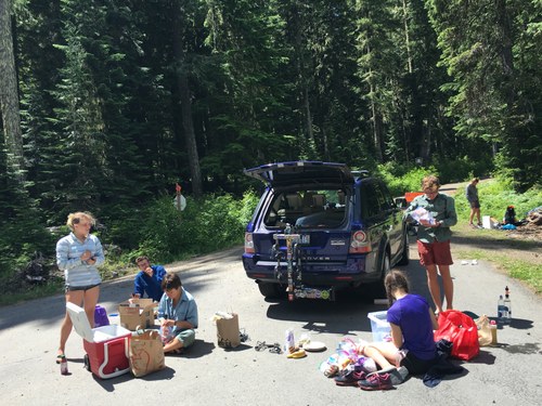 In the warm sun, we laid our damp sleeping bags and clothing to dry out. We filled our bellies with strawberries and cherries, Mochi and salted almonds, and crunchy sugar peas. Across the road I could hear running water and walked over in my old black flip flops to investigate. Sure enough, not far into the trees, there was a stream with a small bridge. I took over my socks and underwear to rinse them (and my dirty feet) in the cool water. As I beat my socks on a boulder, two dark brown weasels scurried and played behind me, running loops around a tree trunk and approaching me curiously.
Back by the road, we began to pack things up—now loaded down by food and the addition of YakTrax for safety on snowfields ahead. A slight wind was picking up and large puffy cumulus clouds began to build and float over the sun. But the sky was still mostly blue and we set out full, happy, and warm.
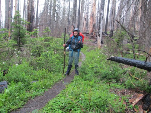
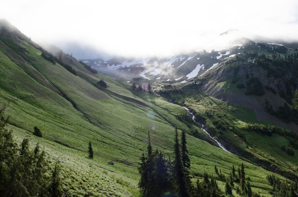
Traveling into the storm
After ascending for awhile, I stopped to filter water where a small waterfall poured out of the hillside. My Camelbak holds 3 liters, and takes some time to fill using my Sawyer bag and filter (which I am proud to report did not crack and lasted the entire trip!). As I was finishing up, Lynnea and Alex caught up to me and decided to filter as well. Just as I put the Camelbak away, the rain hit. We were in the alpine, the trees around us had only trunks and bare branches left over from a previous fire. Lighting and thunder came out of nowhere and the raindrops grew in size. Two trail runners passed us, heading down at almost a sprinting pace. But we were heading into the storm, and being up on this high point, nothing stood between us and the lighting strikes. I put my gaiters and rain coat on and we got moving.
 The rain turned to graupel ice pellets. Small but fierce, the ice pellets ricocheted off the hard packed trail and surrounded me with their constant sound. I pushed my lungs to work harder, planting my walking stick rapidly as I moved faster uphill. The next flat area opened up and I spotted Michael in a rock cave, under one of a few overhanging slabs that offered shelter from the relentless rain. Logan was scouting for more caves, and found some perhaps 100 paces up the trail. I hoped we could sleep there that night, but a small stream of drops leaked in and each cave only had enough space between the gritty soil and ceiling to fit lying down.
OUTRUNNING THE STORM
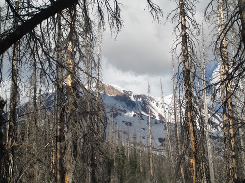
When the rain let up a bit we decided to push on to our planned campsite, a flat grassy field (spongy from the water). I scrambled up the surrounding boulder slope to see if camping on rock would be dryer. Though dryer, camping even a bit higher would increase the danger of being struck by lightning dramatically. We opted instead to just keep moving, approaching Mt. Adams to perhaps outrun the storm. I didn’t believe it was possible, but about 4 miles later, we passed into the sun. With a view of the mountain ahead, we stopped for dinner right on the trail where it had not yet become saturated with water.
 White alpine phlox grew in the cracks between flat rocks and the evening sun shone low all around us. Our destination that night was Riley Creek (11 miles north from back at the road to Trout Lake)-- another meadow campsite but this time much dryer under the clear evening sky. Some hikers had beat us to the spot and taken the sand tent pads, so we pitched our tents and tarps in the grass.
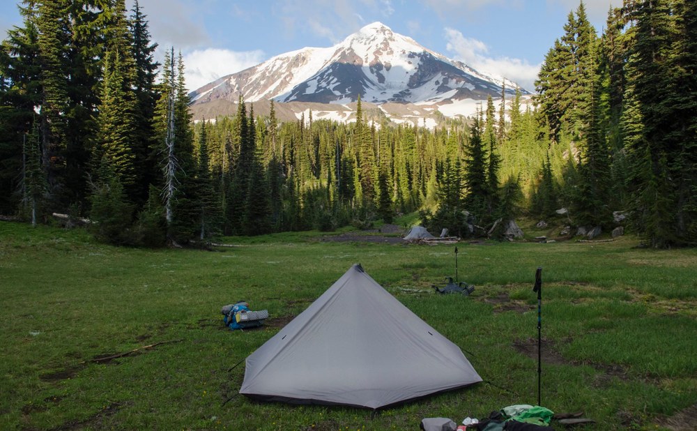
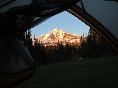
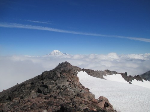
I aligned my tent door facing the mountain, and from my tent, I had this beautiful view of the setting sun’s light on Adams’ glacial surface.
Moving Quickly Through Mt Adams Wilderness
The next day we got up earlier. We planned to get through Goat Rocks in a day, making it from Trout Lake to White Pass in only two and a half days total! For much of the section, we hiked slightly spread apart, waiting at junctions and taking breaks to let anyone catch up who fell behind. I hiked behind Michael and Logan by 10 minutes or so.
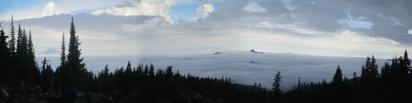
Heading out of the camp site, I passed a few tents of still-sleeping hikers and followed a stream for perhaps a half mile. Crushed red and black lava rock covered the trail in some places along with frequent snowmelt streams from Adams crisscrossing the path. I stopped to take some photos of peaks in the distance, like islands in the sea of clouds below us that stretched as far as I could see.
 When I caught up to Michael and Logan, I saw them on the other side of a raging river, with no clear spot to cross in sight. Michael pointed downstream, indicating a “bridge” of three thin logs. I picked my way over to the branch bridge, took a deep steady breath, and crossed to the other side. Drops of water sprayed the toes of my boots, the left of which was already soaked from a misstep earlier, plunging my boot into a deep puddle. As we waited for Lynnea and Alex and looked over our maps, I ate a delicious juicy apricot that I had saved, along with two plums, from my food resupply at Trout Lake the day before.
Mist soon turned to heavier droplets. We just wanted to get out of the storm, and Michael and I suggested doing all 30 miles that day. Only Michael and I didn’t have a single blister at that point, both Logan and Alex’s feet were in tough shape, and Lynnea was worn out, but they agreed to push on.
I hiked with Michael and Logan, taking a very brisk pace. Speed walking with long strides, as fast as I could go (I’m only 5’5”) without breaking into a jog. The trees were all draped in lichen, so this area probably got rain quite often. The trail itself was becoming a stream and I found myself jumping puddles as I went, one so large I vaulted it using my walking stick. We stopped to wait by a spring and Logan doctored his feet while Michael and I consulted the map. I sometimes wondered, why speed ahead when you’ll just end up waiting for the rest of the group. You might as well go the slowest member’s pace. Besides, why not enjoy every minute of a backpacking trip? Every minute spent in nature should be treasured.
The next wilderness area was Mt. Adams. I crossed the first gravel road I’d seen in awhile, and picked up a permit at the kiosk. Up ahead I could see a dome encrusted in dark green trees: my map read Potato Hill. For a while I led, and found this to be the flattest, straightest section so far. I kept expecting to ascend Potato, but instead the path curved around to the left. Growing tired of my walking stick, I balanced it across the brain of my pack behind my neck. The challenge was not letting the ends of my stick hit small trees that bordered the trail, sending the stick flying and knocking me off balance.
While speeding along, I passed a large, spread out group of backpackers with old gear - exterior frame packs. Soon I crossed into the subalpine as the sun broke through, stopping to talk to a sobo thru hiker whom I consulted about possible storms and snowfields ahead. I finished the last of my mixed nuts (thanks Cristina!) and powered up the hill.
Reaching the top, I following a ridge until I spotted Michael and Logan waiting. Logan was zipped into his mesh bivy, and Michael had his head net on; a cloud of mosquitoes humming around them. I stopped for a few minutes; Michael and Logan were happy to rest for a bit and wait for Lynnea and Alex, but the bugs were quite the annoyance and instead I began to hike downhill, with 9 miles to go until Walupt Creek, our chosen campsite for that night.
I have always loved the alpine; views of mountain peaks, clear skies, tiny plants creeping between the sun lit rocks, but it was time to go back into the dank, dark forest.
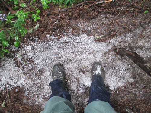 Once back in the cold, dim trees, I felt a crunch under my foot and looked down in surprise. A dip in the trail still held a pile of ice pellets from the storm. As I followed the trail, I checked my map frequently. Our campsite was about 4 miles past the Walupt Lake trail. When I finally reached the sign I was overjoyed, but I still had a good 2 miles uphill coming up. When Michael caught up, I was close to the top of a steep shale section. He told me he had been worried - tracking me, thinking I’d gotten lost. We passed another solo hiker and Michael pulled ahead. When the trail began to descend yet again, I started to get a bit worried. Michael wasn’t in earshot and I thought the rest of the mileage that day would all be uphill. Luckily, I could tell from the topo map lines that Walupt Creek was at the base of a steep slope.
I heard the creek long before reaching it. Crossing a patch of snow and stepping stones in the water, I reached a tiny - and I mean tiny - bank of sand. Another hiker had already taken the tent pad under a tree, and Michael was attempting to stake his tarp tent by the water. The two of us just barely fit, cord stretched out with rocks since the ground wouldn’t take stakes. Just as we lost the last of our light, we climbed into our tents. I cooked a nice hot Mountain House (my one treat night instead of mashed potatoes; rice burrito bowl, my favorite!).
The next day I woke up to the sound of Logan’s alarm music. The fog had remained, settled in the small valley where we slept by the creek, along with the clouds overhead. We heated some water and made instant coffee to share with Lynnea and Alex when they came down to the bank (they had pitched their tents on a flat grassy spot up a short slope above us, where there was more room). As we passed around the coffee, Alex spotted a dim blue spot in the sky. It faded, but that gave us hope for a sunnier day ahead.
Alex took the lead, keeping a consistent relaxed pace as we passed the white diamond PCT blazes. We hiked uphill, passing tiny patches of snow and short true fir trees. When we reached the top of the incline, it was as if we had entered a different land entirely.
 A snowfield stretched out in front of us, behind it jagged black peaks and clouds blowing over. The sun was cooking the fog off! After so much rain the past day and a half, I had never seen something more beautiful.
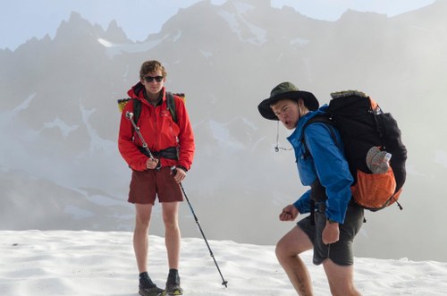
 We traversed bright green hills with sparkling waterfalls cascading down in the distance and watched for mountain goats. We reached a more open area and stopped to take layers off. I snacked on a few brazil and macadamia nuts as we hiked past alpine lilies and marmots perched on flat boulders, nearing Old Snowy Mountain. Up up up, hiking on shale. The summit was so close, so we decided to leave the trail and scramble to the top. Some of the huge boulders required climbing (not as easy with a 35 pound pack on), but we reached the summit quickly. The view was amazing.
 But less than a minute later, wind came out of nowhere over the ridge and clouds surrounded us, dramatically reducing the visibility. We were running out of time and still had over 20 miles to white pass.
As I picked my way down, walking stick in one hand, a loose piece of shale slipped out from underneath my foot and I lost my balance, falling forward onto my left wrist. It snapped backward under me and my pack weight and I lay there for a moment. I thought back to my WFA class and did a mental check. Was my head okay? Luckily, my wrist had caught the fall and not my head. I tested my wrist but it buckled, and after lying there for a moment I stood up shakily and then bent over to pick up my walking stick. Logan asked me if I was alright (I was crying, and that’s not too typical for me) and we walked down together until we met up with the trail again. Logan helped me pin my tank top up in a makeshift sling and put my YakTrax on for me (the snowfields were next!) I had lost every bit of my grip strength - a climber’s worst nightmare - and physically could not button my shirt or tie my shoes.
For a couple of miles we ridge walked and crossed snowfields, some dangerously slanted and bordering sheer cliff drop offs. I slipped once, and was able to arrest with my stick just in time; having only one arm sure screwed up my balance!
We all stayed close together in the snowy section for safety. The Indian Paintbrush here was the most vibrant I have ever seen-- fuchsia instead of orangish red. And although the uphill really got my lungs working, that mile or so was one of my favorite parts of the trail (if you factor out the wrist of course). After going over three more small rolling peaks, we stopped to talk about the plan. White Pass has lodging for hikers, but we were afraid the lodge might close and we had a lot of mileage still to cover. Michael decided to speed ahead and book us a room.
As we descended, the fog started to clear a bit and sun breaks came through. Snow melt streams cut through the flat land. Stones bordered the trail in parts where it was more difficult to find, but boot prints in the snowfields made it easy for us to follow. A steeper rocky spot in the trail led to the widest point of the streams, and I stopped to filter water there.
Filter water with one arm that is, which appeared to actually be impossible. I knew there was no chance I could continue on the next section if I didn’t prove I could be self sufficient, so I took my wrist out of the “sling” delicately and gritted my teeth through filling the bag, and holding the weight of it (2.5 liters) while I screwed the Sawyer on with my good hand. I balanced the opening of the Camelbak between two rocks so I could hold the unfiltered water bag against my body and squeeze with just my right arm. It was almost unbearable, but could be done. I ate a few mini slim jims and a Larabar (quickly-- we wanted to get to White Pass before the Kracker Barrel and Lodge closed) and then hiked on, past the open views of distant hills and peaks and into a more forested area.
I hiked a bit faster, anxious to pull ahead before we hit the next uphill section (the elevation profile showed another 2000 ft of elevation gain ahead) in case I needed to take time to filter again. My wrist began to worsen and I didn’t have enough grip strength to lift my pack off and get some ibuprofen (I feared that lifting anything heavy could shift the bone out of alignment). Luckily, I came across a group of female backpackers who stopped me to ask about the injury. I started telling them the story but began to cry a bit - probably a combination of the pain and overall exhaustion from two 30 mile days. I moved to keep hiking, but one offered me a couple Advil.
Even just hiking our sections as opposed to the whole PCT, we met so many cool people on the trail. I put the pills in my pocket and thanked them, pushing on just as I heard the rest of my group hiking up behind. Not far ahead, I stopped to sit on a log for a minute while they caught up and then we hiked all together at a slower pace for a while.
I saw to my left a barren peak and blue sky through the trees, and that’s when the summit fever hit. I was almost too energetic, a heightened feeling of energy to compensate for the pain, and I knew I needed to get to the top before I wore out entirely. I figured the summit looked about ½ a mile away and told Logan I’d wait for everyone at the top. I raced ahead, taking long strides, almost running uphill, breathing hard. But the summit didn’t seem to get any closer. The trail moved to the right, not to the close peak I had expected it was heading for. Still, I powered uphill, the brief glimpses of false summits offering a burst of excitement.
Longest 2 miles of my life. Still, after deciding to do cross country this year, I can definitively say that backpacking is my favorite exercise. For me, running is training for hiking, so you can be fit enough to relax and enjoy the scenery.
Back in subalpine terrain, the sun burned warm again. A ridge lay ahead past a small boardwalk. I stepped up over the lip and onto a red soil path left of a jagged boulder field. Finally, I sat down on the flattest boulder I could find, resting my pack on the rock to unclip it with my right hand. I took in the view, beautiful despite my pain. Everything was silent. Swallows played and dove down into a valley in front of me. The hills partially in shadow, deep green trees thickly covering the hills, and Old Snowy in the distance to the south! I ate some apple chips and sipped my water, lying back and closing my eyes for a bit to rest and enjoy the heat of the sun. I wanted to be tough, but the pain was too great and I took the advil while looking at my maps, trying to figure out how many miles we had to go. Based on the sign I’d seen for Shoe Lake trail on the way up, we had about 7 miles (downhill!) until White Pass.
My feet were giving out, but the wrist actually seemed to help me in that respect. You don’t really notice blisters or thirst, hunger or bugs, when you have a broken arm. The sun set lower on the horizon as we passed the northern boundary for Goat Rocks. In the distance, I spotted the hut at the top of a chairlift and knew we must be close.
Nope. Not quite. The trail steepened and we hiked on silently until Logan exclaimed that he had received a text from Michael. He called Michael and I listened as Logan hiked behind me. When Logan delivered the news that all the rooms at the lodge were full, I saw Linnea’s face crumple. No bed or shower, carpet or bathroom. I tried to keep things positive: “We’ve barely been out here, surely you don’t miss luxuries that much?... It’ll be good to sleep in tents, they’ll dry out that way!”
I was glad we would be camping out again, not eager to go back to civilization. We made a new plan to get the first room that opened the next morning, and launder our clothes and visit the Kracker Barrel while nursing our feet for a day as we waited for our food resupply to arrive. We could spend the next night in the Lodge before setting out again.
I could feel the skin of my heels peeling off, every step a stab of pain. Stopping was the worst though. You start to move again, and the air becomes Jello. Logan called Stephanie and talked to her for awhile. We were all overjoyed to learn that she would be joining us for the next section. An MRI of her injured knee revealed that hiking would actually do it some good! We took turns talking to her and telling her all about the section. Those 2 ½ days felt like a lifetime of adventures! Talking helped keep us occupied during those last few rough miles and we missed Stephanie’s positive, outgoing attitude. The sunset over the hills through occasional breaks in the dark trees was deep orange.
Soon I could hear highway traffic, but the sound must really carry because we continued to descend for at least 2 miles after that. Alex’s feet were killing him and he started to jog down the trail to get it over with. Why I followed suit (arm bouncing painfully in its sling with each stride) I really don’t know. My nose started to bleed and I gave Alex my walking stick to hold (I couldn’t abandon it now, after 150 miles!) as I held some toilet paper to my nose.
Finally, as it was dark by now, we hit a gravel parking pad at the end of the trail by the highway. A hiker stood by the kiosk there, wearing a long green poncho and camo fisherman’s hat. We stopped to talk to him - he also had been unable to find lodging (there was a cross country camp at the pass, filling up the lodge). Logan and I hiked the last ¾ mile or so, towards the red light by the lodge ahead.
We followed Michael’s directions from his text; up a gravel path to a grassy spot behind the lodges. Michael waved to us - like a long lost friend after such a long day - as he sat in one of a few sturdy wooden chairs circles around his lit campfire pit. I just about fell into one of the chairs and tipped my nose back to slow the bleeding.
Moments later, I spat a long gelatinous blood clot onto the grass, chuckling as Michael turned away in disgust (he’s never had a nosebleed). I struggled to untie my boots to heat my feet on the rocks by the fire, and unclipped my pack, lifting it onto the chair next to me with my good arm. I got some water boiling for mashed potatoes. When it was time to get the hot water, I put my hands on the arms of the chair to lift myself...SNAP.
I fell forward, crying out in pain as my wrist buckled. I took a couple shaky deep breaths and turned the stove off with my right hand, leaned back in the chair, and closed my eyes, clutching my wrist in pain. Michael said softly, “I think it’s broken.” He gave me an ace bandage to wrap around it which I bound tight. I refused to believe it could be broken. I couldn’t leave the trail now! I had to make it to Stehekin, or at least to Stevens!
As it turned out, we couldn’t camp on the pristine, flat grass that night. The woman in charge of the lodge said no more than a single tent could be set up there (preserving the nice green for visiting tourists?). That was the first moment I was truly disheartened. The moon was bright in the night sky, the campfire so warm and cozy. But we had to get up (I didn’t even try to tie my boots back on, staying in my flip flops). We reluctantly grabbed our packs and loose gear, and trudged away into the surrounding trees. As we moved to get going, the hiker with the poncho from the trailhead earlier came striding in. He asked if he could join our campfire and took a seat. At least someone would have a place to stay tonight!
Apparently there was a pond nearby where we were supposed to camp. But after crossing the grass and heading into the trees, headlamps illuminating the tall brown grass, we stepped onto a fairly narrow gravel road. So nice and flat, this was where we had to camp tonight; I didn’t have the strength to move another foot. Michael thought a car or person might come down and find us there, but SO WHAT?! I finally convinced them, and began to set up my tent. With. one. Hand. Have you ever tried assembling an REI quarter dome with one hand? It’s not easy. I used my foot to hold one edge of the tent which bending the poles into the grommets. Everyone else just slept on Logan’s tarp with only sleeping bags, but I didn’t want to risk mine getting wet if another rain shower rolled in. I lay my wrist flat by my head and hoped I wouldn’t roll over in the night, falling asleep to the sound of crickets.
 I was up with the sunrise (yes! No clouds!) before anyone else. Packing up took a while without my left hand (hardest challenge yet: stuffing a sleeping bag) and by the time I was done, my friends were stirring. I let them know before I left that I was going to check out the grounds and followed the gravel path back to the lodge. No one was stirring on the premises; I heard not a single sound but for the automated sprinklers that had just come on to water the grass. I walked down towards the highway and stopped to peek in the window of the Kracker Barrel by the gas station. We would be able to get some breakfast when it opened in a couple hours.
I crossed the highway (almost completely devoid of cars that morning) and strolled over to the base of the small ski area, then headed back across to our fire pit on the grass, spreading my tent and rainfly out over the chairs to dry. When he awoke, we talked to the hiker, who said he had come from Ashland and told us a crazy story about his bear spray exploding in his tent only a day into his trip!
When the Kracker Barrel opened, we went in to eat. I ordered some chai and a poppyseed muffin. After checking out the hiker box, Michael came over to chat. He recommended that I go off trail for the next section to get my wrist looked at. I was crushed but knew he was probably right. If I were to fall again, it could endanger the group, and I was barely able to tie my own boots. I didn’t want to give up, but safety should always come first. An hour or so later, I called my parents and they agreed to pick me up at Lynnea’s house (Lynnea’s parents were bringing the food for the next section at noon).
White pass felt false. The clean lodge room, South Park playing on the TV, shouting kids nearby. When Lynnea’s parents arrived with the food, we had a picnic behind the lodge and looked through our boxes. Mine had fresh plums and strawberries, supposed to be a treat before having only dehydrated potatoes, nuts, and tuna again. But I thought, with a sad tear, I could have all the fruit I wanted now. I said goodbye to everyone and wished them luck before I left to get my wrist X-rayed.
The mountain peaks receded as we drove down the highway, telephone poles replacing trees. At urgent care, I got a fiberglass splint and sling which I wore for the next five days. After that I went back to the doctor, dreading having to get a cast. But, as it turned out, I only needed a brace. “Wait....” It hit me. I could get back on trail!!!
I practically sprinted out of the clinic, and at home packed my backpack again hurriedly. (And there’s a lesson in rushed packing: I forgot the first 3 pages of my maps, and half my first aid supplies). I couldn’t miss the group; they would be at Snoqualmie pass around 12 that afternoon. My mom drove me up and we met Michael’s parents there; they had brought the group’s food. I stepped out of the car, walking stick in hand, eager to breathe in the fresh mountain air again. I have never had a happier time in my life than the days I spent on the PCT! ❤.