
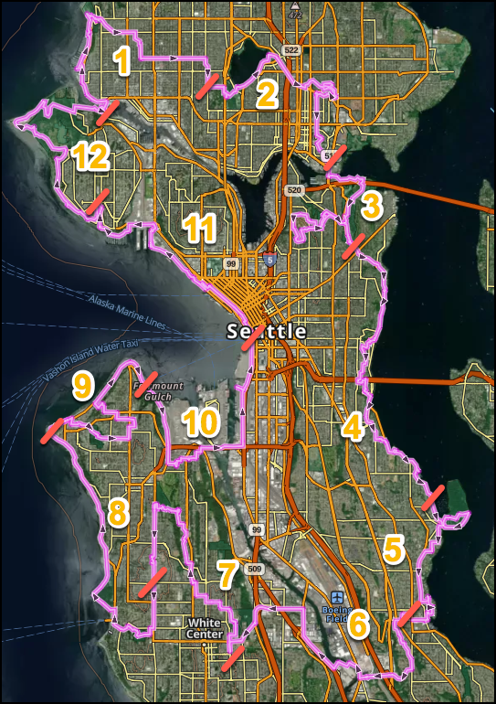
Seattle Olmsted Circuit: Ballard Locks to Rainier Beach to Ballard Locks
The Seattle Olmsted 50 and 70 routes run from the Ballard Locks to the Rainier Beach Playground and onward via West Seattle, Downtown and Discovery Park back to the Locks. The two trails pass through myriad Olmsted Parks and Boulevards. There are twelve 6-mile (10k) sections, each with maps, turn-by-turn directions, and a gpx file. Each of the 12 sections now includes a Loop Option which follow the standard directions until circling back to the start via a novel, shorter route. The 75 mile (120 km) urban trail joins a national network of other large city trails designed for urban walkers.
Maps, turn-by-turn directions and a gpx file are accessed by tapping the Resources folder below.
On the Trail
The Seattle Olmsted 50 route runs 31 miles (50km) from the Ballard Locks to Rainier Beach Playfield, a feast of explorations through the heart of the 1903 Olmsted Park master plan. The Seattle Olmsted 70 route runs 44 miles (70km) from Rainier Beach Playfield through West Seattle, Downtown and Discovery Park back to the Ballard Locks. The route can be done in any north to south order of section(s). Section descriptions run clockwise and include public transportation, public toilets, and treats at both section junctions and midway points. Stroller access is noted.
Seattle olmsted 50
Section 1 starts at the Ballard Locks then goes to Golden Gardens, and finishes at Woodland Park Zoo. It's 5.9 miles one-way with 526 feet of elevation gain (9.4 km with 159 m of elevation gain). Loop Option to Golden Gardens and return is 8.7 km (5.4 mi), 133 m (439 ft) elevation gain.
Section 2 starts at Woodland Park Zoo and then goes to Green Lake, Cowen/Ravenna Parks, Ravenna Boulevard, and finishes near Husky Stadium. It's 6.4 miles one-way with 362 feet of elevation gain (10.3 km with 110 m of elevation gain). Loop Finish Option to Green Lake and return is 7.9km (4.9 mi), 109 m (360 ft) elevation gain.
Section 3 starts near Husky Stadium then goes to Marsh & Foster Islands, The Arboretum, Interlaken Park, Volunteer and Louisa Boren Parks, and finishes at Washington Park Playfield. It's 6.7 miles one-way with 650 feet of elevation gain (10.7 km with 197 m of elevation gain). Another 75 feet of elevation gain gets you to the views atop the Volunteer Park Water Tower. Loop Finish Option to lower Interlaken Park and return is 6.6 km (4.1 mi), 130 m (429 ft) elevation gain.
Section 4 starts at the Washington Park Playfield then goes to Lake Washington Boulevard, Denny Blaine, Viretta, Howell, Madrona, Leschi, Frink, Colman and Mount Baker Parks, and Hunter Boulevard, and finishes at Stan Sayres and Genesee Parks. It's 6 miles one-way with 585 feet of elevation gain (9.7 km with 177 m of elevation gain). Loop Finish Option to Madrona and return is 7 km (4.7 mi), 171 m (564 ft) elevation gain.
Section 5 starts at Stan Sayres Memorial Park and Boat Launch then goes to Lake Washington Boulevard, Seward Park, Martha Washington Park, Pritchard Island Beach, Rainier Beach Urban Farm, Be'er Shiva Park, and finishes at Rainier Beach Playfield . It's 6.8 miles one-way with 445 feet of elevation gain (10.8 km with 139 m of elevation gain). Loop Finish Option to Seward Park and return is 6.6 km (4.1 mi), 136 m (449 ft) elevation gain.
Seattle olmsted 70
Section 6 starts at Rainier Beach Community Center (beside the Playfield) then follows the Chief Sealth Trail before crossing over I-5 and the Duwamish River towards South Park. The trail continues under Hwy99 then over SR509 by bus or on foot to White Center and Dubsea Coffee in Greenbridge. Much of the route follows the path of the Olmsted’s unrealized Dunlap Canyon Parkway. It’s 7.3 miles one-way with 767 feet elevation gain (11.7km, 234 m of elevation gain). Loop Finish Option to MLK Jr intersection and return 6.1 km (3.8 mi), 94 m (310 ft) elevation gain.
Section 7 starts in the Greenbridge Neighborhood through Westcrest and Highland Parks before moving through the Longfellow Creek Natural Area to Greg Davis Park. Elevation is regained to and through Camp Long, site of the CCC built Schurman Rock where legendary Mountaineers trained. The route finishes south down 35th Avenue SW along the unrealized South Bourne Parkway to Myrtle Reservoir Park and Seattle’s High Point, elevation 520ft. It’s 6 miles one-way with 529 feet elevation gain (9.6 km, 162 m of elevation gain). Loop Finish Option to Delridge Way and return 7.2 km (4.4 mi), 66 m (317 ft) elevation gain.
Section 8 starts at High Point between the two standpipes and heads through Fauntleroy Park past Captain’s Park and the Fauntleroy Ferry Terminal to Lincoln Park. The Bruun Idun Troll greets shoreline walkers on their way to Lowman Beach Park. Passing Me-Kwa-Mooks Park near the unrealized Sound Bluffs Parkway, the route pauses in Constellation Park to end at the Coast Guard Alki Point Lighthouse. . It’s 6.9 miles one-way with 143 feet elevation gain (11.1 km, 44 m of elevation gain). Loop Finish Option to Lincoln Park and return 8.3 km (r.1 mi), 250 m (825 ft) elevation gain.
Section 9 starts at Alki Point and passes along Alki Beach Park and Alki Playground before entering Schmitz Boulevard and Schmitz Preserve Park where old growth trees are yet found. Crossing over the unrealized West Seattle Parkway, the route leads to Hiawatha Playfield, an Olmsted city park. The route finishes down sets of little known stairs to walk along the beach via the intended Duwamish Head Parkway at the Seacrest Park Foot Ferry Terminal. It’s 5.3 miles one-way with 425 feet elevation gain (8.6 km, 130 m of elevation gain). Loop Finish Option to Schimitz Preserve Park and return 7.1 km (4.4 mi), 134 m (442 ft) elevation gain.
Section 10 starts at the Seacrest Foot Ferry Terminal and heads south, on the Alki Trail past Jack Block Park to the Dragonfly Pavilion and Gardens and Salmon Bone Bridge in the Longfellow Creek Greenspace. The trail climbs stairs and sidewalks to Pigeon Point in the West Duwamish Green Belt then down to pass over the Duwamish River on the Spokane Street Bridge. This maritime industry walk finishes near the Pioneer Square Habitat Beach and Seattle Foot Ferry Terminal. It’s 5.9 miles one-way with 340 feet elevation gain (9.5 km, 104 m of elevation gain). Loop Finish Option to Longfellow Creek and return 8 km (5 miles), 184 m (607 ft) elevation gain.
Section 11 starts at the Seattle Ferry Terminal and celebrates public art installations through downtown past Hammering Man to the Pike Place Market and the Olympic Sculpture Garden. Myrtle Edwards Park leads past more sculptures to the Terminal 86 Grain Facility, then passes over the Magnolia Bridge to the Elliott Bay Marina below the Admiral’s House high on the bluff. A concealed path leads to Hidden Beach street end and then to the Magnolia Village Pub. It’s 6 miles one-way with 352 feet elevation gain (9.6 km, 107m of elevation gain). Loop Finish Option to Myrtle Edwards Park and return 5.5 km (3.4 mi), 126 m (416 ft) elevation gain.
Section 12 starts in Magnolia Village and runs along the Magnolia Boulevard W where great views lead to a long stairway down to Perkins Lane (where houses have slid into the Sound). The trail rises to Discovery Park to again follow the bluff until finding the West Point Lighthouse. A switch backed trail leads back into the heart of Fort Lawton passing Daybreak Star on the way to Commodore Park and the Ballard Locks, to complete the 120km circuit. It’s 6.7 miles one-way with 779 feet elevation gain (10.8 km, 237m of elevation gain). Loop Finish Option to Perkins Lane and return 7.6 km (4.7 mi), 234 m (772ft) elevation gain.
Notes
- Walkers are on the traditional land of the Coast Salish peoples who live here and steward these lands and waters as they have for time immemorial.
- The Seattle Olmsted Circuit 50/-70 is a joint project of The Mountaineers Seattle Urban Walk Committee and Friends of Seattle's Olmsted Parks.
Information for Leaders
Scheduling
- This route allows multiple bookings. Please check scheduled trips listed below in the "Activities" tab to see if there is another group already booked on the same day. Leaders are expected to contact the leader(s) of existing trips to ensure there are no concerns or conflicts, according to The Mountaineers Outdoor Ethics Policy. Please review our Group Size & Multiple Bookings page for guidance.
- Suitable Activities: Urban Walking
- Seasons: Year-round
- Weather: View weather forecast
- Difficulty: Easy/Moderate
- Length: 75.0 mi
- Elevation Gain: 5,853 ft
- 520 ft
- Land Manager: Seattle Parks and Recreation
- Parking Permit Required: None
- Recommended Party Size: 12
- Maximum Party Size: 25
- Maximum Route/Place Capacity: 25
This is a list of titles that represent the variations of trips you can take at this route/place. This includes side trips, extensions and peak combinations. Not seeing a title that fits your trip? Log in and send us updates, images, or resources.
- Seattle Olmsted 50
- Seattle Olmsted 50: Section 1
- Seattle Olmsted 50: Section 1, Loop
- Ballard Locks to Woodland Park Zoo
- Seattle Olmsted 50: Ballard Locks to Woodland Park Zoo
- Seattle Olmsted 50: Section 2
- Seattle Olmsted 50: Section 2, Loop
- Woodland Park Zoo to Husky Stadium
- Seattle Olmsted: Woodland Park Zoo to Husky Stadium
- Seattle Olmsted 50: Section 3
- Seattle Olmsted 50: Section 3, Loop
- Husky Stadium to Washington Park Playfield
- Seattle Olmsted 50: Husky Stadium to Washington Park Playfield
- Seattle Olmsted 50: Section 4
- Seattle Olmsted 50: Section 4, Loop
- Washington Park Playfield to Stan Sayres and Genessee Parks
- Seattle Olmsted 50: Washington Park Playfield to Stan Sayres and Genessee Parks
- Seattle Olmsted 50: Section 5
- Seattle Olmsted 50: Section 5, Loop
- Stan Sayres Memorail Park to Rainier Beach Playfield
- Seattle Olmsted 50: Stan Sayres Memorail Park to Rainier Beach Playfield
- Seattle Olmsted 70: Section 6
- Seattle Olmsted 70: Section 6, Loop
- Rainier Beach Community Center to White Center
- Seattle Olmsted 70: Rainier Beach Community Center to White Center
- Sections 6 & 7 Rainier Beach Community Center to Greg Davis Park
- Seattle Olmsted 70: Section 7
- Seattle Olmsted 70: Section 7, Loop
- Greenbridge Neighborhood to Greg Davis Park
- Seattle Olmsted 70: Greenbridge Neighborhood to Greg Davis Park
- Seattle Olmsted 70: Section 8
- Seattle Olmsted 70: Section 8, Loop
- High Point to Lincoln Park
- Seattle Olmsted 70: High Point to Lincoln Park
- Sections 8 & 9 High Point to Seacrest Park Ferry Terminal
- Seattle Olmsted 70: Section 9
- Seattle Olmsted 70: Section 9, Loop
- Alki Point to Seacrest Park Foot Ferry Terminal
- Seattle Olmsted 70: Alki Point to Seacrest Park Foot Ferry Terminal
- Seattle Olmsted 70: Section 10
- Seattle Olmsted 70: Section 10, Loop
- Seacrest Foot Ferry Terminal to the Pioneer Square Habitat Beach and Seattle Foot Ferry Terminal
- Seattle Olmsted 70: Seacrest Foot Ferry Terminal to the Pioneer Square Habitat Beach and Seattle Foot Ferry Terminal
- Sections 10 & 11 Seacrest Foot Ferry Terminal to the Magnolia Village Pub
- Seattle Olmsted 70: Section 11
- Seattle Olmsted 70: Section 11, Loop
- Seattle Ferry Terminal to the Magnolia Village Pub
- Seattle Olmsted 70: Seattle Ferry Terminal to the Magnolia Village Pub
- Seattle Olmsted 70: Section 12
- Seattle Olmsted 70: Section 12, Loop
- Magnolia Village to Ballard Locks
- Seattle Olmsted 70: Magnolia Village to Ballard Locks
| Name/Description |
|---|
| Seattle Olmsted 50 Map A map of the Seattle Olmsted 50 route done in GAIA GPS by Peter Hendrickson Oct 2023. |
| Seattle Olmsted 50 GPX File A GPX file of the Seattle Olmsted 50 route by Peter Hendrickson Oct 2023. |
| Seattle Olmsted 120 Entire Circuit Map Image A map of the entire Seattle Olmsted 120 circuit with segment junction markings. |
| Seattle Olmsted 120 Entire Circuit GPX File A GPX file for the entire Seattle Olmsted 120k circuit |
| Information for Leaders |
| Seattle Olmsted 50 Section 1 Resources Starts at the Ballard Locks then goes to Golden Gardens, and finishes at Woodland Park Zoo. It's 5.9 miles one-way with 526 feet of elevation gain (9.4 km with 159 m of elevation gain). Loop Option to Golden Gardens and return is 8.7 km (5.4 mi), 133 m (439 ft) elevation gain. |
| Seattle Olmsted 50 Section 2 Resources Starts at Woodinville Park Zoo and then goes to Green Lake, Cowen/Ravenna Parks, Ravenna Boulevard, and finishes near Husky Stadium. It's 6.4 miles one-way with 362 feet of elevation gain (10.3 km with 110 m of elevation gain). Loop Finish Option to Green Lake and return is 7.9km (4.9 mi), 109 m (360 ft) elevation gain. |
| Seattle Olmsted 50 Section 3 Resources Starts near Husky Stadium then goes to Marsh & Foster Islands, The Arboretum, Interlaken Park, Volunteer and Louisa Borken Parks, and finishes at Washington Park Playfield. It's 6.7 miles one-way with 650 feet of elevation gain (10.7 km with 197 m of elevation gain). Another 75 feet of elevation gain gets you to the views atop the Volunteer Park Water Tower. Loop Finish Option to lower Interlaken Park and return is 6.6 km (4.1 mi), 130 m (429 ft) elevation gain. |
| Seattle Olmsted 50 Section 4 Resources Starts at the Washington Park Playfield then goes to Lake Washington Boulevard, Denny Blaine, Viretta, Howell, Madrona, Leschi, Frink, Colman and Mount Baker Parks, and Hunter Boulevard, and finishes at Stan Sayres and Genesee Parks. It's 6 miles one-way with 585 feet of elevation gain (9.7 km with 177 m of elevation gain). Loop Finish Option to Madrona and return is 7 km (4.7 mi), 171 m (564 ft) elevation gain. |
| Seattle Olmsted 50 Section 5 Resources Starts at Stan Sayres Memorial Park and Boat Launch then goes to Lake Washington Boulevard, Seward Park, Martha Washington Park, Pritchard Island Beach, Rainier Beach Urban Farm, Be'er Shiva Park, and finishes at Rainier Beach Playfield . It's 6.8 miles one-way with 445 feet of elevation gain (10.8 km with 139 m of elevation gain). Loop Finish Option to Seward Park and return is 6.6 km (4.1 mi), 136 m (449 ft) elevation gain. |
| Seattle Olmsted 70 Section 6 Resources Starts at Rainier Beach Community Center (beside the Playfield) then follows the Chief Sealth Trail before crossing over I-5 and the Duwamish River towards South Park. The trail continues under Hwy99 then over SR509 by bus or on foot to White Center and Dubsea Coffee in Greenbridge. Much of the route follows the path of the Olmsted’s unrealized Dunlap Canyon Parkway. It’s 7.3 miles one-way with 767 feet elevation gain (11.7km, 234 m of elevation gain). Loop Finish Option to MLK Jr intersection and return 6.1 km (3.8 mi), 94 m (310 ft) elevation gain. |
| Seattle Olmsted 70 Section 7 Resources Starts in the Greenbridge Neighborhood through Westcrest and Highland Parks before moving through the Longfellow Creek Natural Area to Greg Davis Park. Elevation is regained to and through Camp Long, site of the CCC built Schurman Rock where legendary Mountaineers trained. The route finishes south down 35th Avenue SW along the unrealized South Bourne Parkway to Myrtle Reservoir Park and Seattle’s High Point, elevation 520ft. It’s 6 miles one-way with 529 feet elevation gain (9.6 km, 162 m of elevation gain). Loop Finish Option to Delridge Way and return 7.2 km (4.4 mi), 66 m (317 ft) elevation gain. |
| Seattle Olmsted 70 Section 8 Resources Starts at High Point between the two standpipes and heads through Fauntleroy Park past Captain’s Park and the Fauntleroy Ferry Terminal to Lincoln Park. The Bruun Idun Troll greets shoreline walkers on their way to Lowman Beach Park. Passing Me-Kwa-Mooks Park near the unrealized Sound Bluffs Parkway, the route pauses in Constellation Park to end at the Coast Guard Alki Point Lighthouse. It’s 6.9 miles one-way with 143 feet elevation gain (11.1 km, 44 m of elevation gain). Loop Finish Option to Lincoln Park and return 8.3 km (r.1 mi), 250 m (825 ft) elevation gain. |
| Seattle Olmsted 70 Section 9 Resources Starts at Alki Point and passes along Alki Beach Park and Alki Playground before entering Schmitz Boulevard and Schmitz Preserve Park where old growth trees are yet found. Crossing over the unrealized West Seattle Parkway, the route leads to Hiawatha Playfield, an Olmsted city park. The route finishes down sets of little known stairs to walk along the beach via the intended Duwamish Head Parkway at the Seacrest Park Foot Ferry Terminal. It’s 5.3 miles one-way with 425 feet elevation gain (8.6 km, 130 m of elevation gain). Loop Finish Option to Schimitz Preserve Park and return 7.1 km (4.4 mi), 134 m (442 ft) elevation gain. |
| Seattle Olmsted 70 Section 10 Resources Starts at the Seacrest Foot Ferry Terminal and heads south, on the Alki Trail past Jack Block Park to the Dragonfly Pavilion and Gardens and Salmon Bone Bridge in the Longfellow Creek Greenspace. The trail climbs stairs and sidewalks to Pigeon Point in the West Duwamish Green Belt then down to pass over the Duwamish River on the Spokane Street Bridge. This maritime industry walk finishes near the Pioneer Square Habitat Beach and Seattle Foot Ferry Terminal. It’s 5.9 miles one-way with 340 feet elevation gain (9.5 km, 104 m of elevation gain). Loop Finish Option to Longfellow Creek and return 8 km (5 miles), 184 m (607 ft) elevation gain. |
| Seattle Olmsted 70 Section 11 Resources Starts at the Seattle Ferry Terminal and celebrates public art installations through downtown past Hammering Man to the Pike Place Market and the Olympic Sculpture Garden. Myrtle Edwards Park leads past more sculptures to the Terminal 86 Grain Facility, then passes over the Magnolia Bridge to the Elliott Bay Marina below the Admiral’s House high on the bluff. A concealed path leads to Hidden Beach street end and then to the Magnolia Village Pub. It’s 6 miles one-way with 352 feet elevation gain (9.6 km, 107m of elevation gain). Loop Finish Option to Myrtle Edwards Park and return 5.5 km (3.4 mi), 126 m (416 ft) elevation gain. |
| Seattle Olmsted 70 Section 12 Resources Starts in Magnolia Village and runs along the Magnolia Boulevard W where great views lead to a long stairway down to Perkins Lane (where houses have slid into the Sound). The trail rises to Discovery Park to again follow the bluff until finding the West Point Lighthouse. A switch backed trail leads back into the heart of Fort Lawton passing Daybreak Star on the way to Commodore Park and the Ballard Locks, to complete the 120km circuit. It’s 6.7 miles one-way with 779 feet elevation gain (10.8 km, 237m of elevation gain). Loop Finish Option to Perkins Lane and return 7.6 km (4.7 mi), 234 m (772ft) elevation gain. |