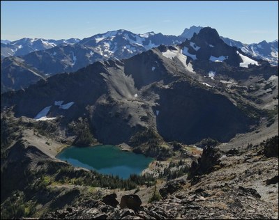
Petunia Peaks
A moderately challenging scramble with a great approach along the divide between Dungeness River and Royal Creek. With grand views of Royal Basin, The Needles, Mount Deception, Mount Mystery, and many more. It's 14 miles with an estimated cumulative elevation gain of over 5,000 vertical feet.
getting there
From US 101 near Sequim Bay State Park, turn west onto Luella Road and then left onto Palo Alto Road. In 6 miles, turn right onto Forest Road 2880 and then turn left onto Forest Road 2870 in 1.7 miles. In 9 miles, reach the large parking area just past the Dungeness River Bridge (2,500 ft).
approach & ascent
Hike the Upper Dungeness Trail (#833) for about a mile and continue over the bridge that crosses Royal Creek. Just after crossing the bridge leave the trail and gain Petunia Peak's north ridge. Continue on the ridge as you go up and over a few bumps along the way to Petunia Peak. Summit North Petunia Peak North (6,698 ft) and then Petunia Peak (6,953 ft) on its northwest side with easy rock and talus scrambling.
An alternative route (ascent or descent) is to continue on Upper Dungeness Trail to Camp Hardy. Leave the trail, cross the river on a log, and make your way up the very steep path to Goat Lake (5,992 ft). From there join the main route on the north ridge.
Notes
- These peaks are not named on maps. The lower of the two peaks is called Petunia Peak (6,953 ft) and he higher is called North Petunia Peak (6,996 ft).
- It's possible to ascend from the west via Royal Basin, but it's a longer trip on a somewhat more popular trail.
- Suitable Activities: Scrambling
- Seasons: May, June, July, August, September, October
- Weather: View weather forecast
- Difficulty: Strenuous 4, Technical 3
- Length: 14.0 mi
- Elevation Gain: 5,500 ft
- 6,998 ft
-
Land Manager:
Olympic National Forest
Buckhorn Wilderness, Hood Canal Ranger District (ONF)
- Parking Permit Required: Northwest Forest Pass
- Recommended Party Size: 12
- Maximum Party Size: 12
- Maximum Route/Place Capacity: 12
- USGS Mt Deception
- Green Trails Tyler Peak No. 136
- Green Trails Olympic Mountains East No. 168S
- Custom Correct Buckhorn Wilderness
This is a list of titles that represent the variations of trips you can take at this route/place. This includes side trips, extensions and peak combinations. Not seeing a title that fits your trip? Log in and send us updates, images, or resources.
- Petunia Peak
- North Petunia Peak
- Petunia Peak & North Petunia Peak
There are no resources for this route/place. Log in and send us updates, images, or resources.
