Bear Creek Mountain
A short, 7-mile hike in the Goat Rocks Wilderness to a summit with great views. With 1,000 feet of elevation gain in the last mile, it's also a challenging hike.
getting there
Drive US-12 to 26.9 miles east of Packwood/42 miles west of Yakima and turn south onto Clear Lake/Tieton Road (Forest Road 1200). Drive 3 miles, around the west end of Clear Lake, and turn left to continue on Forest Road 1200. Drive 2 miles and bear right and uphill at a "Y" intersection onto Forest Road 1205. Drive 4.8 miles, turn left onto Road 742, drive 0.2 mile, and turn right onto Forest Road 1204. Drive 3.7 miles to the road's end and the Section 3 Lake campground and trailhead (6,100 ft).
The last two miles of Forest Road 1204 are very rough. High clearance vehicles are recommended.
On the Trail
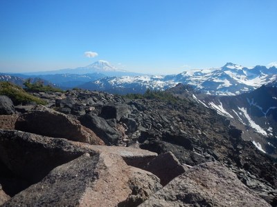
Hike the Bear Creek Mountain Trail passing a junction with the Tieton Meadows Trail in 0.9 mile. Continue 1.8 miles to the junction with the tail to the Bear Creek Lookout. This last 0.9 mile to the Bear Creek Mountain summit is steep with a 1,000 feet of elevation gain. Enjoy the views including Mount Rainier, Mount Adams, and the peaks in the Goat Rock Wilderness.
- Suitable Activities: Day Hiking
- Seasons: July, August, September, October
- Weather: View weather forecast
- Difficulty: Moderate
- Length: 7.0 mi
- Elevation Gain: 1,237 ft
- 7,337 ft
-
Land Manager:
Okanogan-Wenatchee National Forests
Goat Rocks Wilderness, Naches Ranger District (OWNF)
- Parking Permit Required: None
- Recommended Party Size: 12
- Maximum Party Size: 12
- Maximum Route/Place Capacity: 12
- Green Trails Goat Rocks William O Douglas Wilderness No. 303S
- Green Trails White Pass No. 303
There are no resources for this route/place. Log in and send us updates, images, or resources.
