Trip
Backpack - Seven Lakes Basin & High Divide
A leisurely four days in the Olympic high country.
- Wed, Aug 24, 2016 — Sat, Aug 27, 2016
- Seattle Backpacking Committee
- Backpacking
- Adults
- Moderate/Strenuous
- Moderate
- Mileage: 22.3 mi
- Elevation Gain: 7,100 ft
- FULL, 2 on waitlist (5 capacity)
- Cancellation & Refund Policy
Sol Duc Trailhead trailhead at 10:00am. Map: https://goo.gl/maps/VuYUDUHzLgN2
Carpools will likely be set up. (Because of the duration of the trip, leaving cars at a Park and Ride is not an option.)
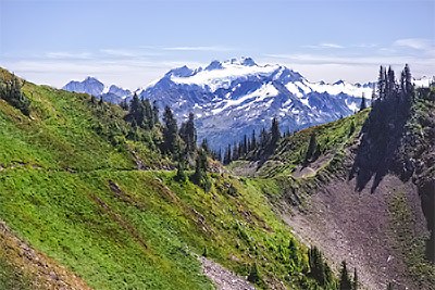
Regarded as one of the better multi-night routes in the Olympics, the High Divide Loop is usually done in three strenuous days. This trip is stretches the trip out into a more leisurely four days, and tacks on a day short day trip along the Cat Basin Primitive trail (an unofficial extension of the High Divide Trail). Daily mileages are short (except for the final hike out) so that we can spend more time taking in the views, exploring the area, and simply hanging out in the Olympic high country. In the mornings our goal will be to get on the trail by 9am (which some would consider downright slovenly) so that we can take in the morning sights as well.
Though mileage numbers are modest, daily elevation gains/losses are not. This trip still requires that participants be in good condition.
Itinerary:
The Trip Leader has a permit for the following campsites:
- Wednesday 8/24 - Sol Duc Crossing/Upper Sol Duc Bridge
- Thursday 8/25 - Heart Lake
- Friday 8/26 - Lunch Lake (a.k.a. Seven Lakes Basin)
Day One (5.4 miles, 2000 ft gain, 600 ft loss): Hike along the Sol Duc River, doing our low-country leg on the first day when our packs are heaviest.
Day Two (5.6 miles, 2700' gain, 1200' loss): A short 2.5-mile hike to Heart Lake, where we will set up camp relatively early in the day then take an out-and-back day hike along the Cat Basin Primitive Trail, an extension of the High Divide Trail that extends east of Heart Lake Camp. The daily mileage/elevation estimate is based on turning around when we reach the fork with the Bailey Range Way Trail, though our actual turnaround point will be decided by the group.
Day Three (3.8 miles, 1500' gain, 1700' loss): Hike along the High Divide Trail to Lunch Lake in Seven Lakes Basin. Along the way we may decide as a group to also take the side trail to the summit of Bagachiel Peak. The plan again is to set up camp relatively early in the day then explore the area.
Day Four (7.5 miles, 950' gain, 3500' loss): Hike another another 3.6 miles along the High Divide Trail before turning north at Deer Lake and descending back to the trailhead.
Special Considerations:
- This trip is in bear country. Bear canisters are required (Park Service rules)
- Participants are requested to reimburse the Trip Leader $15 each for their share of the cost of the Wilderness Permit ($5 per night per person). Doing so during the trip itself is fine.
- We'll be in the Olympics, so it is unlikely that we will get four consecutive days without any rain at all. Please expect that we will get rained on during part of the trip. If we don't then great, but we shouldn't be surprised if it happens.
Leaders Permission:
Regarding "Leader's Permission Required": This is not a trip for inexperienced backpackers. If your online Activity History does not include any backpacking trips please provide the trip leader with a brief summary of your recent backpacking experience.
Seven Lakes Basin & High Divide
-
Green Trails Seven Lakes Basin/Mt Olympus Climb No. 133S
Custom Correct Seven Lakes Basin - Hoh
USGS Mount Carrie
USGS Bogachiel Peak - See full route/place details.
Required Equipment
- Your usual multi-night kit.
- Bear canister.
