Field trip: Conditioning Hiking Series
CHS 2 Hike - Kachess Ridge
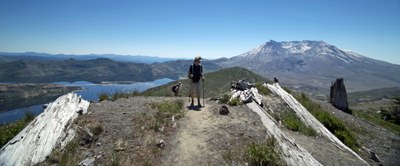
A delightful ridge hike through open meadows with a side trip up to Kachess Beacon. Great views of the surrounding peaks and lakes. CHS 2 pace (2.0-3.0 mph)
- Sat, Jun 19, 2021
- Seattle Hiking Committee
- Day Hiking
- Adults
- Strenuous
- Challenging
- Mileage: 7.2 mi
- Elevation Gain: 1,474 ft
- High Point Elevation: 4,600 ft
- Pace: 2.0-3.0 mph
- 2 (7 capacity)
- Cancellation & Refund Policy
Meet at 7:45 AM at the trailhead.
From Seattle, drive east on I-90 to exit 70, signed for Lake Easton State Park. At the end of the ramp, turn left over the freeway. At the ‘T’, go left on Kachess Dam Road for one half mile, then right to stay on Kachess Dam Road (FR 4818). Travel another 0.8 mile, mostly on gravel, then turn right onto an unmarked one-lane dirt road. The road is rutted but passable by most vehicles. At 0.6 mile, the dirt road ends at the trailhead. There is parking for about 10 vehicles, including along the shoulder.
Northwest Forest pass is not required.
We'll hike along the Silver Creek trail and up to the Beacon, then wander along the ridge for two more miles. Total length about 1o miles. Optional - we can add another mile each way to reach 12 miles if desired.
There will probably be some patches of snow but nothing serious. Micro-spikes are optional.
As always dress for any unexpected change in the weather, such as rain, snow cold, wind etc.
Kachess–Domerie Loop
-
Green Trails Alpine Lakes East (Stuart Range) No. 208SX
Green Trails Kachess Lake No. 208
USGS Kachess Lake - See full route/place details.
Required Equipment
Ten Essential Systems
- Navigation (map & compass)
- Sun protection (sunglasses & sunscreen)
- Insulation (extra clothing)
- Illumination (headlamp/flashlight)
- First-aid supplies
- Fire (waterproof matches/lighter/candle)
- Repair kit and tools
- Nutrition (extra food)
- Hydration (extra water)
- Emergency shelter (tent/plastic tube tent/garbage bag)
