Field trip: Conditioning Hiking Series
CHS 1 Hike - Kachess–Domerie Loop
CHS1 hike led at a pace of 1.5-2.0 mph. This is an out-and-back hike heading north on Kachess Ridge then east towards South Peak.
- Sun, Aug 4, 2019
- Seattle Hiking Committee
- Day Hiking
- Adults
- Strenuous/Very Strenuous
- Moderate
- Mileage: 14.0 mi
- Elevation Gain: 3,500 ft
- High Point Elevation: 5,400 ft
- Pace: 1.5-2.0 mph
- 12 (11 capacity)
- Cancellation & Refund Policy
Probably 6:30 AM at Issaquah Transit Center;I'll send details to people who are registered for the hike. I can take up to 3 others from the Greenlake Park and Ride in Seattle to the Issaquah meeting place.
NOT a loop: M'eers requires choosing an existing title and route description from their database and that was the closest--but at least the driving instructions to the trailhead are accurate. The plan: 5 miles and 2300 feet gain north on the Kachess Ridge (Silver Creek) trail # 1315. The first 1.5 miles are very, very steep (but mostly good footing); then level or gently uphill along the creek before moderate 700-foot climb to the 5 mile mark at the intersection with Silver Creek Tie # 1308.1. East on that to where it intercepts the Domerie Peak trail at the base of South Peak. This cross-over trail is nominally 2.1 miles (probably a bit more) and additional 700 feet net gain. But it has significant ups and downs , so a guess of 3500 feet cumulative gain for the whole hike is reasonable. In fact, it might be more if you add loss and gain on the return over this section. If Aug 4 turns out to be very hot we can cut the hike somewhat shorter, but ideally I'd like to get to the intersection with Domerie Peak trail.
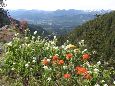
The trail along Silver Creek is lovely, and we get into flower meadows a bit before the 5 mile mark. Parts of the crossover trail will have views south to Mt.Rainier, north to the Stuart Range, and east to Cle Elum Lake. The Kachess Ridge Trail has a few shallow but wide stream crossings with no bridges and no stepping stones. Might get your feet wet unless you are good at walking on top of and scrambling over logs (I am not), or you can bring water shoes /sandals.
The Kachess Ridge Trail is used by mountain bikers, but they are polite and safety-conscious. Also, over the past few years they have done a tremendous amount of work to clear blowdowns off the trail, which does not receive any attention or maintenance from the Forest Service. Without their work, hiking this trail would be extremely tedious if not actually impossible.
Kachess–Domerie Loop
-
Green Trails Alpine Lakes East (Stuart Range) No. 208SX
Green Trails Kachess Lake No. 208
USGS Kachess Lake - See full route/place details.
Required Equipment
In addition to the M'eers Ten Essentials listed below, I strongly recommend hiking poles. You don't need ankle-high boots, but something with a thick, torsionally rigid sole and better traction than generic athletic shoes will help on the steep downhills. The meadow areas might have mosquitoes, so bring insect repellent and possibly a head net. There's no water after we start rising above Silver Creek at about 4 miles. You can fill up then but one way or another you should have 2 quarts or liters for the rest of the hike north and east and part of the way back. You can fill up again once we are back along Silver Creek.
Ten Essential Systems
- Navigation (map & compass)
- Sun protection (sunglasses & sunscreen)
- Insulation (extra clothing)
- Illumination (headlamp/flashlight)
- First-aid supplies
- Fire (waterproof matches/lighter/candle)
- Repair kit and tools
- Nutrition (extra food)
- Hydration (extra water)
- Emergency shelter (tent/plastic tube tent/garbage bag)
