 Mickey Eisenberg

by Mickey Eisenberg and Gene Yore
This installment of Our Secret Rainier guides you to a monument and some amazing basalt columns in the national park. With extra effort, one can continue on to two scrambles in a remote part of the park.
Round Pass to a monument and basalt columns
Directions to trailhead: Though this hike can be done on foot, we suggest taking a bike for the first portion of the trip. A bike is especially useful if you plan to go on to scramble Andrew or Tokaloo Rock.
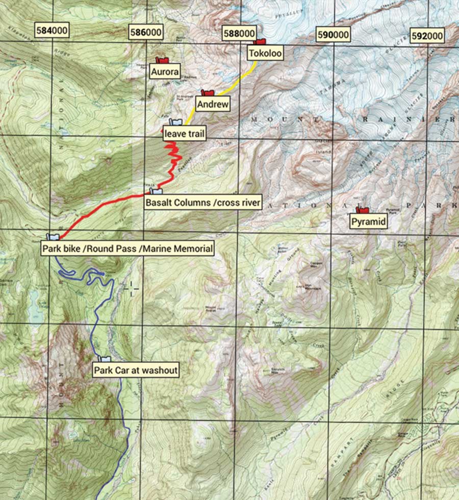
Enter the park at the Nisqually entrance and drive a short distance to the West Side Road. Turn left onto the West Side Road and continue until the barricade. Due to danger from rock fall, vehicles must park south of the barricade at Dry Creek. Hikers and bicyclists should travel through the area with caution and avoid lingering in the hazard zone.
Route Description to the monument: Bike or hike approximately 3.6 miles to Round Pass. Park the bike at the large turnout at the Pass. The Marine Monument is located approximately 100 yards beyond the pass. The monument memorializes 32 Marines who died in a plane crash on December 10, 1946. The plane was en route from San Diego to Seattle and, owing to bad weather, flew off route and crashed into the South Tahoma Glacier.
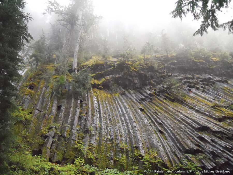
Route description to the basalt columns: To reach the basalt columns, take the trail at Round Pass on the east side of the road. This trail joins the South Puyallup Trail in approximately half a mile. In another mile you will come to the basalt columns on the right, just before the South Puyallup River Campground.
Andrew and Tokaloo Rock
Route Description to Andrew and Tokaloo Rock (these are scrambles and require route finding): From the South Puyallup River Campground, cross the river heading north and stay on the Wonderland Trail. At around 6000’ (before you begin to descend on the trail) leave the trail heading east and then northeast. Stay to the south of Andrew Peak and continue northeasterly toward Tokaloo Spire staying to the south of the ridge. Go beyond Tokaloo Spire, heading north and on the west of Tokaloo Peak. Go beyond the peak and double back, approaching the peak from the north. Andrew can be scrambled either on the way to or from Tokaloo Rock. From the south side of Andrew, head up an easy gully immediately east of the peak. Bear northwesterly toward the col and then counterclockwise until reaching the
flat summit.
Notes: Andrew and Tokaloo Rock are scrambles and should only be done by Mountaineers with these skills. One can have a great day even without undertaking the scrambles. A wonderful outing would be to hike the Wonderland Trail heading north and continue as far as time and energy permit. This part of the park is particularly scenic.
Columns, Andrew and Tokaloo MAP
Skill level: Easy hike (unless scrambling to Andrew or Tokaloo Rock)
Beauty: 6 (on a scale of 10) to Round Pass and basalt columns, 8 to Andrew, 10 to Tolaloo Rock
Distance (RT): (includes 7.2 miles on bike)
10 miles for basalt columns, 17 miles for Andrew , 18.4 miles for Tokaloo Rock
Elevation gain: 1500’ to basalt columns, 4300’ to Andrew, 5200’ to Tolaloo Rock
Total time: 5 hours for basalt columns, 11 for Andrew, 12.5 for Tokaloo Rock
Best season: Summer into fall
Maps: USGS Mt. Rainier West, Mt. Wow, Green Trails Mt. Rainier West
Equipment: Hiking gear (unless scrambling to Andrew or Tokaloo Rock)
Want to learn more?
Guide to 100 Peaks at Mount Rainier National Park is available on iTunes and as an electronic book (for tablets and phones). It is also available as an iBook through the Apple bookstore. The new, second edition was published in the summer of 2014. All royalties are donated to The Mountaineers.