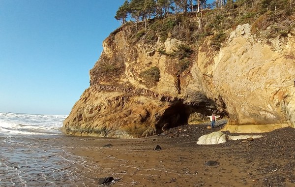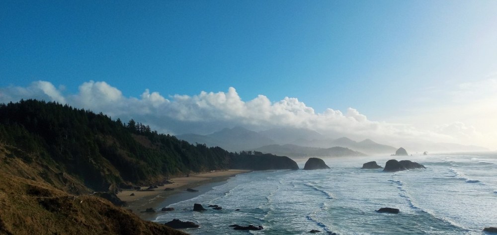
What I find fascinating about the Oregon Coast is that geological events helped shape what we see today. The Colombia River Basalt Group is a series of flood basalts similar to what is found in Hawaii, where large amounts of basalt erupt and cover an extensive area.
Originating near the border of Washington State, Idaho and Oregon, they are one of the best-preserved continental flood basalt events found in the United States. The eruption series began over 17 million years ago, during the Middle Miocene (17 million to 6 million years ago). Over 300 hundred flows happened in the first half-million years. The eruptions continued for 11 million more years, covering an approximate 81,000 cubic square miles. In some areas it reaches over 13,000 feet thick. That is a lot of basalt!
The flows are attributed to hotspot activity upwelling through the Earth’s crust. Eruptions arise as fissures open up in the crust allowing fluid volcanic rock, basalt, to erupt onto the surface. The hotspot that is attributed to the Columbia River Basalt Group is thought to lie under Yellowstone today, making it one of the most dangerous volcanoes in the world. As the North American Plate moved westward, the eruptions progressed. Flood basalt events are often triggered by hotspots. During the effusive eruptive phases, there was little time between events. These flood basalts basically inundated the landscape between Idaho, Washington and parts of Oregon, through low lying valleys, across the lower Cascade Mountains, and down through the Colombia River Gorge, and out to the Pacific Ocean, the terminus of which is at Yaquina Head, Oregon.
Once the basaltic lava flowed into and sank down into the softer sediment known as the Astoria Formation, it created secondary submarine volcanoes, such as Haystack Rock. Others cooled and hardened into thick basalt formations. These basalt formations have become visible, not just from erosion, but also due to the activity of the Cascadia Subduction Zone.
The Cascadia Subduction Zone is a 600 mile-long earthquake fault line stretching just offshore from California to British Columbia. The Coast Range and the Cascades are two parallel mountain ranges that form the Cascadia Subduction Zone in the Pacific Northwest. Oregon lies at the convergent continental boundary, where the Juan de Fuca Plate is subducting under the North American Plate.
It has taken millions of years of tectonic uplift, erosion, and changes in sea level to expose the dramatic headlands, sea stacks, sills, and rocky coastline we see today. These striking basalt headlands and formations are what make Oregon’s Pacific Coastline iconic and memorable.
Ecola State Park
The day we visited, the park was shadowed in clouds, gray and rainy. Thankfully, the rain stopped just enough for the glorious sunshine to come out and play.
Ecola State Park is short drive north from Cannon Beach. Named for the Clatsop word “ekoli,” for whale, Ecola State Park offers several miles of hiking trails, cliff side viewpoints, secluded coves, miles of sandy beaches and tide pools to explore, and grassy wide open picnic areas to enjoy bird and whale watching.
The area used to be a private summer home for the wealthy in the 1930’s. The families, most of them philanthropic-minded, came together and created the Ecola Point and Indian Beach Corporation, in order to donate 451 acres of their lands to the brand new park system, established in 1929.
Ecola Point was developed between 1934 and 1941. The Civilian Conservation Corps (CCC), under the Roosevelt administration and the National Park Service were brought in to help. A work camp was established at the park in 1934, creating much-needed jobs to combat the economic turmoil of the Great Depression. The CCC developed trails, improved roadways, built water systems, constructed picnic areas, and the built the stonework still visible today. The park was completed in 1936.
By 1948, 300 more acres were added to the park. Today over 1,000 acres are protected from the north end of Cannon Beach to Seaside. Thankfully, many homeowners either sold or donated their parcels to Oregon State Parks. The tradition continued in 1994, with a family donating land around the northeast boundary, creating an even larger forest buffer for the park.
A landslide in the early 1980’s dropped a portion of the park right into the ocean, taking with it many of the CCC’s buildings. A landslide in March of 2020 closed a significant portion of the park to driving, camping and, hiking. Many of the areas within the park are still off limits and closed today.
Ecola encompasses Tillamook Head between Seaside and Cannon Beach, stretching along 9 miles of coastline, and is noted for its Sitka spruce forest. Eight miles of the parks trails are a part of the Oregon Coast Trail (OCT), as well as designated a part of the Lewis and Clark Historic Trail.
Capitan William Clark and 12 members of the Corps of Discovery traveled through the area in 1806 in search of a beached whale near present day Cannon Beach. Clark described Tillamook Head as “the grandest and most pleasing prospects which my eyes ever surveyed.”
The area was so grand that it was considered for a lighthouse to aid in navigation for ship approaches to the Columbia River Bar. Thankfully, the area was not quite suitable as the summit is often shrouded in fog, so southerly views were not visible from the Columbia.
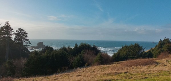
Tillamook Rock Lighthouse can be seen in the distance | Regina Robinson
The 1985 film, The “Goonies” was filmed on location in Astoria and Cannon Beach. The scene where the Goonies started their treasure hunt, and the Fratelli family’s hideout, the Lighthouse Lounge, were temporarily constructed at Ecola Point.
Several other films have used Ecola State Park as a filming location. You might recognize the carnival scene in “Kindergarten Cop”, filmed next to the parking lot, the finale of “Point Break,” and the beach stroll in “Twilight.”
Even though the sun came out to play, I did not get a chance to explore further than just beyond the parking lot. My folks were with me that day, and the trails were too muddy and slick for them to hike. With safety in mind, we paused to have a snack with the hopes that we would be able to spy migrating whales. This area begs further exploration, and I will be back soon.
Things to note:
- The trail is closed between Tillamook Head north trailhead in Seaside, and Hiker’s Camp trailhead at Indian Beach.
- Oregon Day Use Parking Permits are required
- Drones are not allowed in the park to protect shorebirds
- Landslides have been known to occur quite frequently in the park, so please heed all safety signage
- Headlands and tides can be dangerous, so please check current updates before heading down to the beach
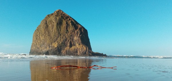
Haystack Rock at Cannon Beach | Regina Robinson
Haystack Rock at Cannon Beach
Haystack Rock at Cannon Beach was named a National Wild Life Refuge in 1967. It is an iconic must-see along Oregon’s coast; yet, most folks do not know the story of how Haystack Rock came to be protected. People used to scale the rock, even after it became a wildlife refuge. Climbers often disregarded signs posted prohibiting unauthorized climbing on Haystack Rock. They frequently disturbed the thousands of nesting seabirds.
In order to protect the wildlife in the newly established refuge, city officials decided to take drastic steps to discourage climbers. During the early part of the 20th century there used to be a trail leading to the top of Haystack Rock. It ranged from 2 feet wide to a very narrow couple of inches. In 1914, it was reported that a man climbing on the rock fell to his death, and his body was never recovered.
In 1935, another man went so far as to cut handholds into the rock with a hammer and chisel. The 1950’s saw an uptick of daredevil climbers, who often needed to be rescued by helicopter. Over the next several decades climbing on the rock increased.
1968 has been called the “Summer of Dead Baby Birds”. One person got stuck when climbed to the top of Haystack Rock right in the middle of the nesting season, and needed to be rescued. Unfortunately, the rescue helicopter created hurricane force winds, which instantly sent thousands of nesting baby sea birds slamming into the ocean. Reports from locals stated that the “dead baby birds washed up on shore for days” afterwards. Horrifying!
October 8th, 1969 was a day that left Haystack Rock forever changed. Dynamite crews began rock blasting early in the morning, removing a ledge, which was supposed to stop climbers from gaining access, and to discourage them from further climbing endeavors. Even after taking these measures, people still tried climbed the rock, ignoring the protections put in place to protect the nesting seabirds. Then, in 1973, someone tried to land a helicopter on top of the rock. The pilot failed, crashing their helicopter onto the beach. All I can do is shake my head in disbelief. Nowadays, climbing on Haystack Rock will land a person in jail.
Haystack Rock, as part of the Oregon Islands National Wildlife Refuge, is a state protected marine environment. The area surrounding the basalt monolith was established as a Marine Garden in 1991. Visitors are encouraged to look, but not touch the animals found in the tidal zone. Before we walk on the beach we usually head out to Haystack rock to explore the tidal pools. Unfortunately the incoming tide prevented us from getting any closer, so we walked the beach instead. At low tide though, this area is an awesome place to explore. Many intertidal animals call this area home. On our last visit we counted over 30 different animals living in and around the tide pools.
Above the barnacle high tide line, Haystack Rock is prime habitat for Tufted Puffins, cormorants, and other sea birds. Over 2,000 nesting seabirds come home to roost on Haystack Rock each year. Because of its protected status, visitors are prohibited from disturbing the marine life and nesting birds. Nest abandonment, dead chicks, and failure to reproduce are the result of human interference with nesting seabirds.
Visitors are also discouraged from climbing and walking on the rocks surrounding Haystack Rock. They are encouraged to leave behind what they find such as rocks, shells, and wood within 300 yards (the length of three football fields) surrounding Haystack Rock. Flying drones within 2000 feet of Haystack Rock are also not allowed. Research indicates that heavy usage of an area impacts habitat, sometimes beyond repair. Violations of wildlife laws come with stiff penalties and fines.
The best time to enjoy the tidal pools is just before and during low tide. Tidal zones are notoriously dangerous, so be sure to practice beach safety by checking tides, and never turn your back to the ocean.
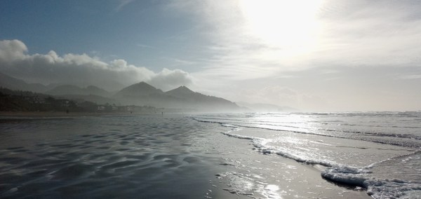
View south of Haystack Rock looking towards Hug Point | Photo Regina Robinson
Hay Stack Rock and the Needles | Photo by Regina Robinson
The town of Cannon Beach offers just as much fun for exploring. The city is known for its prominent sculptures and art displays. Public art is a form of community expression, and to me, a city that embraces public art, builds cultural awareness, and improves quality of life for both residents and visitors. These are a few pieces found in Cannon Beach:
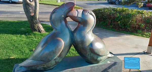
Tufted Puffins by Georgia Gerber, of Clinton Washington | Regina Robinson
During winter months, Tufted Puffins spend their time on the open ocean, but come springtime, they return to their nesting sites to raise their young. Although Haystack Rock boasts a large nesting site, the Tufted Puffin population has been in steady decline since 2002. U.S. Fish and Wildlife noted that the steady decline in Oregon’s Tufted Puffins populations are attributed to “at-sea mortality due to direct human impacts, long-term changes in the marine food web (lack of forage fish) and disturbances at nesting sites.” While the Puffins are protected in Oregon, Washington, California, they are not listed as endangered.
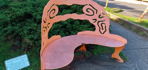
Contact [No.1 Bench] by Alisa Looney, Portland Oregon | Regina Robinson
This artful bench speaks volumes amid a pandemic. Although “Contact,” was created way before the pandemic, contact during the pandemic is the last thing people want, but are so desperately in need of. Ms Looney’s bench brought forth all the emotions of missing friends and family. “Contact” resonated with me. The lack of physical touch is proven to cause mental and physical health problems. I not only miss the physical contact of hugs, pats on the back, massages, handshakes and high fives, but those social dinner parties, outings, and get-togethers, that are a major part of one’s usual life.
People chronically lacking social contact experience elevated levels of depression and stress. I can definitely feel this! Finding a way to keep in contact with those you love was the key message I received from Alisa Looney’s wonderful art piece. I needed this reminder! I decided at that moment to consciously step up the phone calls, emails, and texts, to loved ones. I even chose to start hand-writing letters. There is something special about a hand-written note to say, “Hello, I’ve missed you.”
Now more than ever, social contact and connectedness is critical to our mental health and wellbeing. Reach out to a loved one today. Reaching out generates positive social, emotional, and physical well being, not just for you, but others as well.
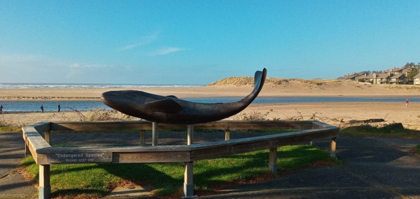
Whale sculpture and Ecola Creek | Regina Robinson
This bronze sculpture commemorates the visit of Lewis and Clark’s Corps of Discovery in 1806. Sometime prior to December of 1805, the Lewis and Clark expedition stationed at the mouth of the Columbia had heard of whale that had washed ashore not too far south across the river.
Captain Clark headed south in a canoe to trade with the local Tillamook Tribe along a then unnamed creek, which he named ” Ecola”, the Chinook and Clatsop term for whale.
Clark’s main goal for the visit was to trade with the local tribes for some of their valuable supply of blubber, to enhance their own meager rations of elk, dog, and fish, and whale oil to light their lamps. Upon arriving, Captain Clark measured the whale carcass. He stated in his journals that it was 105 feet in length, though badly deteriorated and skeletal. The whale carcass was thought to be that of a blue whale.
Clark’s trading went well, and he and most of his expedition, returned to Fort Clatsop on January 10, 1806, bringing with them 300 pounds of whale blubber, several gallons of whale oil and baleen, the filter feeding system found in large whales to sieve prey.
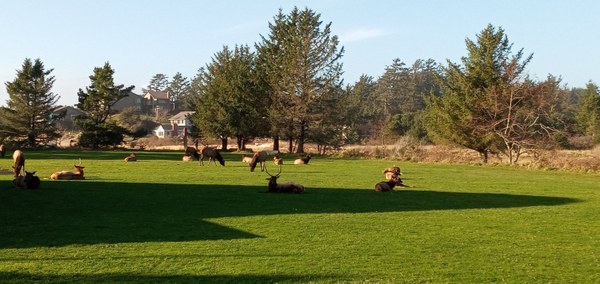
Roosevelt Elk herd in Cannon Beach | Regina Robinson
Winter months find the local herd of Roosevelt Elk often lounging in town, occasionally swimming out near Haystack Rock, and taking long meandering walks on the beach. One of their favorite spots to graze is along the banks of Ecola Creek. While winter provides excellent viewing opportunity of the local herd, it is a stressful time for wildlife. Their survival is dependent upon conservation of energy, and although they may not show indications or visible signs of stress, human interactions can significantly impact their health and survival rates. US Fish and Wildlife suggests decreasing the stress of the herd by remaining 100 yards from wintering elk, never surrounding them or cutting off their direction of travel, and never getting close enough for that “selfie with an elk.”
Trees at Hug Point beach access | Regina Robinson
Hug Point State Recreation Site
Hug Point State Park is just five miles south of Cannon Beach, and has 42.5 acres of beach access to explore. The park is day use access only, and picnic tables and restrooms are available. Signs warn to be mindful that cliff walking is dangerous. Cliffs are unstable and can give way at any time. Check tides for safe travel around headlands and visiting the sea caves.
Adair Point | Regina Robinson
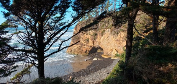
We visited Hug Point on a sunny, cold December morning. The sky was bright blue, a welcome relief from the rain. Incoming waves lapped gently onto the rocky beach, creating a cacophony of sounds as they retreated swiftly back across the rocks. Seagulls peacefully rode the tide, bobbing up and down searching for food. Beachgoers often stooped down to examine colored rocks found on the along the shore. Several people sat still in silent reverence, as if statues, worshiping the sun. Children’s laughter could be heard as they raced in and out of a small cave, carved into the hillside, darting the incoming rising tide.
The walk down to the beach from the large parking area is quick, along a densely hedged forest lined trail of low shrub salal, oregon grape, sword ferns, kinnikinnik, and bunch grass. The windswept bluffs play peek-a-boo among the stately, Sitka spruce, western red cedar and western hemlock. These bluffs are characteristic of much of the Oregon coastline.
Hug Beach is a wide sandy beach[i], but the day we went, all we saw of it was a short rocky expanse. Meriwether Point to the left and Adair Point to the right framed the black rocky beach. Hug Point is actually located at a short distance just behind Adair Point. The rapidly rising tide made a trip around the headlands dangerous. Checking the tides is a good idea before beach exploration; people have been killed, severely injured, and left stranded due to rising tides. Beaches and sand spits are directly influenced by tidal action and un-vegetated beaches are unstable. Traveling around headlands during tide changes, can be dangerous.
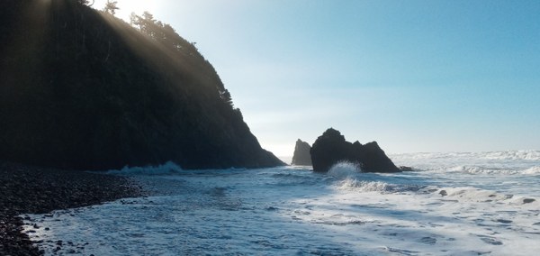
Heading left from the beach access point, we chose to make the short hike south to Point Meriwether[ii] first. Here, two slanted sea mounts can be seen, which at low tide can be bypassed, allowing access to the beach at Arch Cape, a mile beyond.
Point Meriwether | Regina Robinson
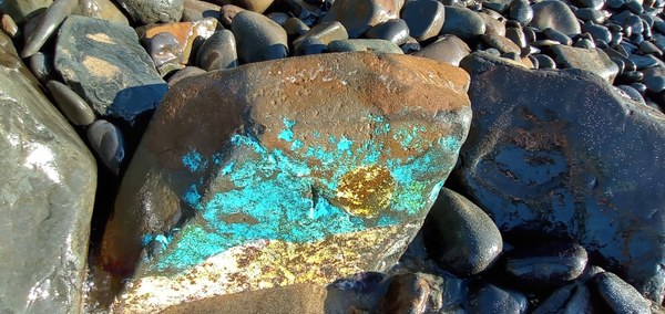
As we made our way back from exploring near Point Meriwether, we stopped to examine the many different kinds of rocks we found on the beach. Most were black, basalt, smooth and rounded, yet there were quite a few, just different enough to require a second look.
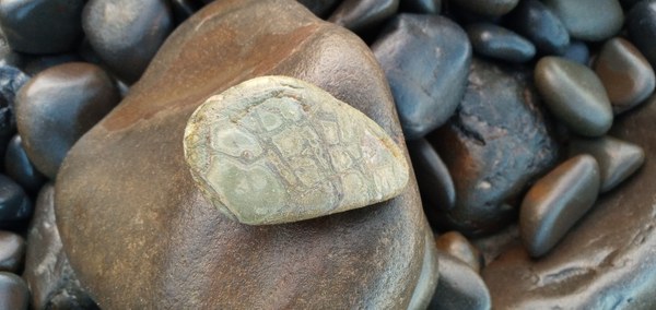
Some rocks looked painted. | Regina Robinson
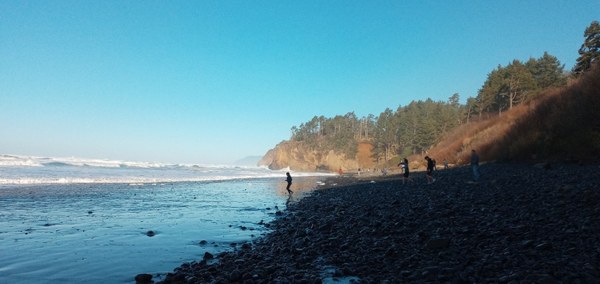
Looking back towards Adair Point | Regina Robinson
Just behind Adair Point lies Hug Point and Fall Creek. Although we couldn’t travel around the headlands during this trip, Hug Point is worth visiting. Hug Point, like other prominent headlands along the Oregon Coastline, divides long stretches of beaches making travel slow and arduous. Hug Point is famous for the old stage coach route that can be seen at low tide, cut into the bluff. The road was carved into the cliff to make travel possible along the beach during low tide to help move freight and mail via stagecoach and wagon. This route is originally a part of the native local tribe’s earliest footpaths connecting local coastal communities. On the cliff side you can still see foot and hand holds carved into the hillside to help early travelers navigate the point during tide changes.
Prior to the building of Highway 101, travelers, as early as 1886, often drove their wagons and stagecoaches along coastal beaches at low tide. The process was slow and inefficient. The primitive roads linked isolated coastal communities with each other and important shipping ports, influencing the development of the Oregon Coast. Troubles with early travel along the coast included roads that were rough; steeply graded, made of crushed rock or shell, and the ones that ran along the sandy beaches dependent upon low tide.
My Pops and Adair Point | Regina Robinson
During low tide, you will see the deep ruts cut into the cliff side, evidence of travelers that “hugged” the point. Look closely and you can see the grooves in the rocks left behind by their wheels.
By 1910, the road was new and improved, carved out of solid rock. It opened the doors to travel by motorized vehicle, but even with improvements, the Hug Point road remained dangerous and rough. Travel was depended upon the tides, and at high tide, it was inaccessible.
The new improvements included using a rock crusher to “lay crushed rocks coated with cement binder,” a system called “macadaminzation,” to allow for smoother travel, reducing the “delivery time for mail.” Check out US 101 Coast Highway Historic Context, pages 35-38 to see early photos of the Hug Point road.
The tide pools, waterfall, and the sea caves (just north of the waterfall), make Hug Point a great place for a fun adventure. Pack a picnic, your favorite beach towel, a camera, and bring your sense of adventure. This beach, even at high tide, is memorable.
Cliffs, and sea caves, even at low tide pose danger to those that explore. Please check tides and be on the lookout for sneaker waves. During high tide, the beach becomes a different place. Remember safety first.
Notes:
- Dress in layers; weather changes rapidly. Although many of our days started cold and sunny, they often ended stormy and wet. I chose to wear waterproof hiking boots, and wool socks to keep my feet warm and dry. Hats, gloves, a buff, and sunglasses were also must-have travel items.
- Bring a camera and binoculars. Although my cell phone took fairly decent photos – my camera took better ones, especially when it came time for extreme close ups.
- Cell phone services can be spotty traveling along the coastline.
- Headlands and beach travel can be dangerous.
- During the winter holiday travel, not all services and stores were available or open. Plan accordingly.
- We brought:
- A cooler to pack lunches, water / drinks and snacks
- Trash bags & gloves (we picked up trash at many of the areas we visited)
- Wet wipes
- Extra masks
- Gas up and keep car in good repair. Some of the areas along the coast are miles from services, and a tow, if needed would be quite expensive.
- Remember to purchase or bring Oregon State Passes
I hope to hear about your adventures to the Oregon Coast, please drop me a line and tell me about your adventures.
[i] Bobby McCracken, Adair Point, Street View – Jun 2019
[ii] Ethan Schaezler, Point Meriwether, Street View- Jun 2015
 Regina Robinson
