The cell phone has become a popular navigation tool for the modern outdoor adventurer. In fact, these days there are so many apps available it can be hard to know where to start. But don't be deterred! Your friends on the Seattle Navigation Committee love this stuff, and we took the time to review several apps that are free or close to it.
Before we get into the review, let's make sure we're all on the same page. We'll be taking a close look at GPS apps. You can think of these apps kind of like Google Maps for the wilderness. They have various features (which we'll dive into) depending on the app, but the defining attribute is that they utilize a satellite signal to allow the user to look up their geolocation.
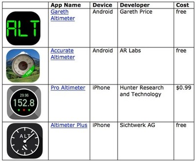
In addition to GPS, there are phone apps that serve as altimeters, measuring the traveler's altitude. Below our review of GPS apps we provided a few altimeter app recommendations (please note that some GPS apps also track altitude).
Also be aware that Mountaineers members get one year free of GAIA Pro, the current gold standard in navigation apps.
Free (Or Nearly) GPS Apps
We graded the apps on a 1-10 scale (10 being the best), and we based our evaluation on the following ten factors. If some of the criteria sounds like Greek, take one our navigation courses! And also know that you don't need to activate all these features to use the app.
- Backcountry oriented (topographic maps rather than street maps)
- Works offline, in airplane mode, with only the GPS activated
- Can display UTM coordinate system and Latitude/Long
- Can operate on multiple North American Datum versions (must have NAD83/WGS84, but gets extra points if it has NAD27)
- Available for Android *and* iOS
- Able to save data and send in GPX format (a file type that allows users to share data like waypoints, routes, and tracks)
- Able to import GPX format
- Accurate (although I believe it's based on underlying GPS hardware)
- Can be shared on a cloud service
- Free
Android GPS App Reviews by Brian Starlin
GPS ESSENTIALS (mictale.com) | Score: 5
Only available on Android. It only uses cached maps, which limits its offline usefulness. Very robust dashboard, highly configurable. Limited selection of map sources
The UI is clunky. It uses a thing called "streams" to store data. The Import/Export functions were hidden in the "streams." The track recording was also buried in the stream screens. The Dashboard is great, but the other functions are clunky.
HANDY GPS (BinaryEarth) | Score: 2
Great for just displaying your coordinates in various formats. It has very limited maps -- a blank screen, and the Google Maps. The map does not work offline and cannot be downloaded.
MYTRAILS (FrogSparks) | Score: 6
Great selection of maps. I think it has only NAD83/WGS84 because I don't see a Datum setting. Tracks and waypoints can be saved as GPX. The free version can only save the current track, plus one. And can only store 100 tiles at a time in the offline storage. UTM displays on the screen. It's on Android.
RAMBLR (Bientus) | Score: 2
This is more of a journaling and trip sharing app than a GPS app. It's very focused on tracking and sharing details of a trip. It has Google Terrain and OpenCycle maps. It can use an offline map. It does not display coordinates, but it can show you your location on the map background. As I said, it's a journaling app.
- Brian Starlin is the Seattle Navigation Chair and a frequent Navigation Northwest contributor. Contact him at brian.starlin@comcast.net.
iOS GPS App Reviews by Emma Agousta
ALL TRAILS | Score: 3
Free. Oriented for hiking on trail (not backcountry). More like the Washington Trails Association app. Works offline and uses WGS 83/84. Available for IOS and Android. Map overlays (such as USGS topo) are in the Pro version ($29.99/year). No UTM or Lat/Long. Other features/Comments: ability to track a route, keep history etc. Many other apps do this for hiking, biking, running and other sports. I do not believe these are the kind of apps our readers are looking for.
ALTIMETER GPS | Score: 4
Free. Not backcountry oriented. Lat and Long: yes. No UTM. Elevation (ft/meters). Accuracy: unknown. Some features only work with internet (i.e. choice of map format). Other features/comments: Weather, barometric pressure, compass heading, step counter, speedometer. Save position. Ads (non intrusive at the bottom, yet one can accidentally click). Find feature to search for location.
DECLINATION | Score: 1
Free. Not backcountry oriented (map: satellite view). Shows Lat/Long and UTM. Works offline: yes. Accuracy: unknown. Other features/Comments: Declination; Ability to search by Lat and Long. Ads.
HANDY GPS | Score: 6
Free. Not backcountry oriented. Works offline: yes. Shows UTM and Lat/Long (plus elevation). Available for both IOS and Android. Able to save data and email : yes. GPX file: no. Accuracy level (+-10m). Other features/comments: Nice display: uncluttered; intuitive, user-friendly; Key features: map and digital Compass. Can save way points and email position from within the app. No ads. My favorite among the free apps, but cannot compete with Gaia.
MAP TOOLS | Score: 3
$0.99. Street oriented. Works offline. Shows Lat/Long and UTM. GPX format: no. Accuracy: unknown. Other features/comments: not intuitive. Confusing zoom in and out feature. Declination provided.
- Emma Agosta is a Seattle Navigation instructor and committee member. A geologist, she is fluent in land forms (and Italian). Contact her at emagosta@gmail.com.
Altimeter App Recommedations
If you're looking to learn more about all your altimeter options (app or otherwise), check out How to: Pick an Altimeter. And below are four altimeter app recommendations from scramble leader Lynn Graf.

This post was originally published in Navigation Northwest, Seattle Navigation's quarterly newsletter/journal. You can find the full publication online.
 Peter Hendrickson