South Point Lookout Trail #123 is located in Gifford Pinchot National Forest. The path used to lead to a fire lookout, which was established in the 1920s and dismantled in 1972.
Gifford Pinchot National Forest is one of the oldest National Forests in the United States and is situated in the south central portion of Washington State. It was originally established in 1893 as the Pacific Forest Reserve. In 1949, following a series of reorganizations, President Truman named the area the Gifford Pinchot National Forest to honor the founder and chief of the Forest Service.
When I first heard about the South Point Lookout Trail, my friend described the “excellent views" which were "worthy of the sweat to get to the top.” I was a little worried as he played it up as being “super steep,” with just over 3,000 feet of elevation gain and seven miles roundtrip. Once we got on the trail, I realized that it was steep, but manageable. In fact, it’s a must-do trail!
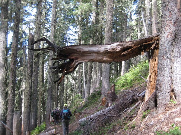
The six of us started off at a brisk pace, heading uphill on an old, unmaintained jeep trail. We crossed over several downed trees as we made our way through the old forest. In 1902, a fire, which came to be known as the Cispus Burn, destroyed thousands of acres in this area. Many of the scars are still visible today. A lightning strike in June of 1918 caused a second large fire, which burned much of the same area. (Fire lookouts weren't established until the 1920s.)
The forest appears to be recovering. The understory (vegetation between the forest canopy and the ground) was filled with ferns and shrubs. The canopy provided much needed shade and a cool reprieve from the sun on our ascent. The trail made me think of the Tubal Cain Trail with its many downed trees.
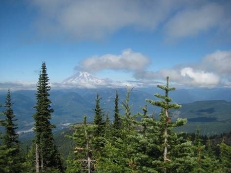
 Panoramic view of Mt. Rainier, Cowlitz River Valley, Goat Rocks, and Mt Adams | Photo by Regina Robinson
At roughly 4600 feet, we crossed over what appeared to be a dry creek bed. Here, we stopped to see if we could find a certain old growth Douglas-fir, a survivor of the 1902 and 1918 fires.
After a couple of miles the jeep trail ends, and the path narrows and becomes rockier. It steadily gains in elevation, switch-backing to the top of the ridge and the remnants of the old, dismantled lookout.
Along the way, we saw plenty of mushrooms, wildflowers, and birds. Every once and a while, through the forest, we could catch glimpses of ridges and mini-peaks located across from us as we ascended.
At roughly 5600 feet we made it to the saddle, with our first real views of Mount Rainier to the north and Goat Rocks to the southeast. Continuing along the saddle for 300+ feet, we emerged to find stunning views of Mount Rainier, the Tatoosh, Cowlitz River Valley, Goat Rocks, Mount Adams, and Mount Hood. Sadly, Mount St. Helens played peek-a-boo among the wispy clouds, never really showing us her true magnificence.
 Hikers on the South Point Trail | Photo by Regina Robinson
We spent just under three hours at the top picnicking, relishing the views, soaking up the sunshine, and relaxing under the deep blue sky – a perfect day to be on the trails. For best views and sunshine lounging, I recommend hiking this trail on a clear, sunny day.
Trip Facts
Location: South Cascades, White Pass/Cowlitz River Valley
Gain: 2900 feet
High Point: 5980 feet
Length: This trail is marked at 7 miles; we clocked it at just about 9 miles roundtrip
Trail: Open to hikers, bicycles, and stock; no motorized vehicles
Parking Pass/Entry Fee: None required
More info: South Point Trail #123
Know Before You Go
Please keep in mind that we didn’t observe any water source on our trip. Make sure to come prepared. Also make sure to carry the 10 Essentials and practice Leave No Trace.
Directions from Olympia
Drive south on I5 for approximately 20 minutes, until you hit HWY 12. Take HWY 12 east for about 1 hr 40 min, roughly 84 miles (3 - 4 miles outside Packwood). Turn right onto Forest Service Road 20, driving up the road for about 5 miles, crossing over a one-lane bridge. Just beyond the bridge is the unmarked trailhead on the left side of the road. Park on right side of road with room for approximately 3 vehicles.
 Regina Robinson