It can feel like access to a reliable vehicle is the eleventh essential for lovers of the outdoors. Summertime, however, brings with it more options for hitting the trails via public transit; an eco-friendly choice that's also kinder to your wallet given current high gas prices (not to mention eliminating the worry of dealing with a trailhead break-in.)
Of course, waiting for public transit or traveling outdoors to a public transit stop is also more pleasant in the summer. I've taken public transit in various countries and around the Puget Sound, and offer a quick sampler of some car-free hikes and tips.
For the hiker seeking challenging climbs
Little Si, Mount Si, and Mount Teneriffe
Public transit is the best way to visit these classic hikes on a summer weekend - zero parking hassles! King County Metro and King County Parks are offering the Trailhead Direct bus service again for the summer hiking season. This service runs on weekends and holidays now through Sunday, September 11, 2022.
- Visit the Trailhead Direct website for more details.
- $2.75 fare one-way; payable in cash or with your ORCA card.
Tiger Mountain
Take the Sound Transit Bus 554, which runs about every 30 minutes, from early morning to about 11pm, 7 days a week, to Issaquah. Hop off just past the public library and police station/courthouse, then you've got several choices. Proceed straight along Sunset Way to access Tiger Mountain via the East Sunset Way trailhead. From this trailhead you can reach the Adventure Trail, the Big Tree Trail, and much more! Alternatively, from the bus stop take the Rainier Trail, a wide signed paved walking path, towards the Issaquah Community Center. At the community center as you face the building to the left the Rainier Trail continues; follow it for approximately 1 mile then cross at the pedestrian crosswalk to the small gravel parking lot for accessing Tiger Mountain by Issaquah High School.
- Fare is $3.25 one-way.
- Visit Sound Transit 554 Bus for schedule and route map.
Squak Mountain via the Squak Mountain Access Trail
Take the Sound Transit Bus 554 for the Squak Mountain Access Trail, which originates at the Issaquah Trail Center parking area at 110 SE Bush St. Issaquah, WA 98027. For approximately 1 mile, you'll follow roads and Issaquah Creek through the Kelkari and Foothills neighborhoods until the trail reaches Sunrise Place. From Sunrise Place the trail begins to travel through more wooded areas. After you cross Sunrise Place, to your left you'll see the wooden sign marking the entrance to Squak Mountain State Park. From here you can access the East Ridge Trail for a challenging climb and to connect to other trails on Squak Mountain.
- Fare is $3.25 one-way.
- Visit Sound Transit 554 Bus for schedule and route map.
- See Green Trails Maps (Map #203S) for Squak and Cougar Mountains.
- WTA.org has a more detailed description of how to access Squak Mountain via the Squak Mountain Access Trail from downtown Issaquah
For the forest rambler
Grand Ridge
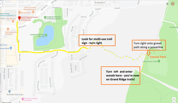
Take the Sound Transit Bus 554 to Issaquah Highlands, but get off at the stop at NE Ellis Drive, which is just before the Issaquah Highlands park and ride (it's okay if you end up at the park and ride, you'll just end up walking a little more). Head towards the Dick's Sporting Goods. Pass the store on NE Ellis Drive, turn left on 10th Avenue NE, then turn right on NE Falls Drive and walk uphill past a large pond on your left. Follow NE Falls Drive uphill and look for a multi-use trail sign on your right. Follow the path through a wooded area and you'll emerge just below Issaquah's Central Park. Above you can see the lights for the athletic fields. Ahead on your right beneath the power lines is a gravel path: turn right onto this path. Walk downhill and you can enter the Grand Ridge trail network - look for the sign on your left. Retrace your steps after wandering on these trails or extend your hike: Grand Ridge's trails connect to the Issaquah-Preston bike path, which connects back to Issaquah Highlands. Alternately, you can follow the Issaquah-Preston bike path down to the East Sunset Way trailhead and then follow East Sunset Way to the 554 bus stop near (water and a bathroom are available at the Issaquah public library close to this bus stop).
- Fare is $3.25 one-way.
- Visit Sound Transit 554 Bus for schedule.

For the beachcomber
Fay Bainbridge Park
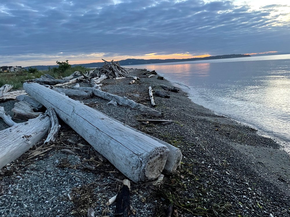
Free on a weekday? Or have a bicycle on a weekend? Take the Seattle/Bainbridge Island ferry then either ride Kitsap Transit bus 96 on a weekday, or your bike on a weekend, to explore this 17-acre marine park with 1,420 feet of saltwater shoreline on the northeast corner of Bainbridge Island. Enjoy sweeping views of Puget Sound and the Cascades - you'll even see Mount Rainier and Mount Baker on a clear day. You can swim at the park's beach, play volleyball, or even have a picnic or barbecue. Showers and firewood are available at the park for a fee. You can also camp overnight! Board the 96 bus at the ferry terminal and exit at NE Torvanger Road and Sunrise Drive NE; walk approximately 1 mile north to Fay Bainbridge Park. Note for your return trip: bus stops along this route are not marked with Kitsap Transit signs, so just wait on the west side of this intersection for southbound travel back to the ferry terminal and flag down the bus.
- $2.00 bus fare one-way; payable in cash or with your ORCA card.
- Seattle-Bainbridge Island ferry schedule. Rides back to Seattle are free; one-way ride to Bainbridge Island from Seattle is $9.25.
- Kitsap Transit Bus 96
Shaw Island, San Juan Islands
OK, so this one probably requires driving to the ferry terminal! However, I couldn't resist including it as you won't need your car once you arrive at Shaw Island. From the ferry terminal it's approximately a 2-mile walk on country roads to Shaw Island County Park, which takes reservations for camping year-round. Ferry reservations highly recommended.
- Anacortes-San Juan Islands ferry schedule
- Mountaineers information on Shaw Island hikes
- Camping reservations for Shaw Island
Tips for a successful experience
- No need for exact change. ORCA cards make paying your fare easy and handle transfers automatically for you throughout the Puget Sound. Download the My Orca app to instantly add funds to your ORCA card and check your balance. Buy an ORCA card at your local supermarket's customer service counter, or online; for the many other locations visit the MyOrca.com website. There is a small fee required to obtain the card initially; lost or stolen cards can be deactivated and the funds loaded transferred to a new card.
- Check the schedule and route map online for each route that you might take ahead of time.
- If possible, see if there's an alternate route in case you need a backup option.
- The OneBusAway app is great for seeing in real-time when your bus or train will arrive.
- The King Country Trip Planner app is also very useful for planning a trip, as well as for checking on route maps and schedules.
- Some routes don't run on weekends.
- Arrive at the bus stop ahead of time. The bus will not wait!
- Always know when the last bus of the day departs.
- Try to avoid multiple transfers; ideally 0-1 transfers tends to work best if you're taking a bus.
- Combine driving and public transit can make using public transit smoother and easier: start at a park & ride or transit center.
- Children/youth, seniors, those with disabilities, and low-income folks qualify for reduced fares. See the MyOrca website for details.
 Gabrielle Orsi