Trip Report
Intermediate Snowshoe - Rampart Vista
Nice logging road style snow-shoe trip to an area rarely visited by Mountaineers.
- Sat, Dec 16, 2017
- Intermediate Snowshoe - Rampart Vista
- Rampart Vista
- Snowshoeing
- Successful
-

- Road suitable for all vehicles
-
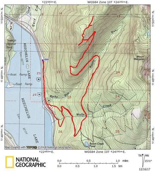
The name “Rampart Vista” is one I made up for the southwest end of Rampart Ridge. Based on satellite / airplane photos it looked like it would be a nice place for a snowshoe trip and I was right. Our trip started at the end of the Gold Creek sno-park road (NF-4382) where it is blocked in the winter just north of Rocky Run Creek. The route we followed was along road NF-4382 up to road NF-136 and followed it north about a mile then followed the road (unnumbered on google maps) that crosses Rocky Run Creek and switch backs north up the mountain. Just before the end of the road is a high bump that we called our summit. We cut a few switch-backs for some variety, (look closely at the topo map track).
There were nice views down to Keechelus Lake at 3 spots along the way, which would have made good turn around points had we wanted an easier trip.

At about 4000’ the road cuts along a steep exposed slope that would not be safe in “considerable” or higher avalanche danger. However, that section can be skipped by going straight up the ridge between 3800’ and 4200’ The ridge has a lot of dense medium sized trees, so this route needs at least 5’ deep snow to go well.
The state grooms road NF-4382, so it is popular with snowmobiles. Consequently it is best to meet at the trailhead at 8 AM so you are ahead of most of them. On our cloudy day, we only say a couple of them. Road NF-136 and the un-numbered road also sometimes get snowmobiles, but less frequently. We saw a few tracks, but they were pretty well buried. I highly recommend doing this trip on Saturdays rather than Sundays so that there will be fewer tracks along the route.
It took us 8 hours to hike the 12 miles up to the end of the road. Our pace was moderate and we took several rest breaks.
 John Gilbert