Trip Report
Alpine Scramble - Petunia Peaks Traverse
A beautiful (and challenging) one day traverse in the Olympics rain shadow, with beautiful alpine lakes, meandering ridge crests, and commanding views in all directions.
- Sat, Sep 7, 2019
- Alpine Scramble - Petunia Peak & North Petunia Peak
- Petunia Peaks
- Scrambling
- Successful
-

- Road suitable for all vehicles
-
Despite a cool, marginally wet forecast (20% precipitation after 11am, 40% later, no mention of lightning), we had no precipitation and comfortable temps, albeit with some dramatic/looming clouds in the distance. No crampons were needed for the small amount of snow on the NW aspect of Petunia (mostly scrambled the rock on the west margin of the snow).
The ascent to Goat Lake (via the unofficial Goat Lake trail) does not mess around, with a steep grade, and a few spots where a misstep could have consequences. After a welcome lunch break at beautiful Goat Lake, we took a westerly, becoming south-westerly, line to reach the Petunia/N. Petunia ridge crest. Taking Fritz Klein’s warnings to heart, we broke up our ascent/descent of the NW gulley into 2 sections that used several protective alcoves on the ascender’s left (north) side of the gulley. Rockfall hazards were avoided using ‘one-person-at-a-time’ between these alcoves (made possible by our small party size of 5).
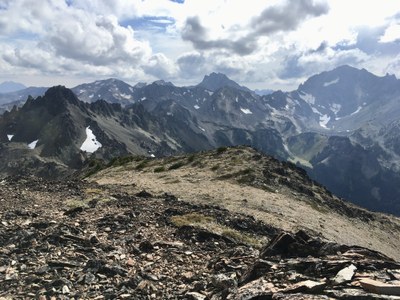
The views were absolutely stunning for the return portion of this trip on the open ridge crest connecting North Petunia, Point 6763, and Point 6626 (W to Gray Wolf Ridge, SW to upper Royal Basin/Deception/Mystery, NE to San Juan Islands, SE to Buckhorn, Marmot Pass, Constance, S to The Brothers).
From ~5600’ on this ridge crest (tending to the east side), we descended through intermittent thick/very thick brush for ~1500’ to more open terrain. By finishing on the east side of this ridge crest we ensured an easier finish/intersection with the Dungeness River trail (versus a more difficult traverse along the south side of Royal Creek). Our approximate times (including breaks): cars to Goat Lake (4 hours), Goat Lake to South Petunia (1 hour), South Petunia to North Petunia (2 hours), North Petunia to Point 6626 (1 hour), Point 6626 to Dungeness River (2.5 hours). The total trip time was just under 11 hours, with an estimated distance/gain of ~14 miles and ~5,500’. Photos can be seen here.
 Dave Morgan