Trip
Alpine Scramble - Petunia Peak & North Petunia Peak
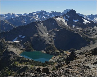
A glorious survey of beautiful Royal Basin plus an interesting loop traverse of Petunia and North Petunia (~14 miles and ~5,500’ gain).
- Sat, Sep 7, 2019
- Seattle Alpine Scrambling
- Scrambling
- Adults
- Technical 3, Strenuous 5
- Challenging
- Mileage: 14.0 mi
- Elevation Gain: 5,500 ft
- High Point Elevation: 6,998 ft
- 1 (5 capacity)
- Cancellation & Refund Policy
Various park and rides to accommodate attendees, then early ferries (or a drive around) for an 8:30AM departure from the Royal Basin trailhead (official name is the Upper Dungeness trailhead #833.2).
This loop traverse will involving hiking along the Dungeness River trail, then continuing to the informal Goat Lake trail that ascends steeply (in a westerly direction) to the basin east of the Petunia - North Petunia ridge. After summiting Petunia, we will bag North Petunia as we follow the expansive ridge crest to the north. Finally we will descend the forested portion of the same ridge crest to reach the Royal Basin trail - Dungeness River trail intersection, and a short hike back to the cars. We are using the clockwise version of this loop to ensure a reliable acquisition of the Goat Lake trail.
Petunia Peaks
-
USGS Mt Deception
Green Trails Tyler Peak No. 136
Green Trails Olympic Mountains East No. 168S
Custom Correct Buckhorn Wilderness - See full route/place details.
Required Equipment
- The Ten Essentials
- Helmet
- Mountaineering Boots
- Ice Axe
- Crampons
