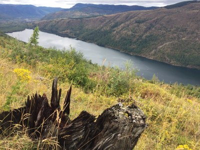
South Coldwater Ridge
Hike to the up Coldwater Ridge where there are views of a volcanic landscape. It's 6.8 miles round trip with 1,525 feet of elevation gain to the Coldwater Peak Trail junction. For more mileage, continue on to the Coldwater Lake Trail, or the Coldwater Peak Saddle.
Temporary Closure
In May 2023, a landslide on SR-504 caused significant damage to the Spirit Lake Outlet Bridge at milepost 49. The upper portion of SR-504 between mileposts 45.2 and 51 will remain closed to the public for the remainder of 2023 and into spring 2024. Visit the WSDOT website for updates.
getting there
Take Exit 40 off of I-5 and drive SR 504, Spirit Lake Memorial Highway, to the South Coldwater Ridge Trailhead.
on the trail
South Coldwater Ridge
6.8 miles round trip, 1,525 feet of elevation gain
Hike the South Coldwater Ridge Trail until you reach the junction for Coldwater Peak (right) and the Lakes Trail (left).
South Coldwater Ridge & Lakes Trail LooP
10-mile loop, 1,650 feet of elevation gain (if a car is left at each trailhead)
The trailheads for the Lakes Trail and South Coldwater Ridge Trail are about 1.5 miles apart, so unless you want to walk the road, it is best to leave a car at each trailhead.
Coldwater Ridge to Coldwater Peak Saddle
11.8 miles round trip, 2,825 feet of elevation gain
Take the right fork and continue on to the Coldwater Peak Saddle.
Coldwater Lake & Boundary Trail Loop
26.5 miles and 9,280 feet of elevation gain (if a car is left at each trailhead)
From the Coldwater Lake Trailhead hike a gentle three miles to the end of the lake and then start gaining elevation. Gain 2,200 feet in 4.8 miles to arrive at the first backcountry lake camp, Snow Lake. Continuing on the lakes trail there are camps at Shovel, Panhandle, and Obscurity Lakes. Backcountry camps only allow for four people per camp. Pass Grizzly Lake and Bear Pass and turn west onto the Boundary Trail. Gain 1,400 feet in three miles to reach the 5,711 ft high point of the trip near the junction with the Whittier Ridge Trail (This is a more primitive scramble trail that passes the summit of Mount Whittier with technical skills needed). Pass Bear Camp and Dome Camp which both have water access via a spring. After 6 miles on the Boundary Trail near Saint Helens Lake head West on the Coldwater Trail which descends 2,500 feet in six miles past Ridge Camp (which has a seasonal water source) to the South Coldwater Trailhead. If you have not left a car here, hike 1.5 miles on the road back to the Coldwater Lake Trailhead.
information for leaders
scheduling
- Please use the Coldwater Lake route/place for scheduling an out-and-back trip on the Lakes Trail.
- The loops can be hiked either direction, however make sure to take a look at the Coldwater Lake route/place for other groups hiking the Lakes Trail. It is okay to hike one of the loops as long as you coordinate with other leaders hiking the Lakes Trail, making sure to start at different trailheads so you may only momentarily pass each other on trail.
- Suitable Activities: Backpacking, Day Hiking
- Seasons: May, June, July, August, September, October, November
- Weather: View weather forecast
- Difficulty: Strenuous
- Length: 6.8 mi
- Elevation Gain: 1,525 ft
- 3,950 ft
- Land Manager: Mount Saint Helens National Volcanic Monument
- Parking Permit Required: Northwest Forest Pass
- Recommended Party Size: 12
- Maximum Party Size: 12
- Maximum Route/Place Capacity: 12
- Green Trails Spirit Lake No. 332
- Green Trails Mount St Helens NVM No. 332S
- Trails Illustrated Mt Saint. Helens/Mount Adams
This is a list of titles that represent the variations of trips you can take at this route/place. This includes side trips, extensions and peak combinations. Not seeing a title that fits your trip? Log in and send us updates, images, or resources.
- Coldwater Lake Loop
- South Coldwater Ridge & Lakes Trail Loop
- Lakes Trail & South Coldwater Ridge Loop
- Coldwater Ridge to Coldwater Peak Saddle
- Coldwater Lake & Boundary Trail Loop
There are no resources for this route/place. Log in and send us updates, images, or resources.
