Trip
Day Hike - Dosewallips River Road Trail
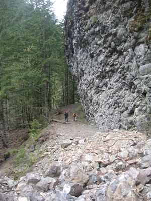
Springtime hike up the Dosewallips river valley. A roaring river, towering basalt cliffs and an old road slowly turning into a terrific trail.
- Sat, May 6, 2023
- Seattle Hiking Committee
- Day Hiking
- Adults
- Moderate
- Moderate
- Mileage: 13.0 mi
- Elevation Gain: 1,200 ft
- Pace: 1.75-2.0 mph
- 6 (9 capacity)
- Cancellation & Refund Policy
0830 at the end of the drivable Dosewallips river road.
The Dosewallips river road is slowly turning into a terrific trail. It passes through several different types of forest along, above and near the river, passing a huge waterfall and towering basalt cliffs just before the campground, which makes a great lunch spot. Possible extra hiking along the river to Dose Forks bridge. Not a lot of elevation gain on this hike but a decent number of miles.
My goals for this trip are:
1. Be safe.
2. Make it up river at least as far as the campground.
3. Have fun.
My expectations for trip participants are:
1. Follow Leave No Trace principles.
2. Have the physical conditioning needed to complete the trip.
3. Be respectful of others.
Dosewallips River/Abandoned National Park Road
-
Green Trails Olympic Mountains East No. 168S
Green Trails Tyler Peak No. 136
Green Trails The Brothers No. 168
Green Trails Mt Steel No. 167
Custom Correct Gray Wolf - Dosewallips
Custom Correct Buckhorn Wilderness - See full route/place details.
Required Equipment
- Navigation
- Headlamp
- Sun protection
- First aid
- Knife
- Fire
- Shelter
- Extra food
- Extra water
- Extra clothes
