Trip
Backpack - Big Sheep Basin, Bonny Lakes, Dollar Pass, Aneroid Lake & Imnaha Divide
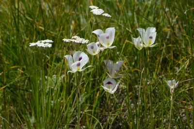
Explore Bonny Lakes-Imnaha Divide loop on a naturalist/photo-oriented backpack up to 27 miles to see the best wildflowers in the Eagle Cap Wilderness, dramatic geology, wildlife, high passes and spectacular views of high peaks from the trail. Possible side trips to Aneroid Lake to camp, North Fork side trails, or Polaris Pass.
- Tue, Jul 27, 2021 — Fri, Jul 30, 2021
- Seattle Backpacking Committee
- Photography, Backpacking, Exploring Nature
- Adults
- Moderate
- Moderate
- Mileage: 27.0 mi
- Elevation Gain: 5,620 ft
- High Point Elevation: 8,890 ft
- 5 (4 capacity)
- Cancellation & Refund Policy
8AM at Tenderfoot Wagon Road trailhead..
UPDATED 7/11/21: Trip rescheduled to 7/27-30 cooler temps from 7/21-24 very hot temps
Covid-19 -- This trip is open only to folks that are fully vaccinated, in accordance with Mountaineers updated policy and leader's preference. Leader will request a copy of vaccination card for proof.
Members only. Minimum 3 persons. Leader permission required with permission link form.
Request permission using leader permission link (and forward copy of completed form in an email, as I am not receiving some permission forms) including responses to following minimum experience/qualifications: Mountaineers multi-night moderate (or higher difficulty) backpacks completed during current and past 2 years, at least one higher elevation (mostly over 7,500') Mountaineers backpack completed during past 5 years, current hiking/conditioning activities, and why this backpack is of interest (backpacking only, wildflowers. photography, etc.) Leader will not review incomplete requests.
** Be sure you read all leader notes and route/place info, prior to submitting leader permission request.
Explore Bonny Lakes-Imnaha Divide loop on an exceptional, less-traveled 4-day naturalist/photo-oriented backpack up to 24 miles to see the best wildflowers in the Eagle Cap Wilderness, dramatic geology, wildlife, butterflies (an Oregon hot spot), savor high passes and spectacular views of high peaks from the trail and camps. Possible side trips to Aneroid Lake to camp, North Fork side trails, and Polaris Pass (trail 1831)
Route (counterclockwise): Tenderfoot Wagon trail to Bonny Lakes, Dollar Lake (camp 1), Tenderfoot Pass, North Fork Imnaha trail, Tenderfoot Wagon trail to trailhead. Allow for possible side trips to Aneroid Lake (camp 2, North Fork Imnaha side trail (#1814, possible camp 3), and Polaris Pass (day 3)
Leisurely to moderate pace to enjoy nature, wildflowers, photography opportunities, wildlife and scenery. If you are looking for a faster paced backpack, please choose a different backpack.
Expect easy stream crossings (via shallow wades with sandals, rock hops, log) on first day and last day, and one or more crossings on other days.
Car camp (Link Creek) or motel accommodations recommended in Joseph, OR area night for the night prior to the backpack.
Trip report for Tenderfoot Trail high trail into the Wallowas (Bonny Lakes/Dollar Lake/Pete's Point/Imnaha Divide, etc.): https://www.oregonlive.com/terryrichard/2012/08/tenderfoot_trail_offers_a_high.html
See link to wildflower list on route/place details.
Consider extending your backpacking in the Wallowas, and add July 26-28 Frances Lake backpack (S. of Lostine).
Daily itinerary: We'll have many opportunities for short or extended stops along trail and near camps to enjoy and photograph the spectacular abundance of wildflowers, mountain scenery and wildlife. Up to 27 miles, 5,620 ft gain and 3,280 ft loss.
Day 1: Backpack from trailhead via Bonny Lakes and Dollar Pass to Dollar Lake (camp), 5.9 mi & 2,000 ft gain.
Day 2: Explore 1-2 mi around Dollar Lake and low slopes of nearby peaks/ridges, then backpack from Dollar Lake via Dollar Pass to Aneroid Lake (camp), 2.5-4.5 mi & 670 ft loss with up to 500 ft gain/loss for Dollar Lake area exploring.
Day 3: Backpack from Aneroid Lake to Tenderfoot Pass and along Imnaha Divide to North Fork Imnaha (camp, along or just S of divide on N Fork Imnaha trail), 4.3-5.3 mi & & 900 ft gain with 900-1,200 ft loss. Possible side trip to Polaris Pass (8,890 ft) for spectacular mountain views, prolific wildflowers along ridge near Polaris and mountain goats; from the 8,200 ft junction on North Fork Imnaha trail adds 4 mi RT & 620 ft gain/loss
Day 4: Backpack from North Fork Imnaha camp via Imnaha Divide and Big Sheep Creek basin to Tenderfoot trailhead, 6.2 -7.2 mi with up to 600 ft gain & 1,790 ft loss.
.
Big Sheep Basin, Bonny Lakes, Dollar Pass, Aneroid Lake & Imnaha Divide
-
Green Trails Wallowa Mountains No. 475SX
USGS Aneroid Mountain, OR - See full route/place details.
Required Equipment
The Ten Essentials plus overnight gear which may include:
- Tent with footprint/ground tarp
- Stove and fuel
- Sleeping bag
- Sleeping pad
- Water filter
- Bear canister or extra stuff sack and cord designated for hanging food
- Cooking pot/pan with plate and utensils
- Toilet paper and shovel or blue bag to deal with waste
- Wading sandals
- Trekking poles recommended
