Trip Report
Mount Baker/Coleman Glacier
A fun, safe and successful climb of the Coleman-Deming route on a great PNW summer weekend.
- Sat, Jul 21, 2018 — Sun, Jul 22, 2018
- Mount Baker/Coleman Glacier
- Climbing
- Successful
-

- Road suitable for all vehicles
-
Overall, the route was in good shape with exception of the icefall area. The crevasses were relatively small and easy to cross, but there were a few that will likely open up as the warm weather continues. We had clear conditions the majority of the weekend, including the summit.
We drove up on Friday night and bivyed/slept in the car just before the trailhead. There’s no space for camping at the trailhead but we found a small pull-out a few minutes away. It was nice to have a relaxed morning and divy up group gear on Saturday, but it definitely wasn't necessary to drive out early on Friday.
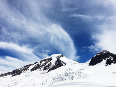
We left Heliotrope Ridge TH around 9:30 am on Saturday. The TH was pretty full, but we found additional parking beyond the bathrooms. The trail was snow free. We encountered a few creek crossings. Going up, the flow wasn’t too strong but it was nice to have poles. You’re in the shade for most of the trail but the final push to Hogsback Camp is exposed, so make sure you have good sun protection. The wildflowers were beautiful and you’ll have great views of Mt. Baker.
We arrived at the end of Hogsback Camp at ~6,000 feet around lunch time. We took our time at lunch and also filled up on water from the multiple streams. This will be your last spot for running water. It’s also a nice rock bed, so we used this time to put on harnesses and rope up but we didn't put on crampons. We had a rope team of three and a team of two. When we arrived, there were a handful of groups already there but there were ample spots open. However, this is where the majority of people camped, so you may encounter crowds leaving in the morning.
Upon leaving Hogsback, we transitioned to snow as we headed toward Black Butte Camp, our destination for the day. The snow isn’t too steep on this stretch and there were multiple boot paths. There were several crevasses on football field. Most of them were small, but be sure to check the snowbridges—here and along the entire route—before crossing. Since it’s been warm this past week, I expect conditions will be changing quickly. We saw a few groups leave Hogsback Camp unroped, as the first section on snow is pretty mellow, but we were glad to be roped up as we made our way to Black Butte camp and encountered crevasses.
We arrived at Black Butte Camp at ~7,000 feet about an hour later and had our pick of locations. We found some nice platforms that had already been dug out, so we camped there. Later on, a few other groups joined us but the site wasn’t too crowded. We set up camp, practiced crevasse rescue, melted lots of snow, made dinner and then got to bed around 7:00 pm. It was quite windy early in the evening but by the time we woke up at 1:30 am, the wind had died down.
We left Black Butte Camp at 2:30 am on Sunday. From camp, we were roped up and wore crampons all the way to the top. There were a handful of groups ahead of us, but I’d say we were in the first wave of climbers heading up that day. There will be a few booth paths from here. Right before the ice fall, we lost the path we were following a little (we were a little too high up) but knew we needed to swing down to enter the icefall.
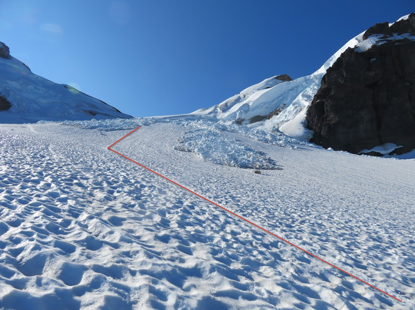
We encountered the icefall at ~8,000 feet. It took about 20 minutes for us to make it through and it lasted up to ~8,500 feet. At this point, there is a pretty clear path through the icefall and we were able to move efficiently. The photo below shows where you’ll enter the icefall. As you’re traveling through, make sure you don’t stop here. Some of the ice chunks were huge!

Following the icefall, you’ll cross several crevasses on the way to ~9,000 feet just before the saddle (east of Colfax Peak). Again, check snowbridge conditions along the way here as some of them may have opened up. The ones that looked most likely to open up weren’t very wide across. A few required a big step over, but no jumping. There were a few times when one of the boothpaths would have taken us over an open crevasse, but there was an alternate path around.
After we were east of Colfax, we encountered the dirt/rock band, but a snow option was also available on the right side. We chose the snow at the start but transitioned back to rock shortly after. If you choose the snow, be aware of its width as it gets narrow quickly. Some of us kept crampons on for ease but others took them off. While we were on rock, we kept the rope shortened.
After the dirt/rock band, we started going up Roman Wall area. It’s the steepest part of the climb but there was a solid, deep boot pack the entire way up. The snow was hard early in the morning. At the very top, there were a few spots where the snow was a little icy and had a loose top layer.
The summit took us ~4 hours to reach. Once we got to the huge flat part on the way toward Grant Peak, we unroped. We hung out for about an hour since the conditions were great—sunny and no wind.
The snow was still hard for our climb down the Roman Wall but it was getting crowded with climbers coming up. We descended to the left of the path we took going up, but there was another track on the right of the main ascent path. We took the dirt/rock band the entire way down, again shortening the rope.
As we got closer to camp, the snow was starting to soften up and get slushy. We arrived at camp, ate lunch and took our time packing up. We roped back up for the final section on snow back to Hogsback Camp but didn’t wear crampons. Toward the end, we were plunge stepping down and the snow was pretty slushy.
We took another break at Hogsback to refill on water and find some hidden trail runners, which always takes longer than you think. On the way down, the flow of the creeks picked up. Again, it was nice to have two poles.
In total, Sunday was a 13 hour day for us, but we took three 1+ hour breaks, so I'd imagine most groups could do it in closer to 10 hours.
More photos from our trip: https://www.flickr.com/photos/joeosowski/sets/72157699055213784/with/43644569891/
 Michelle Flandreau
 Evan Bush